Heritage Register
Gonzales
302 Denison Road
Meteorological Observatory
Built
1913-14
Heritage-Registered/Institutional
For: Dominion Government of Canada
Designer/Architect: Francis Denison/William Henderson for Canada Department of Public Works
Builder: G.C. Hurrell
ARCHITECTURE:
In 1890, Victoria became the administrative centre for B.C. for the Dominion Meteorological Service, and in 1898, of the new Pacific Division, established to deal with the distinct climate and conditions on the west coast. Until 1913, the office was spread out in various government buildings in the city. Constructed for $11,900 on the 63 metre Gonzales Heights, the 12-room facility was said to have the best equipment west of Toronto.
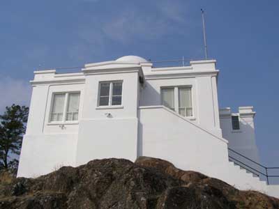
The building has a classical form, emphasized by shallow pilasters on two façades. The cuboid shape is softened by a crenellated and pedimented parapet on the top and an angled step between the floors. Three sides have two-storey towers, all slightly lower than the main structure, and having their own parapets and cornices. The northern entry stands on an open arch, which has now been partially filled in. The upper doorways are accessed via steep, exterior, side-facing stairs, reminiscent of a medieval Welsh castle. The whole structure is reinforced concrete, with extra-thick walls. The east tower has upper windows cut through the cornices, perhaps for better views of the sky. The building has 360º views.
ORIGINAL OCCUPANTS:
Francis Napier Denison (1866-1946), after whom this road is named, gave 40 years of devoted service to the Dominion Meteorological Service. He was born in Toronto, the son of Lt Col Robert Denison, who was influential in the formation of the Upper Canada government, and was deputy adjutant-general of the Canadian Militia. Francis Denison was educated at Upper Canada College and then trained as an electrical engineer. He began his career as an assistant observer at the Toronto Observatory. After further studies in the USA he came to Victoria as assistant to E. Baynes Reed at the weather observatory, then located on Cook St. It was from here that Reed and Denison began providing daily weather forecasts on November 1, 1898.
Denison was interested in much more than weather forecasting and he petitioned the federal government for a new observatory on Gonzales Hill, where there already was a radio-telegraph station. Government architect William Henderson, in consultation with Denison, designed the new station to provide seismological (on the lower floor with equipment attached to the bedrock) and astronomical services for western Canada. Denison was instrumental in including the dome on the structure, for which he acquired a 5-inch equatorial telescope and made it available for supervised public use. The federal government approved a budget of $12,000 and the contract was won by G.C. Hurrell for $11,900. There was no road access to Gonzales Hill at this time and building supplies had to be shipped to Gonzales Bay, then carried up the hill. The station was offically opened on April 23, 1914. Baynes Reed died in 1916 and Francis Denison became director of meteorological services for BC and the Yukon
.
In 1904 Denison had married Ethel Margaret Walbran (1874-1945), who was born in Bootle, Lancashire, England, and came to Victoria c.1895 with her parents. Her father, Capt John Thomas Walbran, was for many years master of the Canadian government ship SS Quadra which patrolled the BC coast. He gave names to many natural features along the coast and wrote the book British Columbia Coast Names, published in 1909. Oak Bay named the park on the height of Gonzales Hill for Walbran.
Francis and Ethel Denison first lived in a house built for them on Superior St. They had no children and soon after the new observatory opened they moved into its living quarters, where they spent almost 20 years. Ethel developed a beautiful flower garden around the building but the garden has now disappeared.
Francis Denison retired, with great public honour, in 1936. Denison was a fellow of the Royal Astronomical Society of Canada and he designed many of the instruments used in his work at the observatory. Among his other designs was a special seismograph for use in mines to detect imminent earthquakes, and a dust remover that was widely used in hospitals. Denison encouraged the interest of the public and schools in the facility, giving tours and lectures.
One of his many responsibilities was to set acurate local time, which was crucial information for mariners. He used a transit telescope to determine when the sun was at its zenith, then transmitted this information by telegraph to drop a time-ball on a mast on top of the Belmont building in downtown Victoria. Mariners within sight of the mast set their chronometers to local time when the ball dropped at precisely 1 pm. The Gonzales station was, for some time, the primary source of accurate time in Canada, west of the Rockies.
Weather forecasting service for the province moved to Vancouver in the early 1940s, with a local office at Victoria airport. By the 1960s the Gonzales station did no more than collect data. However, the building was open to the public and there were regular visits from schools where students could see many instruments, both current and antique, on display.
OTHER OCCUPANTS:
The building was given federal heritage protection in the 1980s, with the highest rating of “classified federal heritage building.” The other two local buildings which received this classification at the same time were the old Customs House at 1002 Wharf St and Hatley Castle. After a land use study of Gonzales in 1987 the federal Public Works department announced a plan to sell off most of the land to the north of the observatory for housing development, and to sell the building itself and the land immediately surrounding it to the City of Victoria for $1. Both the Victoria and Oak Bay councils joined the Gonzales Hill Preservation Society in opposing this plan; a very important aspect of the protest was that the area provides habitat for quail and other birds, as well as some rare plant species. Eventually the entire property was sold to the Capital Regional District for $35,000, and Gonzales Hill became a regional park.
For a short time the observatory was used by the University of Victoria for scientific research; it was later leased to The Land Conservancy.
ADDITIONAL INFORMATION & IMAGES:
• Gonzales History
• Gonzales Heritage Register
• This Old House, Victoria's Heritage Neighbourhoods,
Volume Four: Fairfield, Gonzales & Jubilee