
Heritage Houses

Victoria’s Residential Neighbourhoods


Explore GIS Map
There’s no better way to experience Victoria’s heritage homes than in-person. Learn what each neighborhood has to offer and use the handy GIS Map and information provided to guide your visits.

Burnside
By Dennis Minaker © 2004
This expansive neighbourhood, stretching from the northern edge of downtown through Rock Bay to the city’s north and west limits along Harriet and Tolmie Streets and east to Blanshard Street, was for centuries home to First Nations whose campsites dotted the harbour shore. With European colonization this area soon hosted an extraordinary range of urban development, both industrial and residential. By 1900, waterside factories, mills and shipyards – along with attendant cabins and lodgings nearby for labourers – shared a common shoreline with grand mansions, rose gardens and croquet lawns. Tracks for streetcars and no less than three railroads traversed adjoining working-class neighbourhoods.
The Great Estates - Finalayson, Work, Yates & Woods
Like much of Victoria, residential development began with the sale of raw land from the fur trade reserve in the 1850s, mainly to employees of the Hudson’s Bay Co (HBC). The 103-acre Rock Bay Estate of Sarah and Roderick Finlayson, former chief trader of Fort Victoria, stretched eastward from the water of Rock Bay to the Fernwood area.
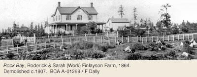
Their rambling 2-storey manor, surrounded by ornamental gardens, orchards and open fields, stood isolated west of Douglas Street, north of Queens Avenue, until demolition c.1907. Bay Street separated Finlayson’s property from Hillside Farm, the huge estate owned by Sarah’s parents, retired HBC chief factor John and Josette Work (see Hillside-Quadra history). Craigie Lea Farm, covering 400 acres along the waterway beyond Cecelia Ravine, belonged to HBC shipwright-turned-publican James and Mary Yates. Harriet Street was named after their second daughter. The Garbally Estate of Anne and Richard Woods, provincial Supreme Court registrar, was established in 1862 on 110 acres bordering Selkirk Water.Richard died at 63 in 1876; Anne managed the estate until her death at 70 in 1883.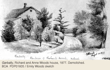
Early Transportation & Bridges
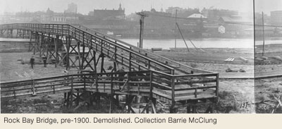
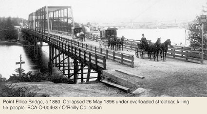
Early access to these properties was by boat along the waterway or a rough ride over crude forest trails. Douglas Street was pushed northward to meet Burnside Road and the old road to Saanich by 1859. Two years later the first bridges were erected over the Arm at Point Ellice and Rock Bay – the latter supported at midstream by a rocky islet for which the small bay was possibly named.
Creeks that flowed into the waterway were also spanned, notably along Douglas and Government Streets near Queens where a meandering stream from Fernwood spilled into Rock Bay as Finlayson Falls. A small water-powered mill was built there in the 1860s. Two bridges along Gorge Road spanned creeks draining the area of Topaz and Speed Streets. The present span overCecelia Creek ravine on Gorge Road was constructed in 1912. Several more bridges crossed upstream at Burnside, Beta and Delta Roads. Tidal water from Rock Bay almost reached John Street, between Bridge and Ludgate, until 1890 when a combination of landfill and bridgework connected Bay Street with the approach to Point Ellice Bridge. A drive-through concrete tunnel still passes under the roadway there.
The area’s longest bridge, the Selkirk train trestle, was constructed over the waterway in 1917 by Canadian Northern Pacific Railway – allowing logs from Cowichan Valley to be delivered directly to neighbouring sawmills. During this period, sportsmen and picnickers bound for Deep Cove on the Saanich Peninsula could ride BC Electric Railway’s Interurban Line from downtown along Douglas Street and Burnside Road. The Victoria & Sidney Railroad (V&S) operated a passenger and freight service from 1895-1919, with a line running north from city hall along present-day Blanshard Avenue. The turntable and engine house were located at Nanaimo and Market Streets. The Albion Freight Yard of the Esquimalt & Nanaimo Railway (E&N) was on the site of Albion Iron Works. Tracks for electric streetcars were laid along Douglas to Hillside (1890), across Point Ellice Bridge to Esquimalt (1891), and along Burnside to Carroll Street (1924). Tram service ended after 1946 when BC Electric Co established their Garbally bus yard on Gorge Road.
Subdivision & Families On Pleasant Street
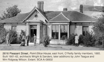
Expansion of the area’s roadways – however rustic – allowed subdivision of the founding estates to begin as early as 1861. The waterside properties near Point Ellice attracted some of the first newcomers, notably Charles Wallace who married Catherine Work from Hillside Farm in 1861 (Point Ellice House, 2616 Pleasant Street), then sold the property to colonial gold commissioner Peter and Caroline O’Reilly in 1868.
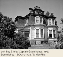
Supreme court judge Montague and Joanna Tyrwhitt-Drake and dry goods merchant, city mayor and BC premier John and Elisabeth Turner also lived on that aptly-named Pleasant Street. Mill owner James and Selina Mann built a comfortable house nearby in the 1880s, as did sealing captain William and Helen Grant.
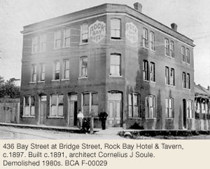
Capt Grant was known to gather up his crew from the Rock Bay Tavern at Bridge and Bay Streets prior to sailing. Their Mansard-style house next to Point Ellice Bridge served as first-aid station and mortuary when the streetcar bridge collapsed in 1896. The western extension of Hillside Avenue from Pleasant Street to Douglas Street attracted the greatest number with 55 houses by 1893. Residents included hackmen, boatbuilders, longshoremen, tannery workers, sawyers and teamsters.
Institutional Life
Local children attended Rock Bay School, built at 2518 Turner Avenue in 1890. It served as a Chinese Public School in the 1920s. Queen’s Academy, a private school for girls specializing in bookkeeping instruction, was opened at 80 Henry Street in 1904 by Stephen Pope (1127 Catherine Street, Victoria West, 648 Niagara Street, James Bay), who moved the school to 2715 Rock Bay Avenue and later to Rockland.
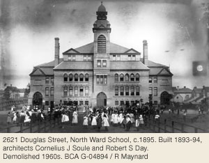
The building is now a 2-storey private residence and office. Children in the Gorge area went to Burnside School (3130 Jutland Road) as of 1913. North Ward Public School was built in 1895 on Douglas Street where the Times Colonist building now stands. A bell tower rising more than four storeys lent the landmark school a superior air not out of place in the fashionable neighbourhood.
The duality of the Hillside/Douglas junction, blending ‘country-living’ within walking distance of town, was highlighted by the construction there of ornamental fountains and troughs in 1885. Tired horses hauling loads from rural Saanich to town welcomed the cooling water while riders preferred to slake their thirsts at the nearby Avenue Retreat Saloon (the fountain now stands in Market Square).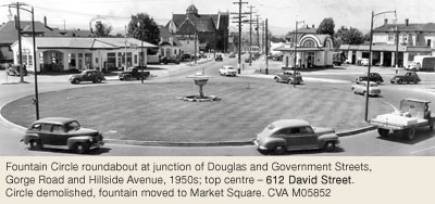
Houses Of The Wealthy, Socially Prominent & Business Leaders 1870s-90s
The desirability of the neighbourhood was anchored in the 1870s when three ‘villas’ were built on Douglas south of Hillside for the families of successful realtor and insurance agent Henry Heisterman (1521 Shasta Place, Rockland), hardware merchant Thomas Tye, and brewer Louis Erb. New residents in the 1890s included postmaster Noah Shakespeare, plumber Andrew Sheret, mill owner Joseph Sayward, Premier Theodore Davie and grocer Dixi Ross – who stabled his race horses on present-day Ross Lane. Westbourne Place was named after the elegant home of federal drydock master Captain John Devereux. A brick house on Douglas Street next to North Ward School housed the families of prominent builders William and Walter Luney. Their construction yard occupied the SE corner of Bay and Blanshard Streets in North Park until the 1970s. The large Arthur Porter house, graced with a 3-storey wooden tower, once stood on the site of today’s Garbally transit yard.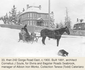
Select houses were also built to the west after Gorge Road opened up in the 1880s economic boom. Waterside lands beyond Cecelia Ravine were especially desirable. Albion Iron Works manager Bagster Roads Seabrook, gasworks secretary Charles Thomson, tannery operator and leather-goods merchant Frederick Norris, retired Okanagan cattle king Thomas Ellis, plus architects John Gerhard Tiarks and William Ridgway Wilson all lived in grand houses within the space ofa few blocks. Turreted Armitage, built at the foot of Washington Avenue in 1894 for Victoria Machinery Depot (VMD) owner Charles Spratt (548 Lotbinière Avenue, Rockland), was especially elaborate, later providing a suitable residence for the large family of Premier Sir Richard McBride.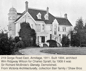
Grandest of all was the brick and stone Jacobean-style manor Ashnola, commissioned by Robert and Joan Dunsmuir (1050 Joan Crescent, Rockland) as a wedding gift for daughter Emily. Completed in 1890, it stood on 11 acres of cultivated grounds now occupied by Gorge Road Hospital.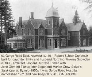
Although houses built in the early 1900s still dominate side streets, Gorge Road was irreversibly changed when it was designated as the Island Highway in 1915. Unwanted large Victorian houses, long past their fashionable youth, were divided into apartments. Demolition followed, making room for rustic auto courts then motels and today’s condominiums.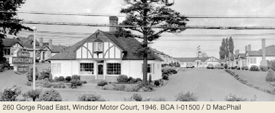
Industry On The Upper Harbour, 1862 To The 1980s
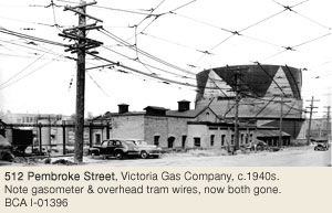
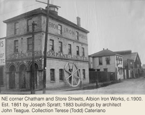
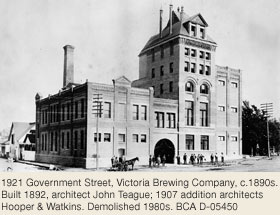
By the time the early estates were being subdivided for residential development, industry was firmly entrenched along the waterfronts of the Upper Harbour. Victoria Gas Co (502 Pembroke Street) and the giant Albion Iron Works (2101 Government Street), manufacturing everything from stoves to boxcars, were both established in the Store/Pembroke Street area in 1862.
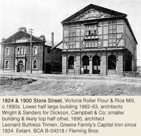
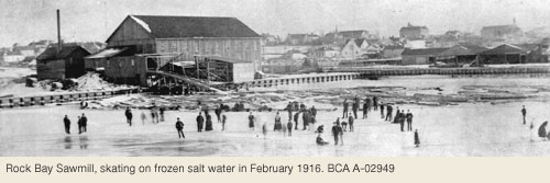
Within two decades, smokestacks, beehive burners and water towers lined the industrial shoreline north of downtown. Freshly-milled lumber for overseas markets was stacked on company wharves, ready to be loaded onto five-masted freighters. Steam-powered tugs pulled barges of coal and pig iron from Britain to feed the growing number of factories. Upper Store Street contained the Rock Bay Sawmill and Victoria Planing Mill that supplied the ornamental throne and other finishing woodwork for the new legislative buildings.
Victoria Roller Flour & Rice Mill (1900 Store Street) was established next door c.1890, followed soon after by BC Electric Railway Co’s powerhouse and car sheds (502-08 Discovery Street). The big parking lot opposite was the terminus and marshalling yard for the E&N Railway, with tracks from the Johnson Street Bridge. Shawnigan Lake Lumber Co was located on Government Street at Discovery, kitty-corner to the 6-storey Victoria Phoenix Brewery that produced beer for almost 100 years. Gone too are the Queen City Sawmill, Capital Planing Mill and Crowe-Gonnason Sash and Door Factory, all founded in the late 1800s along the Government Street waterfront north of Pembroke. Wagon works, blacksmith shops, stables, warehouses, plus wood and coal yards also existed nearby. Surviving structures include the Smith Brothers foundry at 632 Pembroke Street and a former Chinese laundry at 740 Princess Street, both dating back to 1913.
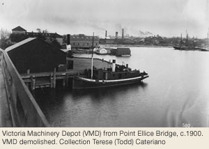
Industrial development spread along the north shore of Rock Bay by the 1870s. Wharves between Bridge Street and Ludgate Avenue – then called Tannery – served two tanneries and a trunk factory. Cow, sheep and goat hides were processed on site for leather-goods shops situated downtown. A floating boathouse for excursionists on the Gorge, shingle mill, match factory, shipyard and fruit cannery also occupied the waterfront at various times. The mighty Victoria Machinery Depot – builder of warships, provincial ferries and even an offshore oil rig at their Dallas Road site – originated near the foot of Turner Street in 1882. Machine shops, boiler sheds, a marine railway and wharves that projected far out into the Upper Harbour were a fixture of this company for more than a century. A fleet of sealing vessels wintered next door at Grant’s wharf, home to the Pacific Whaling Co until the 1940s.
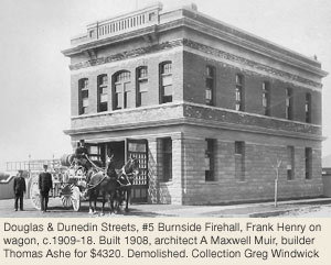
During the early 1900s much of Selkirk Water was covered with log booms to feed three large adjoining mills. Largest was the Cameron Lumber Co (1320 Purcell Place, Rockland), later Revelstoke, established at the foot of Garbally Road in 1908. A changing economy and declining log supply led to its demolition in the 1980s, long after other mills succumbed to hard times and devastating fires. Nor was the Cameron mill immune, being partially burned down twice – despite being near the No. 5 firehall, built at Douglas and Dunedin Streets in 1908. The Selkirk Waterfront Development occupies the mill site now.
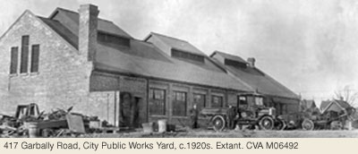
City Works Yard On Garbally, circa 1917
Landfill between Bridge and Garbally Streets facilitated expansion of the city works yard established around 1917. The site still contains brick structures originally built as a wagon shed, blacksmith shop and stables. The enduring Economy Steam Laundry and Commercial Towel Co, on John Street, dates back to 1915. A former box factory (Dalziel Box Co, 70 Gorge Road East and 1128 Topaz Avenue, Hillside-Quadra), fertilizer plant, stone monumental works and soda factory have also contributed to changing the Rock Bay neighbourhood from residential to light industrial. Some small Streets, such as Mill Street and Wood Street, were erased from the map by development.
Businesses & Apartment Blocks
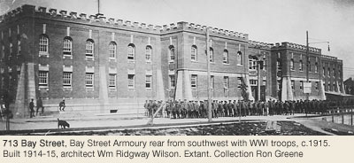
Commerce, quickly spreading from downtown, soon pushed private dwellings out of the Douglas-Blanshard corridor as well. The Field Street Apartments and the Scott Building at Hillside Avenue (originally with housing on the upper two levels) were on site by 1914. The Bay Street Armoury (713 Bay Street), Canadian Bank of Commerce (2420 Douglas Street) and Leland Building – home in the 1950s to the period-evoking Flying Saucer Coffee Shop – followed one year later. 1928 saw completion of the art deco BC Electric Substation, 637 Bay Street at Government Street. All are still extant.
Gas stations attracted by island traffic funnelling into the city became a fixture at the Hillside/Douglas junction by the 1930s – site of a traffic roundabout known as Fountain Circle from 1950–1963. The grassy median was subsequently called Humber Green after a local brick-making family (610 Gorge Road East).
Douglas Street north of the junction was home after WWII to a wooden cycledrome, covered roller skating arena and stables for sightseeing horses, hence the Tally Ho Motor Inn. Construction of Mayfair Shopping Centre in 1963 put an end to a century of brick making on the Douglas Street site. Five companies operated there in the 1890s (Baker Brick Company – 714 Discovery Street, Burnside, and 968 Balmoral Street, North Park), churning out millions of bricks and tiles annually. The biggest change of all was the late 1960s Blanshard redevelopment scheme that led to demolition of North Ward School and more than 100 Edwardian houses for a major road realignment.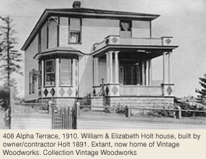
Burnside Heritage Register Properties
22 Burnside properties on the City of Victoria's Heritage Register in 2026
Heritage-designated - Protected by bylaw. Houses eligible for VHF funding.
Heritage-registered - Not protected, may warrant future preservation. Houses ineligible for VHF funding.
Heritage covenant - Protected by legal agreement. Houses eligible for VHF funding.
PHS - British Columbia Provincial Historic Site
NHS - National Historic Site
3140 Balfour Av
Designated 2013
637 Bay St
Registered
713 Bay St
National Historic Site 1991
3040 Carroll St
Designated 2007
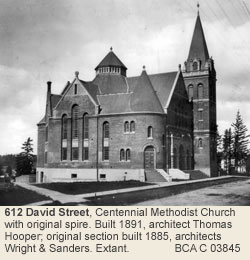
612 David St / 645-51 Gorge Rd E
Designated 1979
502 Discovery St (508 Discovery St)
Designated 2018
714 Discovery St
Designated 1996
2100 Douglas St / 660 Pembroke St
Registered
2420 Douglas St
Registered
2621 Douglas St
Designated 2020
2655-57 Douglas St
Designated 2020
70 Gorge Rd E
Designated 2005
137 Gorge Rd E
Heritage Covenant
602 Gorge Rd E
Designated 1977
645-51 Gorge Rd E
Designated
2101-11 Government St
Designated
3130 Jutland Rd
Registered
502 Pembroke St
Designated 2012
632 Pembroke St
Registered
2616 Pleasant St
Registered / NHS 1966 / BCHS
1910 Store St
Registered
2110 Store St
Designated 2012
Fernwood
By John Adams & William R. Muir © 2004.
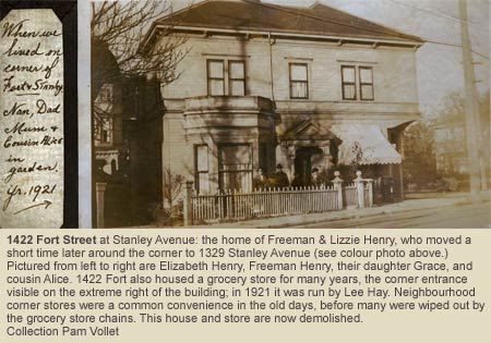
Fernwood has long been noted for its trees on both city boulevards and private property. Neighbourhood corner stores were a common convenience in the old days, before many were wiped out by the grocery store chains.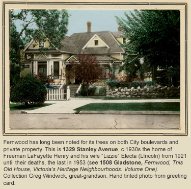
Finlayson & Pearse Estates & Early Houses
The land comprising the Fernwood neighbourhood was Swengwhung (Songhees) First Nation territory until 1850 when James Douglas purchased it for the Hudson’s Bay Company for the sum of £75 sterling. Once surveyed, portions of the tract were purchased for the going rate of £1 per acre by two notable Victoria residents. Section III, the portion west of Chambers Street (extending to Rock Bay) became part of the estate of Roderick Finlayson, HBC chief trader; Section LXXV, the 95-acre portion east of Fernwood Road formed the bulk of the Fernwood Estate, owned by Benjamin W. Pearse, assistant colonial surveyor. In between these two large parcels lay part of Section XVIII, a narrow strip retained by the Hudson’s Bay Company and Section LXX, the ten-acre School Reserve.
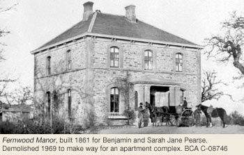
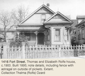
The first houses in Fernwood were country estates built on its southern border in a corridor along Fort Street. In 1860 Pearse built Fernwood, an imposing Italianate stone structure, near the present corner ofFort and Fern Streets and facing what later became Begbie Street, taking advantage of the views looking eastward to Mount Baker. He spent the next four decades improving the house until his death in 1902, and his wife continued living there until her death in 1954. In 1862 Captain Henry Ella built Wentworth Villa, a Gothic Revival house, at 1156 Fort Street. Architect Samuel C. Burris designed 1342 Pandora Avenue at the corner of Fernwood for Joseph H. MacLaughlin in 1883, and at around the same time builder Henry Spofford constructed an unusual home on land leased from Pearse at what is now 2226 Shelbourne Street, prior to that street being Fort Street continued to be a desirable address even after the area began to be built up, and many of Victoria’s stately homes are located there. Trebatha, one of Victoria’s few surviving Second Empire houses, was built in 1887 at 1124 Fort Street, while between 1901 and 1907 three of the city’s more impressive Queen Annes were constructed at 1140 and 1162 Fort Street and 1270 Yates Street, all within two blocks of each other. In 1907 builder David H. Bale built a residence for himself at 1402 Stadacona Avenue called Argos, a massive version of the Edwardian Vernacular Arts & Crafts bungalow that would appear by the thousands in Victoria up to WWI.
Topography, Water & Gravel
Before the land was cleared it was heavily timbered. Harris Pond near the corner of Stanley and Vining Streets was a natural catchment basin for the surrounding ridges. A stream flowed from the pond northward, one block to the east of Fernwood Road. At about Bay Street the stream was diverted by Fountain Ridge and it took a right angle turn to the west, flowing along a zig-zag route within a block either side of Bay Street until it emptied into Rock Bay. The stream provided water for Chinese market gardeners in the early 1900s southeast of the corner of Fernwood Road and Bay Street. Harris Pond and the nameless stream were filled in as residential development took place.
Within Section XVIII of Fernwood is the district known as Spring Ridge, bounded generally by Chambers Street on the west, Bay Street on the north, Fernwood Road on the east and Pandora Avenue on the south. Gravel deposits left after the retreat of the last Ice Age 10,000 years ago underlie this area. Numerous fresh water springs gave it its name. Until the damming of Elk Lake in the early 1870s, these springs were the principal source of drinking water for Victoria. One of the most important springs was on the 1100-block of Princess Avenue. At first, water carriers filled their wooden casks there and sold it door to door throughout the city. Later, wooden stave pipes were used to carry the water to town. At least two breweries (the Lion and the Empire) were established in the vicinity to take advantage of the pure water. Though the springs remain in many basements and backyards, most have been capped, and the water has been diverted into Rock Bay through a drainage system built specifically for the purpose in the 1950s.
The low-lying land at Stanley Av and Vining St forms a natural catchment basin for the surrounding ridges. In the past water collected there, forming a pond that was referred to as either Harris’ Pond or Harris’ Bottom. It was likely named after Thomas Harris who owned the first butcher shop on Vancouver Island and later became Victoria’s first mayor. At its deepest, the pond held about four feet of water. It was drained by a small stream flowing north one block east of Fernwood Rd to Bay St where it supplied water to the Chinese market gardens. From there the stream angled west, meandering north of Bay St and then emptying into Rock Bay.
As Fort Victoria grew, a reliable supply of fresh water became essential. Two sources were located about a mile out – the springs at Spring Ridge and Harris’ Pond. At the time it was thought that Harris’ Pond was fed by the abundant springs in the area. In 1863 entrepreneurs John Coe and Thomas Martin formed the “Spring Ridge Water Company”. They laid pipes made from 12-foot long hollowed-out logs, attaching them end to end and burying them with their bark left on. Pipes were laid from Harris' Pond and Spring Ridge along Fort to the San Francisco Bathhouse on Government St. From there, water was delivered to customers by wagon at a rate of twenty buckets for one dollar. The pipeline also filled 4 large cisterns for fire protection – at no charge.
By 1869 it became evident that Harris’ Pond was not fed by springs and there were frequent complaints in the British Colonist newspaper regarding the quality and quantity of the water. The water supply from Harris’ Pond was described as “a meagre supply of unwholesome liquid” and “a limited quantity of liquid vegetation as thick as pea soup that used to be pumped up from the scummy recesses of Harris’ Pond, the use of which sometimes cause diphtheria and kindred complaints, and rendered cleanliness the exception rather that the rule.” In 1872 the City authorized the construction of water works to bring water from Elk Lake. The pipes from Harris Pond were last used in 1875.
Winters must have been colder in Victoria in the 1800s since the livery stables all had sleighs and the locals enjoyed ice skating on Harris’ Pond. When temperatures allowed, trips to the pond were advertised in the newspaper. Snow was cleared from the ice and the pond was flooded. On January 18, 1868, the British Colonist reported a gay and lively scene at Harris’ Pond, with 150 persons including about 30 ladies skating. A couple of entrepreneurs erected a board shanty for the refreshment of the “inner man and woman” that was liberally patronized. The pond and stream were filled-in by 1890 and little evidence remains today of their importance.
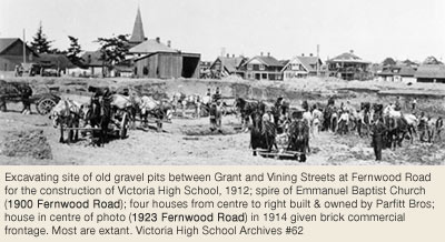
The gravel deposits proved very useful as a source of building materials for the growing city of Victoria. Stevenson Park between Pembroke and Gladstone Streets is lower than the surrounding area because of the large quantities of gravel removed from the site in the early 1900s, some of which was used to fill in the James Bay mudflats where the Fairmont Empress Hotel was built. South of Gladstone Avenue, now the site of Victoria High School, concrete block factories took advantage of the abundant gravel. However, the dust and noise of the unsightly gravel pits were a constant source of annoyance to nearby residents who regularly petitioned City Hall about the issue.
The School Reserve & Other Schools
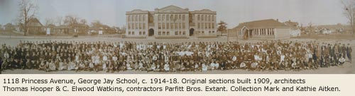
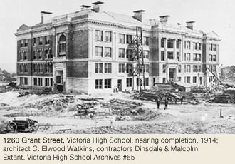
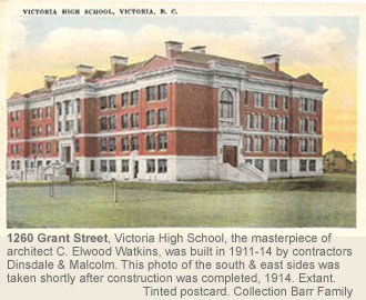
Schools have been at the heart of Fernwood’s social and architectural heritage. The School Reserve, now the site of Central Middle School, was the site of the squared-log Colonial School of 1853, demolished about 1879. It was the first non-sectarian public school in what is now British Columbia. In 1876 the mansard-roofed brick edifice for Boys Public School was built at the head of View Street, and in 1882 Victoria High School, the province’s first high school, was added as an extension to this building. In 1902 Francis Rattenbury designed a new brick high school building that faced Fernwood Road. The 1876 and 1902 buildings were pulled down to make way in 1953 for Central Junior High School, a reinforced concrete design by Birley, Wade & Stockdill, architects. Architect C. Elwood Watkins is responsible for two imposing schools that still stand in Fernwood. In 1909, with his then-partner Thomas Hooper, he designed George Jay Elementary School at 1118 Princess Street and in 1914 he designed the new Victoria High School at 1260 Grant Street at Fernwood Road.
Construction of the high school permanently benefited Fernwood in two major ways: it required filling in some of the biggest gravel pits and the massive Edwardian Classical brick edifice continues to serve as Fernwood’s visual focal point.
Joseph Austin's Springville Subdivision
One of the first major residential developments in Fernwood took place in the 1880s when the Springville subdivisions were created by mill owner Joseph Austin Sayward. Springville I lay west of Fernwood Road, bounded on the south by Pembroke Street (originallySouth Street), on the north by Denman Street (originally North Street) and on the west by Spring Street. Springville II lay immediately east of Fernwood Road, including Sayward Street. Both subdivisions consisted of small, inexpensive lots intended to attract working class and tradespeople. Among the purchasers were many Icelanders who established a short-lived but vibrant community with its own Lutheran Church, bakery and Icelandic Literary Society.
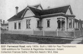
Several houses from this development still survive in the area. The oldest, 1286 Pembroke Street, was built in 1884 and is a simple vernacular building embellished with Italian Villa features. Several of Victoria’s rare brick homes are located in the 1200-1400 blocks of Pembroke, built in 1890-93 by their bricklayer owners. A number of Italianate and Queen Anne cottages date from 1889-1893 (including the one at 2221 Fernwood Road, built originally on Sayward).
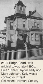
2130 Ridge Road, a two-storey Italianate house built by Icelanders Kelly and Mary Johnson, must have dominated the district with its original tower when it was built in 1893.
Streetcar Lines & Residential Development in the West & Central Areas
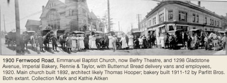
Residential development in Fernwood, as in so many other parts of Victoria, accelerated after the streetcar system was introduced. In 1890 a line was opened along Fort Street to the Royal Hospital (later the Royal Jubilee). In 1891 another line took a more circuitous route into the heart of Fernwood: Pandora Avenue, Cook Street, Caledonia Avenue, Chambers Street and Gladstone Avenue, with the terminus at Fernwood Road. Emmanuel Baptist Church (now the Belfry Theatre, 1900 Fernwood Road) built between 1886 and 1892 and the commercial buildings at the corner of Fernwood Road and Gladstone Avenue (1284 and 1301 , and 1923 and 2008 Fernwood Road) grew up at the end of the line.
The development of the land between Cook and Chambers Streets on part of the old Finlayson Estate and the tract comprising the nursery of George Jay Sr. on the east side of Cook between North Park and Caledonia Streets was also facilitated by the streetcar line. Over two dozen of Fernwood’s Heritage Register houses were built in the period 1890-93 within a few blocks of the streetcar lines, many of them in the fashionable cubical Italianate style.
A particularly striking development was the series of five (originally six) constructed in 1892 by William Whittaker at 1203, 1209, 1213, 1217, and 1221 Yukon Street as rental properties.
In spite of the residential growth of this area, it retained a rugged, rural character for many years. After George Jay Elementary School opened in 1909 the principal complained that wild, horned cattle sometimes stampeded through the school grounds en route to the cattle pound on nearby 1100-block Queens Avenue and to the slaughterhouse at Oaklands.
Residential Development in Eastern Fernwood
Residential development in the eastern portion of Fernwood was slow to take place, perhaps because the
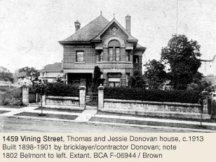
Pearse family wanted to enjoy the sanctity of their estate. Their home, Fernwood, was demolished in the 1960s. Subdivision of the western part of the estate didbegin in the 1890s and some of the first streets to be developed there were Vining Street, Stanley Avenue and Balmoral Road. Six heritage register houses in the 1400 block of Vining were constructed in 1891-92, two of them by builder George Powers. Between 1898 and 1901 bricklayer Thomas Donovan built 1459 Vining Street, an unusual patterned masonry Queen Anne.
Development of the eastern portion of the Fernwood Estate closer to the Pearse home took place in the early 1900s. Although two Queen Anne houses were built earlier on Belmont Street (Warley at 1916 Belmont Avenue in 1893, by Rev. Peter H. McEwen of Emmanuel Baptist Church two blocks away on Fernwood, and Oak Villa in 1891 at 1924 Belmont Avenue), almost all of the construction in this area was done during the boom of 1907-13. As a result there is a sharp divide in the house styles seen in the neighbourhood. This contrast is most dramatic in the 1400 block of Pembroke Street, where the 1891 Italianate 1449 Pembroke Street to the west rubs shoulders with the 1911-12 Arts & Crafts 1461 Pembroke Street to the east. Belmont runs along a ridge that connects to the Rockland area and terminates at Pembroke; the higher ground attracted affluent homeowners who built in the Arts & Crafts style then current in Rockland, including a house (1803 Belmont Avenue) designed by Samuel Maclure.
Fernwood Heritage Register Properties
115 Fernwood properties on the City of Victoria's Heritage Register in 2026
Heritage-designated - Protected by bylaw. Houses eligible for VHF funding.
Heritage-registered - Not protected, may warrant future preservation. Houses ineligible for VHF funding.
Heritage Covenant - Protected by legal agreement. Houses eligible for VHF funding.
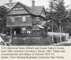
1270 Balmoral Rd
Designated 2012
1324 Balmoral Rd
Designated 2007
1315 Bay St
Designated 2012
1458 Begbie St
Designated 1987
1802 Belmont Av
Registered
1803 Belmont Av
Registered
1811 Belmont Av
Registered
1815 Belmont Av
Registered
1900 Belmont Av
Registered
1916 Belmont Av
Registered
1923 Belmont Av
Designated 2004
1924-1926 Belmont Av
Designated 1991
2024 Belmont Av
Registered
2254 Belmont Av
Designated 2011
1112 Caledonia Av
Designated 1977
1116 Caledonia Av
Designated 2012
2011 Cameron St
Designated 1991
1511 Chambers St
Designated 1979 / Institutional
2008 Chambers St
Designated 2010
1250 Denman St
Designated 2013
1252 Denman St
Designated 2004
1260 Denman St
Designated 2004
1436 Elford St
Designated 2010
1442 Elford St
Designated 2020
1539 Elford St
Registered
1132-34 Empress Av
Designated 2025
1405 Fernwood Rd
Designated 1978
1413 Fernwood Rd
Designated 1978
1417 Fernwood Rd + carriage house
Designated 1996
1418 Fernwood Rd
Designated 1978
1422 Fernwood Rd
Registered
1423 Fernwood Rd
Designated 2001
1621 Fernwood Rd
Designated 2004
1702 Fernwood Rd
Designated 1978
1706 Fernwood Rd
Designated 1985
1295 Gladstone Av / 1900 Fernwood Rd (2 buildings)
Designated 1979
1921-23 Fernwood Rd
Designated 2002 / Commercial
2008-10 Fernwood Rd
Designated 2008 / Commercial / Aptartment
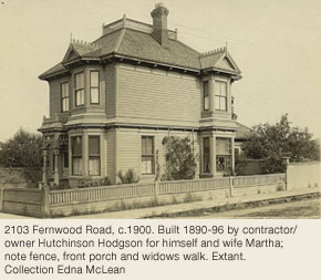
2103 Fernwood Rd
Designated 1976
2221 Fernwood Rd
Designated 1977
2407 Fernwood Rd
Designated 2025
1124 Fort St
Heritage Covenant 1991
1140 Fort St
Designated 1980
1156 Fort St
Designated 1976
1162 Fort St
Designated 1974
1190 Fort St
Designated 1988
1192 Fort St
Designated 1977
1202 Fort St + interiors
Designated 1977
1416 Fort St
Registered
1420 Fort St
Registered
1284-1298 Gladstone Av / 2000-2006 Fernwood Rd
Designated 2014
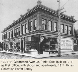
1301-11 Gladstone Av
Registered
1347 Gladstone Av
Registered
1427 Gladstone Av
Registered
1432 Gladstone Av
Registered
1441 Gladstone Av
Registered
1460 Gladstone Av
Registered
1466 Gladstone Av
Designated 2025
1508 Gladstone Av
Designated 1991
1537 Gladstone Av
Registered
1560 Gladstone Av
Designated 2010
1609 Gladstone Av
Designated 1989
1260 Grant St
Registered / Institutional
1349 Grant St
Registered
1421 Grant St + interiors
Designated 2003 including interiors
1448 Grant St
Designated 1990
1449 Grant St
Designated 2011
1334 Johnson St
Designated 1999
2251 Lydia St
Designated 2007
1119 Ormond St
Designated 1995
1342 Pandora Av
Designated 1977
1110 Pembroke St
Registered
1211 Pembroke St
Designated 1977
1215 Pembroke St
Designated 1977
1286 Pembroke St
Designated 1977
1347 Pembroke St
Registered
1360-62 Pembroke St
Registered
1400 Pembroke St
Designated 1991
1414 Pembroke St + garage
Designated 2007
1417 Pembroke St
Designated 1984
1439 Pembroke St
Designated 1992
1444-46-48 Pembroke St
Designated 1997
1449 Pembroke St
Designated 1997
1461 Pembroke St + interiors
Designated 1997
1516 Pembroke St
Designated 1996
1555 Pembroke St + wall
Designated 2001
1561 Pembroke St
Designated 1984
1569 Pembroke St
Designated 1986
1118 Princess Av
Registered / Institutional
2130 Ridge Rd
Designated 1985
1243 Rudlin Street
Designated 2003
1250 Rudlin St
Designated 2002
2226 Shelbourne St
Designated 1996
2213 Spring Rd
Designated 1997
1402 Stadacona Av / 1480 Fort St
Designated 1977
1611 Stanley Av
Designated 2021
1702 Stanley Av
Registered
1834 Stanley Av / 1359 Vining St
Designated 2004
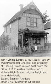
1347 Vining St
Designated 1987
1423 Vining St
Registered
1429 Vining St
Registered
1431 Vining St
Designated 2004
1433 Vining St
Registered
1434 Vining St
Registered
1437 Vining St
Designated 1994
1459 Vining St
Designated 1989
1272 Walnut St + cottage
Designated 2002 including cabin
1276 Walnut St + garage
Designated 2002 including garage
1240 Yates St
Designated 2004
1270 Yates St
Designated 1976
1201-1203 Yukon St
Designated 1985
1209 Yukon St
Designated 2019
1213 Yukon St
Designated 1987
1217 Yukon St
Designated 1994
1221 Yukon St
Designated 1991
North Park
Maryanne McGrath © Victoria Heritage Foundation
North Park is one of Victoria’s oldest residential neighbourhoods, and maintains its historical character of a diverse mixed-use community, bounded by Bay, Blanshard, Cook, and Pandora Streets. This is one of Victoria’s smallest neighbourhoods at one square kilometre or about 18 blocks. It is primarily a residential community, grounded by businesses, recreational facilities, and religious landmarks.
Hudson's Bay Company’s Suburban Five-Acre Lots
The southern portion of the neighbourhood was built on Suburban Five-Acre lots, developed early; this area eventually became the business core of the neighbourhood. They were created as part of the HBC’s early town plans. These lots were not intended to be subdivided for residential use; however their proximity to the townsite contributed to their subdivision within a short period of time. The Colonist advertised lot sales as early as 1864, and by 1872 only four of the 20 five-acre lots remained, while the rest had been subdivided into many small lots. Fire insurance maps from 1885 indicate the area had been developed fairly extensively. In 1890 the electric streetcar line was brought into the area and this accelerated development.
George & Mary Ann Mason’s Early Brick House
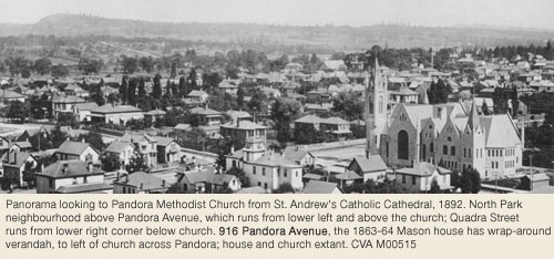
George Mason arrived in Victoria on the Norman Morison in 1851. One of Victoria’s first brick makers, he bought Five-Acre Suburban Lot X in 1856. He built a 2-storey brick residence (916 Pandora Av) on lot 4 of the property, perhaps as early as 1863. An economic downshift forced Mason to sell off most of this property, including the brick house, by 1867.
The street running through the centre of Lot X was named Mason Street, after George Mason. The other half of Mason Street running through Suburban Lot 5 between Quadra and Vancouver was named for Henry Slye Mason, who arrived in Victoria in the 1860s on the Norman Morison. Henry was registrar-general of the Crown Colony of BC before he was called to the BC bar in 1873. In 1870 he married Annie Eliza Thorne, who came to Victoria from England in 1853. These Masons never lived in North Park, but on Government Street (Birdcage Walk) and Dallas Road.
Henry & Sophia Rhodes’s Maplehurst
Henry Rhodes had his magnificent residence Maplehurst built at 1937 Blanshard Street in the early 1860s. Henry, born in London, England, moved to the Sandwich Islands (now Hawaii) in 1845. He came to Victoria with his family on the Eliza and Ella in 1858. Henry served as Hawaiian consul, and in 1875 was appointed Swedish and Norwegian consul. He was also elected to the BC Legislature in 1865. He was a pioneer merchant, and his company was located on Store Street. Henry died at Maplehurst in 1878. His wife Sophia Harriet lived there until her death in 1899. The Rhodes had five daughters and three sons. In 1875 Annie Isabella married Richard William Janion, son of Henry’s old business partner Robert Cheshyre Janion, who built the Janion Hotel in 1891.
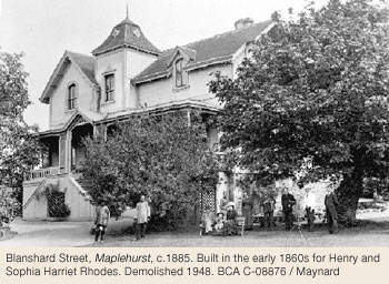
In 1879, youngest daughter Sophia Edith Rhodes married George Anthony Walkem, and he moved into Maplehurst. George came to Canada from Ireland in 1847, and took law at McGill University. He practised in the Cariboo for a number of years, and was elected MLA for the region. In 1874 Walkem was appointed BC’s third premier after De Cosmos resigned. He held the office until 1876, and again in 1878-82. He then returned to law and became Chief Justice of the BC Supreme Court. Sophia died in 1902, George retired in 1903 and died at Maplehurst in 1909. It became a rooming house, and then was demolished in 1948 to make way for the Memorial Arena.
Samuel Thomas Styles & Amelia Street
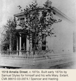
Another early North Park builder was Samuel Thomas Styles, who arrived in Victoria from England c.1870. He and partner John Kinsman established one of the province’s earliest building and contracting firms. Samuel built a series of workers cottages on Amelia Street, the earliest in c.1871 (1519 Amelia St) for himself and his family. Six of these 2-storey cottages remain today, mostly as businesses, but they were rental homes for many years. Styles was responsible for many other early buildings, including the naval buildings in Esquimalt.
Roderick & Sarah Finlayson’s Rock Bay Farm Estate
The northern portion of North Park was developed much later than the southern, because it was originally part of Roderick and Sarah Finlayson’s Rock Bay farm estate, which was bounded by Bay, Government, Chambers and Pembroke Streets. Finlayson, an HBC Chief Factor, was in charge of Fort Victoria from 1844-49. He purchased 103 acres from the HBC in 1851, and built his residence, Rock Bay, in the block bounded by today’s Douglas, Bay and Government Streets, and Queens Avenue. After Roderick’s death in 1892 and Sarah’s in 1906, the estate was subdivided. One of the first things done was blasting the rock for Bay Street between Wark and Quadra Streets. The sale of the subdivided lots was geared towards wage earners and investors, attesting to the area’s eventual development as a neighbourhood for renters and average-income earners.
Apartment Blocks
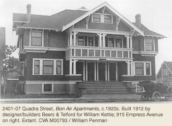
Some of Victoria’s oldest and best apartment blocks are in North Park, some with accommodation for shops on the main level. Several of the blocks have been demolished, but others remain as key elements of the historical residential character of the neighbourhood. The Abbey apartments at 1702 Quadra Street at Fisgard Street were designed by C. Elwood Watkins and built in 1911 for K.J. Lee Dye as shops on the main floor with stables behind and apartments above. The Bon Air Apartments at 2401-07 Quadra Street were built in 1912 for William Kettle, and designed by Beers & Telford. This building is now stuccoed, but retains many of its original features, including its original use as an apartment building. Central Park Apartments at 1010 Queens Avenue was built in 1913-14, for and by Thurston and Johnson Fairhurst from Wigan, Lancashire, England. By 1917 they were in active service, Thurston as a gunner at Signal Hill Battery, Esquimalt. The brick Montana Apartments at 1010 Empress Avenue were built in 1912 for Mrs. Martha J. Muldoon who also owned the James Bay Hotel. In 1912, the Bon Accord Apartments at 845 Princess Avenue were built for Margaret Duncan Christie, who was a Victoria School Board Trustee from 1931 and the first female City of Victoria Councillor from 1944-54. Her daughter Lily Wilson served on Council from 1956-69. Maggie’s husband Alexander was the department manager of Dixi H. Ross & Co on Government Street. The family lived at 1296 Richardson Street for many years. Funeral parlour proprietor Mason Sands commissioned Johnson & Stockdill to build the Sandholme Apartments at 2450 Quadra Street in 1941.
Institutional & Recreational Facilities
Many homes were built in North Park from 1907 until the beginning of WWI, coinciding with Victoria’s greatest building boom, although the market had begun to collapse by 1913. The neighbourhood was close to downtown and City Hall. Several new schools were built nearby, including George Jay Elementary (1118 Princess Av, Fernwood, 1909), and the many churches of various denominations along Quadra Street (three of them detailed in This Old House Three) drew residents into the area. North Park was and is Victoria’s recreational hub, with Royal Athletic Park, Central Park and the Crystal Pool, the Curling Club, and the Save-on-Foods Memorial Centre (formerly the site of the Memorial Arena).
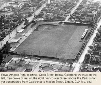
The City of Victoria acquired Central Park, an 8-acre parcel of land, from the Finlayson Estate in 1906. The city’s second oldest park, it is still used for ballgames and other community events. Royal Athletic Park (RAP) had been used as a playing field since about 1902, and for professional baseball since 1908, although it was private land in the estate of Grace Parshalle until the City purchased it in 1925 for about $30,000. Since then, various improvements have been made to serve the community’s needs, with extensive restoration after a 1967 fire. In 2007 RAP was the site of Group F of the Under-20 World Cup of Soccer games. The Memorial Arena, affectionately known as the “Barn on Blanshard,” was built in 1948 and served Victoria for nearly 60 years until it was replaced by the Save-on-Foods Memorial Centre, completed in 2005. The Curling Club was built in 1952, to supplement the Memorial Arena. The Crystal Pool, designed by architect John Di Castri, was built in 1971. For many years it was Victoria’s only Olympic-sized swimming pool.
Chinese Residents
Many homes were built in North Park from 1907 until the beginning of WWI, coinciding with Victoria’s greatest building boom, although the market had begun to collapse by 1913. The neighbourhood was close to downtown and City Hall. Several new schools were built nearby, including George Jay Elementary (1118 Princess Av, Fernwood, 1909), and the many churches of various denominations along Quadra Street (three of them detailed in This Old House Three) drew residents into the area. North Park was and is Victoria’s recreational hub, with Royal Athletic Park, Central Park and the Crystal Pool, the Curling Club, and the Save-on-Foods Memorial Centre (formerly the site of the Memorial Arena).
The City of Victoria acquired Central Park, an 8-acre parcel of land, from the Finlayson Estate in 1906. The city’s second oldest park, it is still used for ballgames and other community events. Royal Athletic Park (RAP) had been used as a playing field since about 1902, and for professional baseball since 1908, although it was private land in the estate of Grace Parshalle until the City purchased it in 1925 for about $30,000. Since then, various improvements have been made to serve the community’s needs, with extensive restoration after a 1967 fire. In 2007 RAP was the site of Group F of the Under-20 World Cup of Soccer games. The Memorial Arena, affectionately known as the “Barn on Blanshard,” was built in 1948 and served Victoria for nearly 60 years until it was replaced by the Save-on-Foods Memorial Centre, completed in 2005. The Curling Club was built in 1952, to supplement the Memorial Arena. The Crystal Pool, designed by architect John Di Castri, was built in 1971. For many years it was Victoria’s only Olympic-sized swimming pool.
Businesses & Funeral Parlours
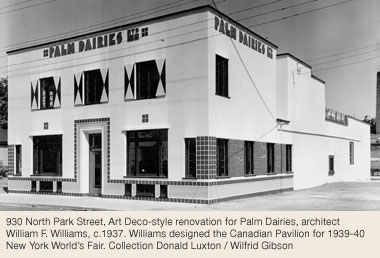
North Park has been home to several prominent businesses. Chinese-owned laundries were prolific in the area in the early 1900s. Palm Dairies was located at 930 North Park Street from 1930 through the 1960s. Beatrice Foods Inc bought out the Prairie-based company in 1990. David William Hanbury operated the Golden West Bakery at 2120 Quadra Street c.1911 until the late 1920s, when his son Evan Hughes Hanbury took over operations. He sold it to McGavin’s Bakery c.1938, and continued managing it for many years. Well-known Victoria contractors Luney Brothers had a shop and building yard where Island Farms and John’s Noodle Village are located today.
This neighbourhood was home to an unusually high number of funeral parlours. Two prominent examples were Thomson and Sands. The Thomson Funeral Home was located at 1625 Quadra Street by 1921. Proprietor Frank Landon Thomson worked with William James Hanna in 1914, and by 1917 had established his own business on Pandora Street before moving to the North Park neighbourhood several years later.
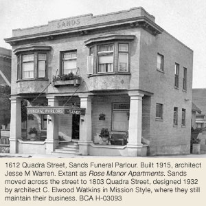
Mason “Pops” Sands founded Sands Funeral Parlour in 1913, when he bought out the shares of his business partner, Mr. Fulton. They had established a small funeral parlour at 1515 Quadra Street in 1912. Booming business necessitated a move to a larger building at 1612 Quadra Street, which is now the Rose Manor Apartments. The business moved in 1a933 to 1803 Quadra Street, designed in the Spanish Mission style by architect C. Elwood Watkins. Sands now has four funeral chapels on Vancouver Island.
Street Names & Boulevard Trees
The neighbourhood’s street names reflect its historical character. Many of them changed in 1907, along with Victoria’s street-numbering system. Chatham was changed to Caledonia Street, Pioneer to North Park Street, and Farquhar/Mason/St. Louis to Mason Street at this point. Balmoral Road was not adopted until about 1920, when residents petitioned the City to change the street’s name from Fisgard, saying that it was not an appropriate name for their neighbourhood. Wark Street was named for Hudson’s Bay Company (HBC) Factor and pioneer John Work of Hillside Farm. John adopted Work, the anglicized version of the Irish Wark, when he joined the HBC. The street, originally named Work, was later changed to Wark. City Archivist Ainslie Helmcken (1015 Moss St, Rockland) was responsible for naming Dowler Place in 1969, after an 1890s North Ward schoolteacher. Her brother Wellington was a Victoria city clerk from 1888 to 1918. He lived on Blanshard Street near Caledonia.
The boulevard trees, many planted in the 1920’s and ’30s, include: early-flowering Purple-Leaved Plum on Princess Avenue and on Vancouver Street north of Queens Avenue; Double White Hawthorn on Queens, which is joined by Schwedler’s Norway Maple west of Quadra Street; and False Acacia, Sycamore Maple, London Plane and Doubleflower Chestnut on Vancouver Street by Central Park. In the 1950s Cockspur Hawthorn and Silver Birch were planted on Empress Avenue.
Heritage Register Properties
32 North Park properties on the City of Victoria's Heritage Register in 2026
Heritage-designated - Protected by bylaw. Houses eligible for VHF funding.
Heritage-registered - Not protected, may warrant future preservation. Houses ineligible for VHF funding.
Heritage covenant - Protected by legal agreement. Houses eligible for VHF funding.
1519 Amelia St
Registered
1521 Amelia St
Registered
1525 Amelia St
Registered
1527 Amelia St
Registered
1529 Amelia St
Registered
1701 Quadra St / 932 Balmoral Rd
Designated 1979
968 Balmoral Rd
Designated 1983
1005 Balmoral Rd
Heritage Covenant
1609 Blanshard St
Registered
919 Caledonia Av
Designated 2019
929 Caledonia Av
Designated 2000
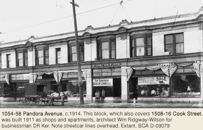
1050-58 Pandora Av / 1508-16 Cook St
Designated 2020
836 Cormorant St
Registered
840 Cormorant St
Registered
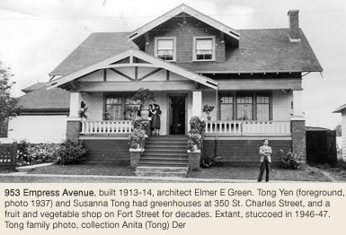
953 Empress Av
Designated 1990
1026 Empress Av
Designated
955 North Park St
Designated 1981
916 Pandora Av
Registered
1030 Princess Av
Registered
1034 Princess Av
Designated 2006
1040 Princess Av
Registered
1042 Princess Av
Designated 2000
1054 Princess Av
Registered
1600-02 Quadra St
Heritage Covenant
1611 Quadra St
Designated 1979
1701 Quadra St / 932 Balmoral Rd
Designated 1979
2303 Quadra St
Registered
2309 Quadra St
Designated 1995
1029 Queens Av
Registered
1033 Queens Av
Registered
2117 Vancouver St
Registered
2201 Vancouver St
Designated 2007
2209 Vancouver St
Designated 2007
Downtown
In 2022, the City of Victoria revised its neighbourhood planning boundaries. The Fairfield and North Park neighbourhood boundaries were adjusted. The former Harris Green neighbourhood is now considered a district within the Downtown neighbourhood.
The Victoria Heritage Foundation’s research is limited to houses that were originally designed as single-family. There are currently three such houses on the Downtown Heritage Register. The history of the former Harris Green neighbourhood remains here for reference.
Photos and limited information on other properties on the Downtown Heritage Register can be found on VHF’s GIS map. The Victoria Civic Heritage Trust administers the grant programs for heritage designated commercial, industrial, institutional and historic apartment buildings – most of which are located Downtown.
Harris Green (now part of Downtown)
By Maryanne McGrath © 2007 Victoria Heritage Foundation
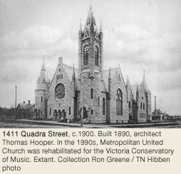
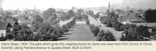
Harris Green is Victoria’s smallest neighbourhood, comprising just 12 blocks. Although it began as a residential neighbourhood, for years it was primarily a commercial district, but recent condominium developments are bringing residents back to the area. Pandora Avenue, Cook Street, and Meares Street bound the area, and its westerly boundary is between Quadra and Blanshard Streets. The neighbourhood’s name originated from a strip of parkland that runs along Pandora Avenue from Quadra Street to Chambers Street, named after Thomas Harris, Victoria’s first mayor (1862-65). The neighbourhood’s northern border boasts several noteworthy churches, including the visually prominent Metropolitan United Church (1411 Quadra Street).
This community has undergone the most significant transformation of any Victoria neighbourhood, other than downtown, reflecting its proximity to downtown. The area developed early, and the sections nearest Quadra and Blanshard Streets were first built up primarily as single family housing for downtown workers. Fire insurance maps from 1885 also indicate orchards and a few small commercial establishments in the area. Dwellings were concentrated along the west border nearest the downtown core.
Early Commerce, Industry & Sports
The City operated stables on Yates Street by 1890, which eventually became a general City Yard. It remained here until the late-1940s. Judah P. Davies had cattle auction yards between (it is thought) Fort and View Streets; Christopher Morley's first soda water factory was near the corner of Yates and Cook Streets; the Bavaria Brewery was on Fort Street; and the Victoria Electric Light Works was on View Street. Livery stables, hack drivers and blacksmiths had begun to be replaced in the neighbourhood by automobile companies and garages by WWI. Moore & Whittington Lumber Company had offices at 865 (originally 159) Yates Street from 1902-1911. By 1912 they had moved to Bridge Street in Burnside. BC Steam Dye Works was located at 831 (originally 141) Yates Street from the early 1890s until c.1920.
A large indoor roller skating rink built on Yates Street near Quadra Street in 1885 was seized by the City for unpaid taxes, bought by M. King and torn down in 1890 to make way for two rental houses. The Victoria Assembly Rooms were built at 938 (originally 178) Fort Street near Vancouver Street in 1886. Many of Victoria’s elite attended dances there. In 1907 it was converted to a roller skating rink, but was demolished by 1912.
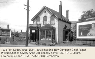
Victoria’s Last HBC Chief Factor
One of the area’s earliest residences still stands at 1038 (originally 216) Fort Street as an antique shop on the “Antique Row” area of Fort Street. According to tax assessment rolls, William Pickett built the house in 1866 and William Charles (1831-1903) acquired it two years later. Son of HBC Chief Factor John Charles, William was born and educated in Scotland. In 1853 he joined the HBC at Fort Vancouver, WA, as an apprentice clerk, then was transferred to Fort Hall, Idaho. He was sent to Fort Victoria in 1858, where he married Mary Ann Birnie, daughter of HBC officer James Birnie. In the 1860s Charles worked in the BC Interior but returned to Victoria in 1870 and worked under his brother-in-law, James Allen Grahame (534 Street Charles St, Rockland). In 1872 he was promoted to factor, and in 1874, chief factor. In 1883 Charles became the first chairman of the newly organized Canadian Pacific Navigation Co. He retired to Victoria in 1885, but two years later suffered a bout of debilitating paralysis. He died in 1903 and Mary Ann remained in this house until 1912.
Early Business Family Residents
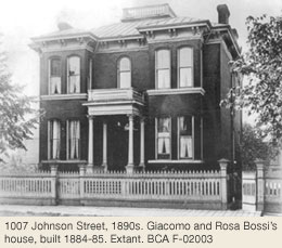
The 1884-85 Giacomo Bossi (merchant, supplier and landowner) home at 1007 Johnson St serves as a reminder of Harris Green’s residential roots. During the 1890s many more dwellings appeared in the area, and several of Victoria’s prominent early families resided here. It was a logical choice for businessmen as its proximity to downtown allowed for ease of accessibility to their growing establishments.
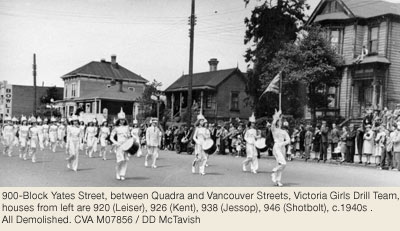
Several business and professional families have had a long history with Harris Green. These include the German-born Leiser family: Gustav and Meier “Max” Leiser, brothers of Simon Leiser (1005 St Charles St), and Gustav's wife Sophia (1862-1919) lived at 920 Yates Street (originally 178, built c.1891, demolished 1951) for some years. Gustav (1856-1896) formed Lenz & Leiser with Jacob Lenz, his father-in-law, in 1884, to sell dry goods and mens wear, on Yates Street. Next door on Yates, Max Leiser (1861-1935), who married his brother's widow Sophia after Gustav died, ran a wine and liquor business with Luke Pither until bought out in 1910 by the Guinness family for $1-million.
James “Charles” Comyns Kent (1839-1922) and his wife Ellen (1831-1918), parents of prominent musician Charles Herbert Kent (228 Douglas St), lived at 926 (originally 180) Yates Street for many years (built c.1870, demolished 1951). It was called Rose Garden because of its magnificent garden. Charles operated a hardware store on Fort Street, where the Pemberton Block is today. He eventually became City Treasurer, until retiring at 70.
John Jessop (1829-1901), a pioneer teacher in the city, lived at 938 Yates Street for 30 years (built c.1870, demolished by 1950.) Born in the UK, he took teacher training in Toronto and (after a brief stint in the Cariboo gold rush) began teaching here in 1864, when free education was introduced. In 1872 became the first Superintendent of Schools. In 1868 he married Margaret Fausette (1837-1897), who arrived in Victoria on the “bride ship”, SS Tynemouth.
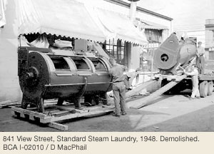
The Savage family had several generations of history in Harris Green. Robert William Savage (1839-1906) arrived with his parents on the Norman Morison in 1853. By the early 1870s, he and wife Jane (Omash, 1851-1923) were living on Johnson Street, and in 1885 built 1103 View (demolished 1962 for the Cook Medical Bldg). His jobs included teamster and janitor. Son Henry Richard Savage (1873-1950) and family lived at 944 Johnson Street (built c.1909). Henry founded the Standard Steam Laundry (841 View Street), c.1905, a neighbourhood fixture for some 60 years until bought by Canadian Linen Supply Co in 1963.
The Todd Family & 952 Johnson Street
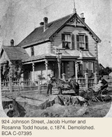
The Todd family owned the north side of Johnson Street between Quadra and Vancouver Streets for many years. Jacob Hunter Todd (1827-1899) came west in 1862 with his children Sara (638 Rockland Pl) and Charles (1041 St Charles St, Rockland). In 1874 he established the Horseshoe brand salmon-canning business at Yates and Wharf, and built Fairview House (with an unobstructed view of the Olympic Mountains) at 924 Johnson Street (architect Thomas Trounce, demolished by 1921) for his second wife Rosanna Wigley (1838-1931, 1525 Shasta Pl, Rockland), who lived there until 1904.
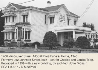
Son Charles joined the canning business, and built 952 Johnson Street (architect Samuel C. Burris) in 1884 when he married Louisa Norris; in 1904 they moved to Rockland. Another son, Bert Todd, had the October Mansion Apartments (This Old House Four) built in 1910 (extant) on Cook Street, between Fort and Meares Streets, by George Mesher as a wedding present for his wife Ada (721 Linden Av, Rockland).
Fairview House was home to numerous families over the next 15 years, including Rosanna's daughter May and her husband J. Hebden Gillespie, (son of George and Florence Gillespie, 1021 Gillespie Pl, Rockland), secretary-treasurer of Plimley Automobile Company. The house was demolished by 1921, likely to accommodate an automobile business.
Another prominent local entrepreneur was Lee Mong Kow. He lived at 952 Johnson Street until c.1920. Kow built several substantial Chinatown buildings (including stores on Fan Tan Alley –1901, Thos. Hooper), while working for 45 years with Customs & Immigration. He moved back to Hong Kong as chief Chinese agent of the Pacific Steamship Co, but was killed in a car accident in 1924 at 63. By 1924, McCall Bros had established a funeral parlour at 952 Johnson, which became 1400 Vancouver Street c.1942. The house was demolished for office space in 1959, but some of its leaded glass was salvaged and re-used in the present building.
Arrival of the Automobile Dealers and the 1920s
Changes to Harris Green occurred slowly. As downtown living became unfashionable for Victoria’s elite who moved to more distant neighbourhoods such as Rockland, smaller single family dwellings were constructed, and existing large houses were converted to boarding houses, then torn down and replaced with businesses and lower income housing. Downtown expansion also began, bringing more commercial buildings to Harris Green. Many older homes were demolished starting in the 1920s, and by the 1930s the neighbourhood had become home to many automobile dealers.
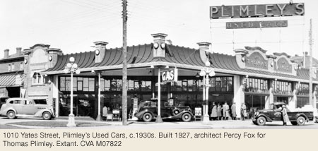
Plimley’s Used Cars at 1010 Yates Street, which conveniently also sold gas and was one of the most prominent of these dealerships, remained in the neighbourhood until the 1970s.
The Begg Motor Company, in the 800 and 900 Blocks of View Street for a number of years, was managed by Jim Wood (2667 Empire St) during the 1920s. Wilson Motors on Pandora formed the basis of the Wilson Centre, now Harris Green Village. A number of car dealerships still exist in the eastern section of Harris Green.
1960s to the Present
During the 1960s and 1970s, many rental projects for moderate to low income families were constructed in Harris Green. Examples are View Towers at 1147 Quadra Street, and The Chelsea at 865 Yates Street. Today the area has become popular with condominium developers whose luxury buildings are bringing higher income earners closer to the downtown core.
Heritage Register Properties
3 Downton (originally single-family) properties on the City of Victoria's Heritage Register in 2026
Heritage-designated - Protected by bylaw. Houses eligible for VHF funding.
Heritage-registered - Not protected, may warrant future preservation. Houses not eligible for VHF funding.
Heritage covenant - Protected by legal agreement. Houses eligible for VHF funding.
865 Academy Close
Designated 2009
1030 Cook St
Designated 2012
840 Fort St
Designated 2018
1023-25 Fort St
Registered
1007 Johnson St
Designated 2006
522 Quadra St
Designated 1984
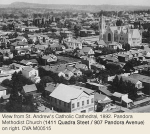
1411 Quadra St/907 Pandora Av
Designated 1979
Rockland
by Carey Pallister © 2005
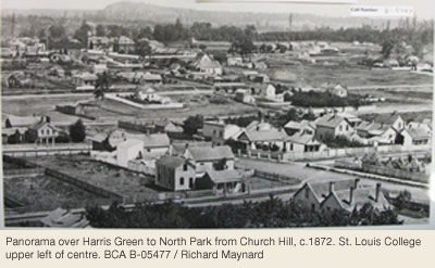
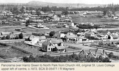
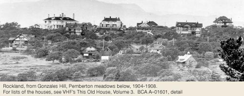
The neighbourhood known today as Rockland comprises an area bounded by Fort Street to the north, Richardson Street to the south, Linden Avenue to the west and Richmond Road to the east. Long before it was named, it was identified as a desirable place to live by Joseph Despard Pemberton, the first colonial land surveyor. Pemberton owned most of the easterly portion of what is now Rockland (Section 74), while the westerly section was subdivided from lands owned by Governor James Douglas (Fairfield Farm Estate). The open landscape offered spectacular views over Fairfield, the Strait of Juan de Fuca, the Olympic Mountains, Mt. Baker and the growing city centre. Oak trees and the rich blue of camas flowers characterized the area, which was rocky and steep in places. Early settlers referred to Rockland as Government Hill or Nob Hill. A panorama taken from Gonzales Hill in 1888 shows a bucolic landscape dotted with a few homes, with cows and sheep grazing in fenced pastures.
First Subdivision
In April 1865 the first subdivision plan for part of what we now call Rockland was deposited with the Land Registry Office. The subdivision consisted of nine lots of about two acres each, on Fort Street between what is now Pemberton Road and Pentrelew Place. The lots were split off from the NE corner of the Douglas Estate. Members of the merchant class such as brewer Charles Gowen, “Cracker King” Samuel Nesbitt and general merchants Steimler & Weiler purchased these lots, some to build homes, others for investment.
Joseph D. Pemberton built one of the first homes in the area, naming it Gonzales. It was located just SE of where Rockland Avenue and St. Charles Street meet today. Originally built in 1858, the house was added to over the years. Gonzales was demolished in 1952.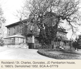
Other early homes included The Winds (demolished) built by Thomas Lett Stahlschmidt next door to Cary Castle in the 1860s. Entrepreneur Robert Burnaby, for whom Burnaby, BC is named, commissioned Charles Verheyden to design a “substantial villa” at the corner of Fort and Moss Street in 1872 which was described in the newspaper as being “remarkably pretty” (demolished). And across the street, Judge Hamilton Gray built a villa residence in 1873 on a five-acre parcel that he purchased from his neighbour Burnaby. Also in 1872, the Bank of British Columbia acquired property from Sir James Douglas off Moss Street between Fort Street and Rockland Avenue, and bank manager William Curtis Ward and his wife Lydia were able to have a large, handsome home built in time for the birth of their first child that year. They called the house Highwood (1021 Gillespie Pl).
Vice Regal Mansion
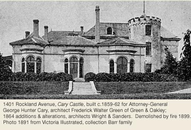
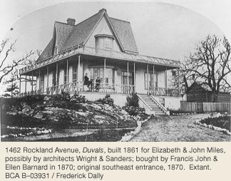
Perhaps the best known early home in Rockland was Cary Castle, designed in 1862 by F.W. Green of Green & Oakley for colonial Attorney-General George Hunter Cary. Cary’s ownership was brief. Following her husband’s untimely death, Elizabeth Miles purchased the rustic stone building with a 3 storey crenellated tower, across the street from Duvals, a lovely Gothic cottage she and her husband John Miles built in 1861 (1462 Rockland Av).
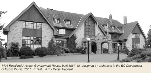
Cary Castle became the official home of the Governor of the Colony of Vancouver Island in 1865, after Arthur Edward Kennedy took a liking to the odd stone house and purchased it from Elizabeth. Cary Castle was altered and expanded to accommodate a succession of Governors and Lieutenant-Governors but it was ultimately destroyed by fire on 18 May 1899.
Government House was rebuilt to designs by Samuel Maclure and Francis Rattenbury and was completed in late 1903. On 15 April 1957 disaster struck again when the 54-year-old building was destroyed by fire. The new building was designed by architects from the BC Department of Public Works and finished in 1959 (1401 Rockland Av).
Grand Homes
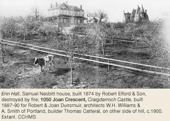
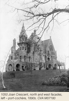
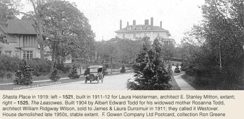
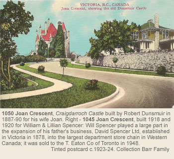
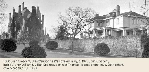
The 1880s saw the construction of larger and grander homes. Samuel Nesbitt, purveyor of crackers to the Navy, chose builders Robert Elford & Son to build Erin Hall off Fort Street in 1874 (demolished). In September 1872, also on Fort Street, Henry Pering P. Crease and his family moved into their Italianate villa, Pentrelew (demolished), a home he had purchased from E.G. Alston in 1871. They were soon joined by more of Victoria’s prominent citizens, such as Rout Harvey, manager of Turner-Beeton, who built Stoneyhurst in 1884. This simple 2-storey frame home next door to Government House commanded excellent views over Fairfield and beyond (1369 Rockland Av -extensively altered). In 1889, banker Alexander A. Green had W. Ridgway Wilson design Gyppeswyk on Moss Street (now Art Gallery of Victoria, 1040 Moss St). Robert and Joan Dunsmuir’s Craigdarroch, built between 1887 and 1890 and set on 28 acres, was the grandest of them all (1050 Joan Cr).
Gardens
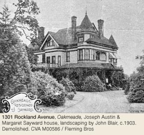
From the 1870s until the turn of the century, many lavish and some modest homes were added to the Rockland landscape. Generally situated to take full advantage of the wonderful views, many of the homes were surrounded by professionally landscaped gardens, although the properties were so large that the natural terrain, flora and trees were allowed to co-exist with the imported varieties of plants. Lumberman Joseph Sayward, for example, hired Beacon Hill Park planner John Blair to landscape his property Oakmeade at 1301 Rockland Avenue (demolished). These gracious homes and their gardens were the venues for lavish parties, musical soirées, dance recitals, weddings and charity events. In 1884, David W. Higgins, editor of the Daily Colonist, commissioned Portland architect H.H. Leslie to design a large home in the latest style.
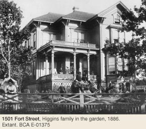
The Higgins’ imposing Italianate villa, Regents Park, was built on the SE corner of Fort and St. Charles Streets (1501 Fort St). Five years later Higgins subdivided his 14-acre property into 20 lots. T.S. Gore, Dominion Land Surveyor, surveyed the Regent’s Park subdivision. The area had been known as Regent’s Park as early as 1863 when Pemberton, possibly trying to lure buyers of the right class, used the name of this up-market London residential area to attract potential buyers. Two new streets, named for Higgins’ children, were created as part of this subdivision: Paul Lane (now Verrinder Avenue) and Maud Street. By 1900, diminishing lot sizes heralded a new generation of owners and homes. The homes were as grand as those of earlier days, but situated on less property and therefore lacking the country estate atmosphere that set Rockland apart from the other residential areas.
Craigdarroch
Eventually, the Craigdarroch Park Subdivision brought the greatest changes to the Rockland neighbourhood. After the death of Joan Dunsmuir in 1908, family lawyer Griffith Hughes presented a plan to the family that would divide the 28-acre property into 144 lots to be sold by lottery. Tickets were sold for $2,750 each, and lots were assigned by draw. The draw took place in March 1910 and by 1911 building in the subdivision began in earnest. Three new streets were created: Joan Crescent, Manor Road and Craigdarroch Road.
Street Names
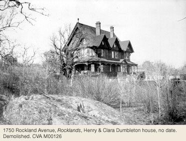
Historically, Belcher Avenue provided access from Cook Street to Pemberton Road, ending at the gates of the Pemberton farm Gonzales. J.D. Pemberton named the street in 1860 for Capt. Sir Edward Belcher, a noted surveyor and explorer, as part of his “Arctic Explorers” group of streets. In the late 1880s, a street connecting Oak Bay Avenue to Henry Dumbleton’s home Rocklands (1750 Rockland Av, demolished) was established; it became Rockland Avenue. In 1905, the section between Pemberton Road and Dumbleton’s house was dedicated as road and the entire street from Cook Street to Oak Bay Avenue was renamed Rockland Avenue.
Other streets in the neighbourhood reflect the names of early residents: Pemberton Road for Joseph Despard Pemberton and Despard Avenue for his grandson who was killed in WWI; Angus Road for James and Forrest Angus (1321 Rockland Av), brothers of R.B. Angus of the CPR; and Joan Crescent for Joan Dunsmuir, wife of coal baron and Esquimalt and Nanaimo Railway builder Robert Dunsmuir. George Gillespie, after whom Gillespie Place was named, was a manager at the Bank of British Columbia and lived at Highwood.
Other streets remind us of grand homes such as Pentrelew Place for the home of Judge Henry P.P. Crease (1201 Fort St, demolished); Algoa, the home of Cuyler A. Holland (1629 Rockland, demolished), and Dereen Place after the Robert and Patience Day home (806 Dereen Pl). Patly (1617 Rockland Av), the James Mitchell house, gave its name to Patly Place and the massive shingle-style home of Thomas B. Hall, a rice mill owner, is remembered in Robleda Crescent (1337 Rockland Av), original house destroyed by fire).
Schools
As the popularity and practicality of operating large estates dwindled, some of the bigger homes were opened as exclusive schools. One of the first was Cloveley College which opened in 1898 at 69 Belcher Street (later 1157 Rockland Av), an area now considered Fairfield Neighbourhood). This grand residence, built in 1884, was originally the home of Thomas and Caroline Humphreys. Following her husband’s death, Mrs. Humphreys leased the building and 1¼ acres of grounds to a succession of schools, but the property will be best remembered for its time as the Collegiate.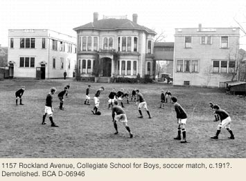
Robert Ward’s home The Laurels at 1249 Rockland Av was also occupied by the Collegiate School from 1903-1912. St. George’s School for Girls then occupied the house until 1928.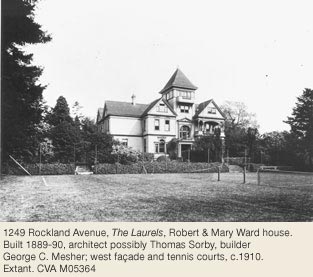
Other schools operated in the neighbourhood include Stoneyhurst University School at Stoneyhurst, 1369 Rockland Av; Westerham School at 1765 Rockland Av; Norfolk House School which used 615 St. Charles Street (Gonzales) as a girls dormitory; the University School (later St. Michael’s) at the corner of Oak Bay and Richmond Avenues; and Victoria College (an affiliate of McGill University), which occupied Craigdarroch Castle from 1921 to 1946.
Watertower
With Victoria’s population growing rapidly, the city water supply was quickly becoming inadequate, and 1909 saw construction of a 100,000-gallon concrete water tower. This must have seemed unsightly, among the villas and Garry oak meadows at one of the highest points of Rockland, but, along with the Smith Hill Reservoir, it constituted a stop-gap project to supply Victorians with water until the new system at Sooke Lake was built. The area around the water tower was known locally as Observatory Hill.
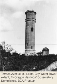
It featured a large, Queen Anne house called Observatory Villa with a 3-storey tower and a small observatory, which was built by amateur astronomer Oregon Columbus Hastings in 1890 (915 St. Charles Street, demolished). By 1903, the lane leading to the observatory had been officially named Observatory Hill.
Seeds and Soda Water
Established as a residential neighbourhood, Rockland has for the most part remained so, apart from a couple of businesses that managed to coexist with Victoria’s elite. For many years, P.T. Johnston’s Seed and Flower Nursery was located on 4½ acres at the SW corner of St. Charles and Fort Streets. Philip Johnston and Henry Mitchell, advertising themselves as seedsmen and florists, started the business in 1868, a year later purchasing their land on Fort Street (then Cadboro Bay Road), which was then outside City limits. Mitchell and Johnston remained in business together until 1874. Mitchell subsequently pursued the field of landscape design while Johnston carried on as P.T. Johnston & Co. His son Robert eventually took over the business. In 1890, Johnston began subdividing the property. Four lots on Fort Street and one on St. Charles Street were sold first; then in 1899 he laid out and sold nine more lots on St. Charles Street.
Finally, in 1904 he sold off another 1½ acres. The business survived in its original location until 1905 and then moved further east on Cadboro Bay Road, near Willows Fairgrounds. In 1902 the Hopkins & Hopkins Carnation Co, “Growers of hothouse products; carnations, violets, asparagus etc,” established greenhouses on the same block. Philip Johnston died in 1912, one year after he retired from 43 years in the nursery business. The only other industry in Rockland was established at the very periphery of the neighbourhood. The Crystal Spring Soda Water Manufacturing Co. had premises at 1244 Richardson Street. The business began in 1913 as the Crystal Springs Supply Co., successors to Christopher Morley who had operated a soda water factory on Waddington Alley. Their source was a spring at the rear of the property that is still active today. They advertised themselves as manufacturers of aerated and mineral water, fruit cordials, fruit syrup and essences. After 42 years in business, the Crystal Springs Beverage Co. moved its operation out of Rockland, to 540 John Street.
Historical Significance
By the 1930s, Victoria City Council recognized that both Rockland and Fairfield had significant heritage value and should therefore be exempt from “any sort of apartment development.” A 1943 bylaw restricted Rockland to “single family, no exceptions, development” but despite these edicts, that era saw significant changes to the neighbourhood as many of the large homes were broken up into apartments, boarding houses and nursing homes.
But it wasn’t until the 1960s that the demolition of houses began, with new subdivisions and streets cutting through old gardens and orchards. In 1970, City staff wrote the first Rockland report. It discussed planning and zoning issues as well as laying out strategies for revitalizing Rockland’s heritage character. Today some of the large homes previously broken up into suites have been returned to single-family dwellings, and many more have been lovingly restored and have opened their doors as bed & breakfast accommodation. To this day Rockland remains one of the most visited and desirable residential neighbourhoods in the city.
Heritage Register Properties
100 Rockland properties on the City of Victoria's Heritage Register 2026
Heritage-designated - Protected by bylaw. Houses eligible for VHF funding.
Heritage-registered - Not protected, may warrant future preservation. Houses ineligible for VHF funding.
Heritage covenant - Protected by legal agreement. Houses eligible for VHF funding.
NHS - National Historic Site
1064 Beverley Pl
Registered
1008 Carberry Gardens
Designated 2000
1372 Craigdarroch Rd
Registered
806 Dereen Pl
Registered
1177 Fort St/1043-45 Linden Av
Designated 1977
1195 Fort St
Designated 1977
1501 Fort St
Designated 1974
1015 Gillespie Pl
Registered
1021 Gillespie Pl
Registered
1007 Joan Cr
Registered
1045 Joan Cr
Registered
1050 Joan Cr
Designated / NHS 1992
1069 Joan Cr
Designated 1986
1070 Joan Cr
Registered
1091 Joan Cr
Registered
721 Linden Av
Registered
805 Linden Av
Designated 1978
809 Linden Av
Registered
903 Linden Av
Designated 1995
911 Linden Av
Designated 1988
548 Lotbinière Av
Registered
1022-24 McGregor Av
Registered
1032 McGregor Av
Designated 1984
1385 Manor Rd
Designated 1991
1521 Montgomery St
Registered
1015 Moss St
Designated 2012
1025 Moss St
Registered
1040 Moss St
Registered
1057 Moss St
Designated 2010
729 Pemberton Rd
Registered
750 Pemberton Rd
Designated 2001
834-36 Pemberton Rd
Registered
852 Pemberton Rd
Registered
855 Pemberton Rd
Registered
906 Pemberton Rd
Designated 2001
1016 Pemberton Rd
Registered
1320 Purcell Pl
Registered
1502 Regents Pl
Designated 1988
1520 Regents Pl
Registered
1249 Rockland Av
Registered
1320 Rockland Av
Designated 1985
1321 Rockland Av
Registered
1322 Rockland Av
Heritage Covenant
1337 Rockland Av
Registered
1369 Rockland Av
Registered
1373 Rockland Av
Registered
1377 Rockland Av
Registered
1385 Rockland Av
Registered
1393 Rockland Av
Registered
1401 Rockland Av + outbuildings
Registered / National Historic Site 2002
1401A Rockland Av
Registered
1442 Rockland Av
Registered
1462 Rockland Av
Registered
1470 Rockland Av
Designated 2000
1509 Rockland Av
Designated 2000
1564 Rockland Av
Registered
1595 Rockland Av
Registered
1598 Rockland Av
Registered
1617 Rockland Av
Registered
1618 Rockland Av
Designated 2001
1630 Rockland Av
Designated 1997
1648 Rockland Av
Registered
1715 Rockland Av
Designated 1986
1737 Rockland Av
Designated
1745 Rockland Av
Designated 2010
1759 Rockland Av
Designated 1988
1765 Rockland Av
Registered
1770 Rockland Av
Designated 1982
638 Rockland Pl
Designated 2000
1521 Shasta Pl
Designated 1987
1524 Shasta Pl
Designated 2000
520 St. Charles St
Designated 2001
522 St. Charles St
Designated 2024
528 St. Charles St + interiors
Designated 2003 including interiors
534 St. Charles St
Designated 1985
582 St. Charles St
Designated 2002
610 St. Charles St
Designated 1987
620 St. Charles St
Designated 1997
800 St. Charles St
Registered
811 St. Charles St
Designated 1985
830 St. Charles St
Registered
906 St. Charles St
Registered
908 St. Charles St
Registered
914 St. Charles St
Designated 1999
937 St. Charles St
Registered
943-947 St. Charles St
Registered
942-44 St. Charles St
Designated 2001
1005 St. Charles St
Registered
1020-22 St. Charles St
Designated 2004
1023 St. Charles St
Designated 1996
1041 St. Charles St + interiors
Designated 1980
1646 St. Francis Wood
Designated 2002
1000 Terrace Av
Registered
1001 Terrace Av
Designated 1985
1004 Terrace Av
Registered
1009 Terrace Av
Designated 1986
1030 Terrace Av
Registered
1031 Terrace Av
Registered
1075 Verrinder Av
Registered
James Bay
By John Adams ©
Victoria’s most distinct neighbourhood geographically is James Bay, a peninsula with Beacon Hill Park on the east, the Inner Harbour on the north, Outer Harbour on the west and Strait of Juan de Fuca on the south. Compared with other neighbourhoods in Victoria, James Bay is relatively flat, but undulates gently. The soil is predominantly deep loam except for a few outcrops of bedrock on the shoreline. Its only prominent watercourse was Providence Pond (near the corner of Oswego Street and Superior Street), a swampy lake emptied by a stream that flowed into Major Bay (where Fisherman’s Wharf Park is now).
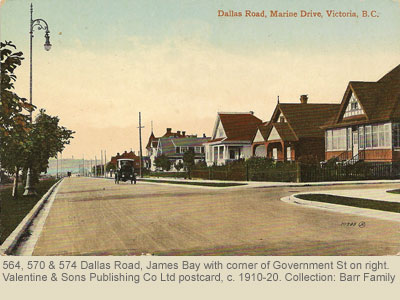
First Nation Residents, the Hudson’s Bay Company & James Bay
James Bay derives its name from the body of water, named in honour of Sir James Douglas, which was a shallow tidal inlet extending from what is now called the Inner Harbour eastward almost to Blanshard Street, encompassing the present site of the Empress Hotel, Victoria Conference Centre and Crystal Garden. After Fort Victoria was built in 1843, the Hudson’s Bay Company (HBC) established Beckley Farm on the James Bay Peninsula, and people went around the head of the bay to get there, but in 1859 a wooden piling bridge was built to span the water. After that people said they were going “across James Bay.” Today the term “James Bay” is used almost exclusively for the neighbourhood, not the body of water.
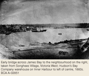
The land of James Bay peninsula was the traditional territory of the Swengwhung tribe who belonged to the Lekwungen, a linguistic sub-group of Coast Salish whose descendants are part of Songhees First Nation. In 1850 when they conveyed the peninsula, with other land, to the HBC in return for £75, they no longer lived there, but their abandoned village sites dotted the shoreline (including remains of a fortification near Holland Point) and one of their burial grounds with mortuary poles still stood at Laurel Point. The HBC had the land surveyed. The northern area bounded by Toronto, Simcoe and Montreal Streets was subdivided, mostly into town lots; the tract south and west of those streets was retained by the HBC as farmland, for grazing cattle and raising grain and root crops. In the 1840s the farm was called Ogden Fields Farm; by the early 1850s it was known as Dutnall’s Farm (after HBC farm bailiff John Dutnall); by 1855 it was called Beckley Farm, presumably after Beckley in Kent. The farmhouse and farm buildings stood near the southeast corner of Menzies and Simcoe Streets.

The Douglas & Helmcken Families
James Douglas, HBC chief factor, became the first substantial landowner in James Bay in 1851, when he bought Section VI – the block now bounded by Government, Belleville, Douglas and Superior Streets. He began construction of a fine home overlooking the waters of James Bay and his family moved in October 1852. James Bay House, demolished in 1906, stood on the present site of the Royal British Columbia Museum. In 1852 when eldest daughter Cecilia married Dr J.S. Helmcken, James Douglas gave his son-in-law an acre of land and the construction of Arbutus Lodge began. Now called Helmcken House (638 Elliot St) and operated as a museum, it is still on its original site. Indeed, it is the oldest house in the province on its original site, with the exception of Oak Bay’s Tod House.
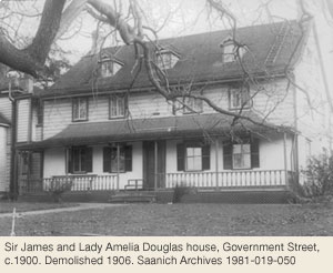
James Bay’s earliest subdivision streets were named after places in eastern North America that were familiar to the HBC officers: Superior, Huron, Michigan, Belleville, Niagara, Ontario, Kingston, Montreal, Toronto, Oswego, Erie and Quebec. A few names have been changed, such as St. John, now Pendray Street, and Ottawa and Hamilton, now part of Dallas Road. Dallas itself (named after A.G. Dallas of the HBC) now skirts only the western and southern edges of James Bay, but once was the name popularly used for the entire shoreline roadway, including what is now Belleville Street.
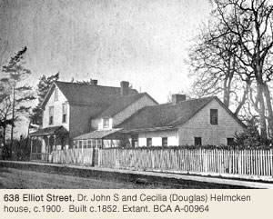
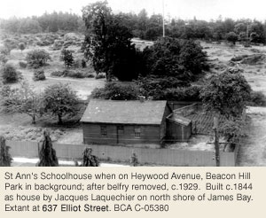
Colonial Administration Buildings the Birdcages
The major impetus for James Bay’s development as a residential suburb came in 1859 when Governor James Douglas built, across the harbour from Fort Victoria, new Colonial Administration Buildings where the Parliament Buildings are now. The series of buildings designed by H.O. Tiedemann were dubbed the Birdcages because their bell-cast roofs, half-timbering and ornate balconies gave them an exotic appearance. Moving the colonial offices to James Bay was daring because the new site was far removed from the centre of business activity in downtown Victoria. Douglas was accused of choosing the location because it was next door to his own house, thus enhancing his own property values. The bridge he had built across the bay in 1859, ostensibly to connect the Birdcages with downtown, was seen as another self-serving act. The governor denied conflict of interest, but was quick to take advantage of the situation by pushing a road through the western edge of his property from the south end of the James Bay Bridge, and creating lots along the thoroughfare, which he named Birdcage Walk. The resulting subdivision, Birdcage Terrace, became a fashionable address lined with Italianate and Gothic villas for civil servants, business and professional people. The Walk extended to the south of Douglas’s property and in the mid-1880s a matching pair of Italianate houses were built there for Hon. John Robson and his son-in-law Joseph Hunter (506 & 514 Government St).
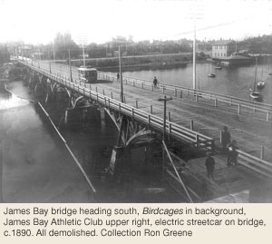
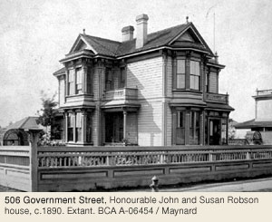
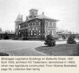
Fashionable Streets & Residences
Birdcage Walk terminated at Michigan Street and in the 1860s Michigan near Beacon Hill Park became a very fashionable enclave, with fine homes for HBC accountant Alexander Munro (where South Park School playground is now), banker A.D. Macdonald (whose brick mansion, Springfield, stood where Orchard House, a high-rise apartment block, is now) and colonial secretary W.A.G. Young (at the southeast corner of Michigan and Young Streets).
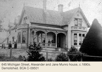
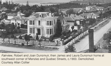
Another fashionable residential area was Menzies Street opposite the Birdcages and the south side of Belleville Street facing the harbour where a number of industrialists and sea captains chose to build. Their view of the harbour was unobstructed until about 1900, when the CPR decided to move its shipping terminal there from Wharf St. Fairview (demolished) on the corner of Menzies and Quebec Streets was best known as the home of Robert and Joan Dunsmuir before they built Craigdarroch Castle (1050 Joan Cr, Rockland). Starting in the late 1950s, Fairview and most of the houses along Belleville were replaced by motels, except on one block.
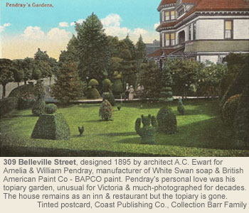
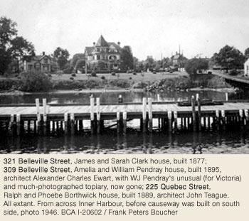
The Italianate-style houses built in 1877 for Alexander B. Gray (327 Belleville St) and James Clark (321 Belleville St) are the oldest of this early grouping still there. Two doors away, industrialist W.J. Pendray had a picturesque Queen Anne style mansion built in 1895 (309 Belleville St). It is now a restaurant and B&B. The painted ceilings, tiled fireplaces and monogrammed stained glass windows are still intact. The Pendrays’ topiary garden was a popular tourist stop and the most photographed garden in Victoria before the Butchart Gardens opened on the Saanich Peninsula.
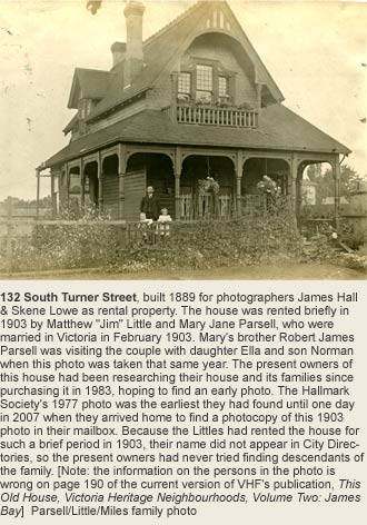
Marine Industry & Shoreline Development
In the late 19th century, prosperity was synonymous with industrial development and the James Bay waterfront was ideally suited for this. Robert Laing’s shipyard (where Fisherman’s Wharf is now) was producing steamboats by at least 1861. By the 1870s small marine ways were appearing around the waterfront below Kingston and Montreal Streets, and Jacob Sehl established his furniture factory at Laurel Point in the late 1870s. When Sehl’s factory burned, the site was purchased by William Pendray for his soap works and later Bapco paint factory. Pendray’s factory originally stood on the north shore of the James Bay mudflats, but in 1900 a long-awaited scheme saw the construction of a stone retaining wall across the mouth of the bay. The mud flats were filled in and the Empress Hotel was built on the reclaimed land. This civic beautification was encouraged by the completion of the new Parliament Buildings in 1898, designed by Francis M. Rattenbury. In 1904 Rattenbury designed a wooden marine terminal for the Canadian Pacific Railway (CPR) at the foot of Menzies and in 1923, in conjunction with Percy Leonard James, designed a grander replacement (468 Belleville St). From 1900 until the 1970s the CPR’s docks and steamers dominated the James Bay harbourfront, and though they have gone, the shoreline remains a marine transportation centre.
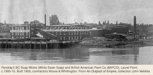
In 1872 a large tract of open land near Ogden Point was set aside for a new civic cemetery, to replace the Old Quadra Street Burying Ground. Opposition to the site by nearby landowners forced the Cemetery Trustees to buy thirteen acres at Ross Bay instead. The Cemetery Trust lands were subdivided and sold through the 1870s and early 1880s. On one portion Welch, Rithet & Company began construction of a deep-sea shipping terminal in the 1880s (now the site of the Coast Guard Station at the foot of Ontario Street) that became known as the Outer Wharf. The adjacent shoreline gradually became heavily industrialized with a flourmill, a chemical plant and warehouses. In 1891 the Dallas Hotel was built on Dallas Road at Ontario Street, designed by architect Edward McCoskrie, to cater to passengers travelling by ship to and from San Francisco and the Orient. The federal government opened an immigration building opposite the wharves (at Dallas Road and Ontario) and in 1908 built a new stone and brick structure there (demolished), which served as a detention centre for immigrants from China. Senator W.J. Macdonald purchased 28 acres at Ogden Point beside the Cemetery Trust lands and in 1876 had Thomas Trounce design Armadale, a massive stone house reputedly modelled after Armadale Castle on the Isle of Skye. Macdonald Park now occupies part of the estate.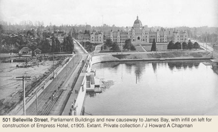
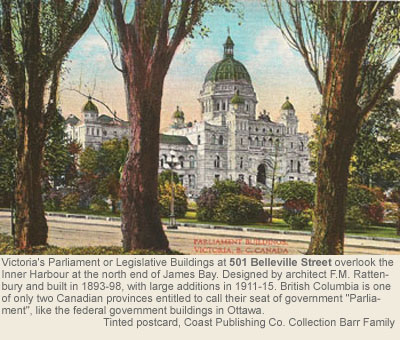
The opening of Panama Canal in August 1914 encouraged more industrial development in the vicinity of Ogden Point. A breakwater was constructed during WWI and the Ogden Point Docks were opened to deep-sea shipping. In the late 1920s a grain elevator was built and later a fish processing plant, both served by a railway barge slip. During World War II the former Outer Wharf became a major ship building facility for the Victoria Machinery Depot. The old Armadale Estate was subdivided, Pilot and Dock Streets were opened up and “Wartime houses,” affordable houses for the shipyard workers, were constructed.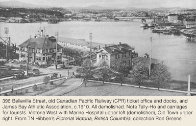
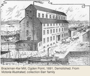
Homes for the Workers 1860s to 1890s
Starting in the 1860s trades and working class people purchased modest houses on town lots a few streets away from the harbour and generally farther away from the James Bay Bridge. Thus Quebec, Superior, Kingston and Michigan Streets west of Birdcage Walk became popular residential areas. During the 1890s many more homes for middle class and working class families were constructed. Of the dozens of houses built on these streets in the 1860s and 1870s, the James Irving House at 428 Superior Street (1873) is a notable survivor. In the 1880s and 1890s houses for longshoremen at the Outer Wharf and other workers were clustered along St. Lawrence, Ontario, Erie, Quebec, Kingston and Superior Streets. Though hundreds of houses were demolished in the 1950s and 1960s to make way for apartment blocks, enclaves of 1890s houses survive.
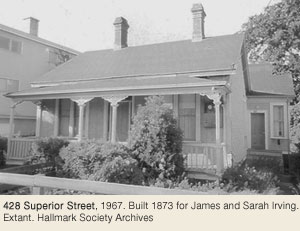
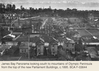
Homes for Business People & the Wealthy
For those who wanted country living in the 1860s and 1870s, James Bay had much to offer. James Bissett, an HBC employee, purchased part of Beckley Farm and in 1861 engaged Wright & Sanders to design Woodlands, an Italianate villa facing Simcoe Street (moved and renovated by Samuel Maclure in 1909, at 140 Government Street). Nearby, wholesale merchant Richard Carr had Wright & Sanders design another Italianate villa in 1863. Carr House National Historic Site at 207 Government St was the birthplace of Emily Carr in 1871. As a girl she often walked past the gun batteries erected at Victoria Point (Dallas Road at the foot of Olympia Avenue) and Finlayson Point overlooking the Strait of Juan de Fuca. Built in 1878 they were a precaution in case of a Russian invasion. When Battery Street was laid out in the late 1880s it derived its name from these defences.
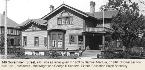
It was not until the late 1880s and 1890s that living in the southern end of James Bay, closer to the Strait of Juan de Fuca, became popular, in large part because the electric street railway ran lines to the Outer Wharf, along Menzies and Niagara Streets to Beacon Hill Park. Here large homes were interspersed with subdivisions of smaller ones. Dr. Charles Newcombe’s house (138 Dallas Rd) overlooking Ogden Point and the Macaulays’ Queen Anne mansion, Pinehurst, (originally fronting Dallas, now off 617 Battery St) are two notable surviving mansions. The east sides of Oswego, San Jose and Lewis Streets comprise almost intact streetscapes of modest houses of the late 1800s and early 1900s, but nearby streets boast many other working and middle class enclaves, notably along Niagara, Menzies, Rithet, South Turner, lower Government, Toronto, Heather, Parry, Battery and Alma Place (off Michigan) and Avalon.
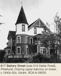
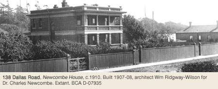
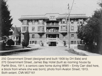
The Creation of Government Street & Development of Douglas Street
One of the last blocks to be developed was the Caledonian Grounds, a playing field bounded by Government, Niagara, St. Andrews and Simcoe Streets, owned by the St. Andrews and Caledonian Society. In 1907 the land was subdivided and the road running along the eastern side became St. Andrews Street. Before 1905 the road running along its western side was called Carr Street, but the filling in of the James Bay mudflats prompted a change. Government was extended from downtown along the new the Causeway over the reclaimed land, along Birdcage Walk, through Mrs. McConnell’s cow field and along Carr Street to Dallas Road.
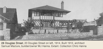
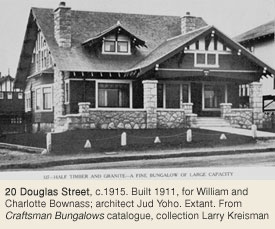
Douglas Street (originally K(C)atherine) beside Beacon Hill Park was not opened up until the 1890s, and then became the most fashionable address in James Bay. In the 1960s and 1970s many of the fine homes gave way to high rise apartment blocks, but among the remaining homes are a large Arts & Crafts bungalow for the Bownass family by Seattle architect Jud Yoho (20 Douglas St) and two examples by Samuel Maclure: the Kent House (228 Douglas Street) and the Hanna House (28 Douglas St).
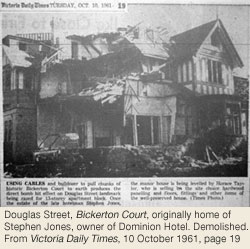
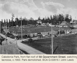
Post-World War II Redevelopment & the Rise of the Heritage Movement
James Bay, Victoria’s oldest residential neighbourhood, has also been an area of mixed use for most of its existence. It has been the neighbourhood most affected by development, with the result that few buildings from the 1850s through the 1870s survive. Many houses that stood until the 1950s were the target of post-World War II redevelopments that saw three-storey and high-rise apartments sprout up all through James Bay. A grass-roots heritage movement developed in James Bay in the early 1970s and resulted in many remaining houses being saved from the wrecker’s ball. Very much a vibrant, mixed-use neighbourhood that continues to see rapid changes, James Bay now boasts a stock of well-maintained heritage buildings and streetscapes that include some of the oldest in Victoria.
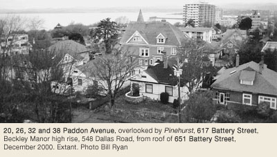
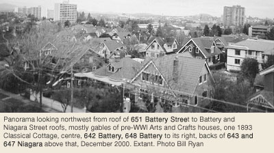
Adaptive re-use features in James Bay’s heritage conservation. Restaurants occupy two heritage houses (309 Belleville St, 225 Quebec St). Multi-unit residential conversions occupy many formerly single-family houses (617 Battery St, 24, 28, 120 & 228 Douglas St, 334 Michigan St, 138 Dallas Rd). Offices occupy others (506 & 514 Government St, 601-603 Superior St). Transient accommodation is a popular use (670 Battery St, 309, 321 & 327 Belleville St, 243 Kingston St), and several other B&Bs. A church school is now a private residence (520 Niagara St) and a church sailors’ institute is a restaurant and private residence (106 Superior St). Moving heritage buildings is discouraged, but in 2016 moving enabled five houses used as government offices once again converted to residential use (580, 584 & 588 Michigan Sts and 222 & 226 Dallas Rds).
Heritage Register Properties
178 James Bay properties on the City of Victoria's Heritage Register in 2026
Heritage-designated - Protected by bylaw. Houses eligible for VHF funding.
Heritage-registered - Not protected, may warrant future preservation. Houses ineligible for VHF funding.
Heritage covenant - Protected by legal agreement. Houses eligible for VHF funding.
NHCES - National Historic Civil Engineering Site
BCHS - British Columbia Provincial Historic Site
610 Avalon Rd
Designated 1991
613 Avalon Rd
Designated 1977
614 Avalon Rd
Designated 1979
616 Avalon Rd
Designated 1993
619 Avalon Rd
Designated 1977
623 Avalon Rd
Designated 1977
624 Avalon Rd
Designated 1977
634 Avalon Rd
Designated 1977
617 Battery St
Designated 1980
620 Battery St
Designated 1988
624 Battery St
Designated 2015
628 Battery St
Designated 1986
634 Battery St
Designated 1986
638 Battery St
Designated 1986
642 Battery St
Designated 1977
645 Battery St
Designated 1992
648 Battery St
Registered
651 Battery St
Designated 1977
652 Battery St
Designated 2010
670 Battery St
Designated 1985
674-76-78 Battery St
Designated 1979
254 Belleville St
Designated 2002
309 Belleville St
Heritage Covenant
321 Belleville St
Heritage Covenant
327-29 Belleville St
Heritage Covenant
470 Belleville St
Registered
501 Belleville St
Registered / Institutional
112 Clarence St
Registered
111-13-15 Clarence St
Registered
146 Clarence St
Designated 1978
100 Cook St / Beacon Hill Park
Designated 2010
86-88 Dallas Rd
Designated 2003
138 Dallas Rd
Designated 1977
152 Dallas Rd
Heritage Covenant
222 Dallas Rd
Designated 2016
226 Dallas Rd
Designated 2016
20 Douglas St
Registered
28 Douglas St
Registered
120 Douglas St
Designated 1985
228 Douglas St
Designated 1977
508 Douglas St
Designated 1978
606 Douglas St
Registered
680 Douglas St
BCHS
637 Elliot St
Registered
638 Elliot St
Registered
33 Government St
Designated 2007
36 Government St
Designated 1986
40 Government St
Designated 1990
54 Government St
Designated 2023
58 Government St
Registered
65 Government St
Designated 1984
128 Government St
Designated 1993
130 Government St
Designated 1986
140 Government St
Designated 1976
151 Government St
Registered
203-05 Government St
Designated 1999
207 Government St
Designated 1980
255 Government St
Designated 1976
303 Government St
Designated 1977
501 Government St
Registered / Commercial
506 Government St
Registered
507 Government St
Designated 2001
514 Government St
Registered
615-17 Government St
Registered
428 Heather St
Designated 2008
432 Heather St
Designated 2008
310 Huntington Pl
Designated 1977
314 Huntington Pl
Designated 1977
243 Kingston St
Designated 1977
301 Kingston St
Designated 1977
19 Lewis St
Registered 2024
20 Lewis St
Registered
24-26 Lewis St
Registered
35 Lewis St
Registered
38 Lewis St
Registered
39 Lewis St
Designated 2014
43 Lewis St
Designated 2014
50 Lewis St + garage
Designated 2014
53 Lewis St
Designated 2008
67 Lewis St
Registered
416 Luxton Av
Designated 2010
106 Medana St + garage
Designated 1979
110 Medana St
Designated 1989
135 Medana St
Designated 2000
162 Medana St
Designated 2000
15 Menzies St
Designated 1977
29 Menzies St
Designated 1977
60 Menzies St
Designated 2013
121 Menzies St
Designated 2021
401 Menzies St
Registered
421-31 Menzies St
Registered
331 Michigan St
Designated 1995
334 Michigan St
Registered
511 Michigan St
Designated 1979
517 Michigan St
Registered
521 Michigan St
Registered
527 Michigan St / 440 Parry St
Designated 1993
559 Michigan St
Registered
565 Michigan St
Heritage Covenant
580 Michigan St
Designated
584 Michigan St
Designated
588 Michigan St
Designated 2016
221 Montreal St
Designated 1999
225 Montreal St
Registered
520 Niagara St
Registered
570-72 Niagara St
Registered
606 Niagara St
Designated 1986
614 Niagara St
Designated 2013
615 Niagara St
Designated 2013
629 Niagara St
Designated 1995
637 Niagara St
Registered
643-45 Niagara St
Designated 1986
646 Niagara St
Designated 1986
647 Niagara St
Designated 1987
648 Niagara St
Registered
652 Niagara St
Designated 1991
Ogden Point Breakwater (187 Dallas Rd)
NHCES 2001
27 Olympia Av
Designated 2004
35 Olympia Av
Designated 1995
40 Olympia Av
Designated 1993
144 Ontario St / 242 Montreal St
Designated 2004
147 Ontario St
Registered
213 Ontario St
Designated 1996
51 Oswego St
Registered
55 Oswego St
Designated 1986
59-61 Oswego St
Registered
65 Oswego St
Designated 2004
101 Oswego St
Designated 1977
117 Oswego St
Designated 1992
119 Oswego St
Designated 2000
151 Oswego St
Designated 1977
247 Oswego St
Designated 1977
20 Paddon St
Registered
23 Paddon St
Designated 2001
26 Paddon St
Registered
32 Paddon St
Registered
38 Paddon St
Registered
427 Parry Street
Designated 1981
221 Quebec St
Designated 1977
225 Quebec St
Designated 1977
145 Rendall St
Designated 2022
149 Rendall St
Designated 1991
155 Rendall St
Designated 1977
160 Rendall St / 351 Simcoe St
Designated 1985
109 St Andrews St
Designated 2001
134 St Andrews St
Designated 2002
218-20 St Andrews St
Designated 2010
231 St Andrews St
Designated 1989
330 St Lawrence St
Designated 2011
426 St Lawrence St
Designated 2011
35 San Jose Av
Designated 2018
40 San Jose Av
Designated 1989
309 Simcoe St
Designated 1980
333 Simcoe St
Designated 1996
403 Simcoe St
Designated 1993
512 Simcoe St
Registered
642-646 Simcoe St
Registered / BCHS
15 South Turner St
Designated 1992
41-43 South Turner St
Designated 2003
102 South Turner St
Designated 1979
106 South Turner St
Registered
116 South Turner St
Designated 1985
117-19 South Turner St
Designated 1989
122 South Turner St
Designated 1985
126 South Turner St
Designated 1990
131-33 South Turner St
Designated 1979
132 South Turner St
Designated 1985
154 South Turner St + carriage house
Designated 1999
161 South Turner St
Designated 1987
106 Superior St
Designated 2005
224 Superior St
Designated 1986
428 Superior St
Registered
563 Superior St
Registered
601-03 Superior St
Resgistered
649 Superior St
Registered
526 Toronto St
Designated 1993
588 Toronto St
Designated 1992
589 Toronto St
Designated 1980
601 Toronto St
Registered
603 Toronto St
Registered
609 Toronto St
Designated 1999
Gonzales
By Carey Pallister with Ken Roueche © 2004
This neighbourhood is named for Spanish explorer Gonzalo Lopez de Haro, first mate of the Spanish ship Princesa Real, who helped chart the waters around Vancouver Island in 1790. He also lent his name to Haro Strait and Haro Rd on Ten Mile Point. Joseph Despard Pemberton, the first colonial land surveyor, named his home Gonzales. The home stood at St. Charles and Rockland for almost 100 years before being demolished in 1952. And Gonzales Rd, created in the 1920s, derived its name from the house.
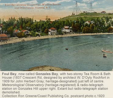
Today, the Gonzales neighbourhood is an area bounded by Gonzales (Foul) Bay to the south and Oak Bay Avenue to the north. The western boundary runs north on St. Charles St from Dallas Rd to Richardson St then east on Richardson to Richmond Av and north on Richmond to Oak Bay Av. The eastern boundary takes a more direct route along the border with Oak Bay with a small jog around the old observatory. These modern political boundaries, however, do not reflect the historical division or land use of the area.
South Gonzales: BC’s First Female landowner Isabella Ross
In 1855, Isabella Ross became the first female landowner in the colony when she purchased 99 acres from the Hudson’s Bay Company which had bought the land from the Chilcowich Tribe. The land included most of what is now Ross Bay Cemetery, Hollywood Park, the Chinese Cemetery and the western part of Gonzales Hill (known historically as Section 19). Part of these lands form the southerly section of the Gonzales neighbourhood as far north as Lillian Street.
Isabella Ross and her children lived on her property at “Fowl Bay Farm" (possibly shown in photo above). Isabella’s husband Charles Ross had been a Hudson’s Bay Company Chief Trader in charge Fort Victoria and had died in 1844 soon after the fort was completed. Mrs. Ross began to subdivide her land as early as 1859 in order to support her family. The new owners were primarily interested in the land for investment and generally did not build; instead they held onto the land, in the hope that it would increase in value.
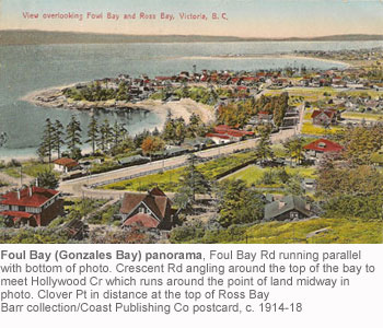
The sheltered waters and pleasant beach of Foul or Gonzales Bay provided a lovely spot for swimmers and picnickers and by the beginning of the 20th Century it had become a popular location for summer homes. Eventually showers and a dance pavilion were built for the holidaymakers. In 1903 the Chinese Consolidated Benevolent Association purchased land at Harling Point, on the east side of Foul Bay, for a cemetery. Many predicted that this would have a negative impact on real estate value in the area, but this proved to be largely untrue.
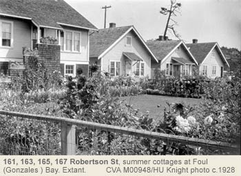
Through the 1950s and 1960s, Gonzales beach remained a popular recreation area, but the small beach cottages and cabins began to fall victim to the wrecker’s ball and larger more permanent houses were built in their place. The beach was not without its problems; noisy beach parties and difficulties with log jams and beach fires were a constant source of frustration for local residents. For three days in November 1969, the worst storm in memory battered the Victoria shoreline. Due to the efforts of the beach residents, no homes were lost, but in order to prevent further erosion or loss of property, the City built a retaining wall around most of the bay the following summer, giving the bay a new look.
Central Gonzales: J.D. Pemberton and the Merchant Class
Joseph Despard Pemberton owned the remainder of the land that now comprises the Gonzales neighbourhood stretching from Lillian Rd north to Oak Bay Av (known officially as section 68 and part of section 74). Like Mrs. Ross, J.D. Pemberton also began to sell off parcels of his land early on. Members of the wealthy merchant class such as A.C. Flumerfelt (855 Pemberton Rd, Rockland), Thomas Earle, the McQuades, A.J. Woodward, Angus R. Johnston, John Chandler, William Bayliss and Thomas Shotbolt purchased property in the area. Thomas Shotbolt, a pharmacist, built a grand home, Hollywood, in 1890 on seven acres; the house, at the SE corner of Foul Bay and Fairfield Rds, was a landmark in the neighbourhood until it was demolished in 1947.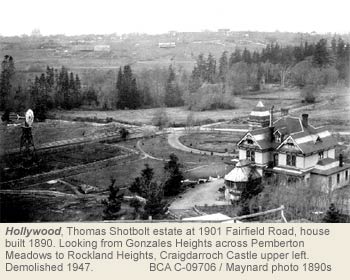
Pemberton did retain large tracts of land for himself, which he used for grazing pastures. The Pemberton property stretched from Rockland Av to Chandler St and from St. Charles to Gonzales. This area became known as Pemberton Meadows and a wooded area, Pemberton Woods.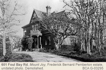
Development of the Streetcar Suburb
It was not really until after the turn of the century that the improved infrastructure and the economic and housing booms, which began in 1908, turned this area into a popular residential neighbourhood. On March 21, 1909 the No. 6 Streetcar began service to Fairfield and Gonzales.
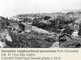
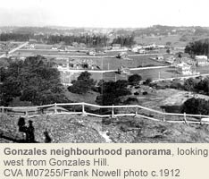
The two mile extension of street car service ran down Cook St, across May St to Memorial Cr and up to Fairfield Rd, terminating at a loop at what is now the Margaret Jenkins School playing field.
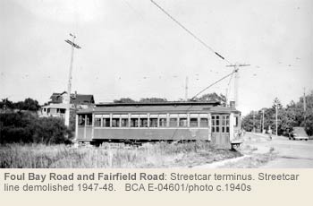
Streetcars were the backbone of the local transportation systems until the major expansion of bus service after WWII. The No.6 Line was carrying 5100 passengers per week in 1945, second only to the Esquimalt Line. However by July 1946 the company had signaled its intent to close the No.6 Line beyond Joseph St in Fairfield, and replace it with bus service. City Council resisted. So, when the Fairfield-Gonzales bus commenced service on November 28, 1946, the No.6 streetcar also continued to run to its distant grassy loop at Foul Bay Rd. No.6 ceased operations completely on December 1, 1947.
The Grand Houses of Foul Bay
After Major Guy and Mrs. “Byrdie” (Dunsmuir) Audain moved into a Maclure-designed home at 550 Foul Bay Rd in 1909, the street became a fashionable place to live. The wealthy hired architects such as C. Elwood Watkins, Elmer E. Green, Henry S. Griffith, William D’Oyly Rochfort and Samuel Maclure to design elegant Arts & Crafts homes, many of which survive today and have been recognized for their heritage significance.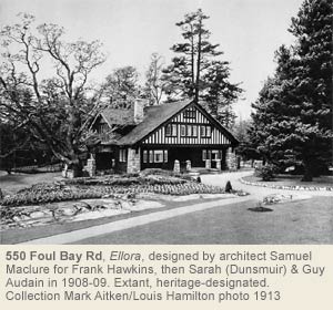
The most famous Gonzales area residents, however, were a couple who are not famous because of who they were, but because of the legacy they left – their garden. The Abkhazi Garden (1964 Fairfield Rd) was the work of Margaret “Peggy” and Nicolas Abkhazi who bought the property on Fairfield Rd in 1946. In 1999 the garden received international attention when residents of Victoria fought to save it from development. Slightly more than one acre, the garden features native Garry oaks, ornamental evergreens, rare rhododendrons and azaleas, rock and alpine plants, Japanese maples and weeping conifers.
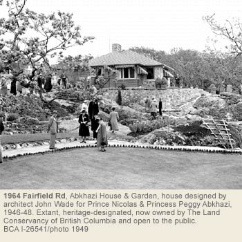
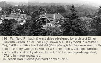
Market Gardens and Greenhouses
The area was not always exclusively residential. The fairly level topography and good soil made the area ideal for greenhouses. They were a major part of the early days of development with the largest operation located on Fairfield Rd at the current site of Glengarry Hospital. Immediately to the west was a Chinese business, Fairview Greenhouses, at 1650 Earle St, just east of the entrance to Hollywood Park. The third was considerably smaller and was located at the northwest corner of Lillian and Richmond. The greenhouses were built in the 1920s and survived until the end of the 1950s when they finally surrendered to the post-war housing boom.
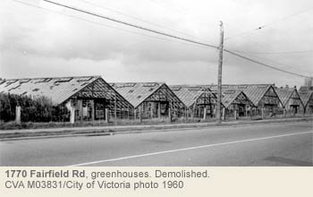
Gonzales Observatory
In 1914 the Pacific Coast headquarters for the Dominion Meteorological Services, commonly known as the Gonzales Observatory (302 Denison Rd), was built on top of Gonzales Hill to the designs of William Henderson, Dominion Government Architect for BC, with meteorologist Francis Napier Denison. It recorded weather and took astromical and seismic readings. It was also from there that the time ball, which was located on the top of the Belmont Building (Humboldt and Government Sts), was activated every day at noon by Denison, the superintendent of the station. Environment Canada abandoned the building in 1989 and after several failed proposals, the site was finally purchased by the CRD in 1992 and the 1.75 hectares of land turned into a wilderness park.
The Dominion Government Wireless Station (see photo in opening paragraph) was nearby and served as a communication centre from before World War I until just after World War II. That building has since been demolished.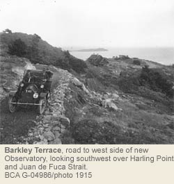
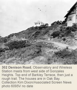
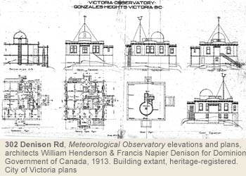
Schools and Local Businesses
As the population in the area increased so did the need for schools, local stores and other services. Margaret Jenkins School at 1824 Fairfield Rd opened on August 23, 1915. Built on a two-acre parcel of land that had been part of the Chandler Estate, the school was designed by architects Spurgin & Wilkins; a two-room school had been opened on the site in 1913. Margaret Jenkins School is the only school in the district to be named after a woman. A few streets north, the Norfolk House School for Girls, a private school which had moved locations many times, commissioned architect Percy Leonard James to design a school on a five-acre site at Richmond and Gonzales (801 Bank St) in 1931. It is interesting to note that the school used the old Pemberton home, Gonzales, as the residence for the boarders until 1952. In 1986, the school merged with Glenlyon Preparatory School for boys to form Glenlyon-Norfolk School.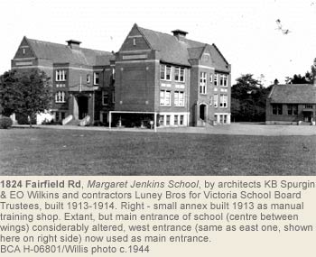
In 1912, William Bayliss, a hotel owner and butcher, opened Hollywood Grocery & Meats at the corner of Fairfield and Lillian. By 1927 the corner included a post office and the Victoria School of Expression. Retail activity continued to expand and by 1952 this corner included a barbershop, shoe repair shop, dry goods store and a beauty salon. Another group of small shops opened up at the corner of Fairfield Rd and Foul Bay Rd, opposite Margaret Jenkins School.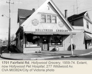
Street Names
The street name in the neighbourhood that has received the most attention over the years is Foul Bay Rd. It all started in 1924, when Ald E.S. Woodward gave notice of motion to Victoria City Council to change the name of the Bay from Foul Bay to Gonzales Bay and Foul Bay Rd to Gonzales Bay Rd. 183 property owners, including some well-known citizens, signed a petition that forced the Council to take the matter seriously. One resident summed up the feelings of the residents “[the name] offends good tastes and in its ordinary meaning conveys a very wrong impression of the beautiful sand-fringed and clear bathing beach.” A heated debate raged in the newspapers and research was undertaken to find the origin of the name. Francis H. Ross (1401 May St, Fairfield), grandson of Isabella, was determined that the name should stay but his arguments were not heeded and the name of the Bay was officially changed to Gonzales Bay in 1934. However, the feature is still called Foul Bay by many Victoria residents.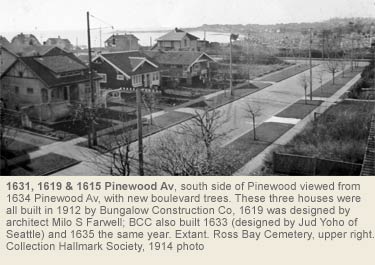
Other Gonzales streets are named for early landowners such as Chandler St for John Chandler (512 Simcoe St, James Bay), a Hudson’s Bay Company factor; Earle St for Thomas Earle, a prominent merchant and politician who served on City council and as a Member of Parliament; and Robertson St which is probably named for Robert Affleck Robertson who appears as early as 1872 on Gonzales area land registry documents. Thomas Shotbolt, the well-known pharmacist, gave his name to Shotbolt Rd and Hollywood Cr was named for his fabulous home.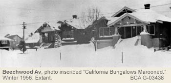
Irving and Beaven Sts (previously Cross Rd) were named in honour of well-known Victorians. Paulus Aemilius Irving came to BC in 1882, served as Deputy Attorney General from 1883 to 1890 and was appointed Judge of the Supreme Court in 1897. Robert Beaven came to BC in 1862. He was a merchant and became involved in provincial politics. He served as BC premier from 1882-1883 and as mayor of Victoria from 1892-1893.
In the northern section of the neighbourhood, Clare St was probably named for the Poor Clares, an order of Catholic nuns who arrived here October 19, 1911 and established a monastery at 2050 Haultain St. Well-known Victorians are remembered in Redfern St and Davie St. Charles E. Redfern was a jeweller and watchmaker who served as mayor in 1883 and from 1897 to 1899. Dr. John Chapman Davie (638 Rockland Pl, Rockland) was a medical doctor and a Member of Parliament. Amphion St is named for HMS Amphion, which was a Leander class cruiser assigned to this coast in 1888. In 1889 she ran aground and sustained serious damage but was repaired and continued to serve the Royal Navy until she was sold in 1904. Somenos, Quamichan and Cowichan honour some of Vancouver Island’s local First Nations.
From 1909 until 1945 development progressed slowly, initially supported by the extension of streetcar service and then by the 1907-1913 real estate boom. Following the 2nd World War, another housing boom saw the remaining vacant land developed. The Gonzales neighbourhood has evolved from farmland to one of Victoria’s most popular neighbourhoods in less than 150 years.
Heritage Register Properties
36 Gonzales properties on the City of Victoria's Heritage Register in 2026
Heritage-designated - Protected by City bylaw. Houses eligible for VHF funding.
Heritage-registered - Not protected, may warrant future preservation. Houses ineligible for VHF funding.
Heritage covenant - Protected by legal agreement. Houses eligible for VHF funding
1007 Amphion St
Registered
1052 Amphion St
Designated 1988
971 Bank St +interiors
Designated 2003
160 Beechwood Av
Designated 1993
271 Beechwood Av
Designated 2012
423 Chadwick Pl
Registered
1038 Chamberlain St
Registered
1837 Crescent Rd
Registered
1058 Davie St
Designated 1998
1063 Davie St
Registered
1077 Davie St
Registered
302 Denison Rd
Registered / Institutional
1689 Earle St +interiors
Designated 2007
1693 Earle St
Designated 1997
1961 Fairfield Pl
Designated 1999
1824 Fairfield Rd
Registered / Institutional (2 buildings)
349 Foul Bay Rd
Registered
515 Foul Bay Rd
Designated
550 Foul Bay Rd + wall
Designated 1994
610 Foul Bay Rd
Registered
611 Foul Bay Rd
Designated 2000
630 Foul Bay Rd
Registered
902 Foul Bay Rd – stone wall & gate only
Designated 2003
934A Foul Bay Rd
Designated 1986
1844 Hollywood Cr +wall
Designated 1998
954 Maddison St +interiors
Designated 2012
1614 Pinewood Av +garage, interiors
Designated 2002
1009 Richmond Av
Registered
131 Robertson St
Designated 1998
162 Robertson St
Designated 2008
304 Robertson St +garage
Designated 1996
1952 Runnymede Av
Designated 2014
213 St Charles St
Designated 2013
117 Wildwood St
Designated 1992
121 Wildwood St
Designated 2002
Fairfield
By Cornelia Lange, with Richard Linzey & Helen Edwards © 2004
Many prominent Victoria landmarks border Fairfield. To the south is the waterfront and Strait of Juan de Fuca, with views of the Olympic Mountain range. To the north on Richardson, Government House grows out of a rocky outcrop bisected by Linden to Fort St. The west includes the Cathedral Hill precinct, Humboldt Valley, and Beacon Hill Park, while the east includes Ross Bay Cemetery
Long before the first Europeans arrived, First Nations people had hunted, fished and harvested the area, with seasonal camps in protected harbours and defensive positions on the cliffs and hilltops. The marshes were rich in fish and wildfowl, and sometimes, to avoid winter storms round the James Bay peninsula, they took a Ross Bay stream as a shortcut, with a portage from the wetlands to meet another stream flowing into the Inner Harbour.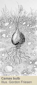
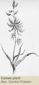
These indigenous people, Lekwungen, had a sacred place on the grassy knoll, Mee-qan, sometimes translated as “warmed by the sun,” and now known as Beacon Hill. They used the hill and meadows to nurture and harvest the starchy camas bulbs, and roasted them for food. This was also an important burying ground, and in 1857, archaeologist James Dean counted 23 native burial cairns covering the hillside, though many of these have since disappeared, as the stone was looted for construction. Cliffs to the south show evidence of native use, including a fortified village at Finlayson Point.
The First Settlers & Subdivision
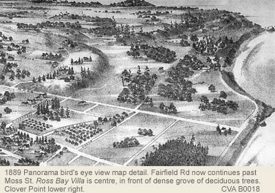
In 1842 James Douglas, making his second visit to the area in search of a site for a trading-post for the Hudson’s Bay Co (HBC) landed at Clover Point, named after the red clover growing there. The fort he founded on the Inner Harbour and its network of farms grew rapidly, spilling into the nearest convenient building spaces. For Fairfield, development came comparatively late, as it was remote from Downtown and predominantly marshland. Land divisions for Fort Victoria were developed on the Wakefield Plan, which allowed the HBC to sell minerals and timber, but 90 percent of the proceeds had to be spent on farms, roads, education, a local militia, fortifications, and park and church reserves.
Religious Institutions & Schools
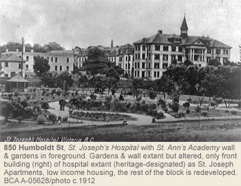
The Anglican Archdiocese acquired two city blocks from Blanshard to Vancouver atop Church Hill, the site of three successive cathedrals (908-12 Vancouver St), while Roman Catholic land lay below in the Humboldt Valley. Father Michaud of the Clercs de St. Viateur came to Victoria with the first four Sisters from Quebec in 1858. He designed and built St. Andrew’s Cathedral in the style favoured for rural Quebec churches. In 1871, St. Ann’s Academy was built as a school and residence, and the “cathedral” was skidded into place as the academy chapel (835 Humboldt St). The Sisters of St. Ann started St. Joseph’s Hospital in 1875 (850 Humboldt St), which expanded over the years to include a school of nursing, nurses’ residence, and Mount St. Mary residence for seniors (999 Burdett Av)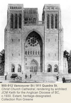
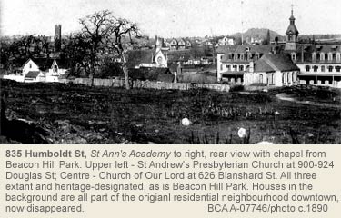
Fairfield Estate … and Grand Houses
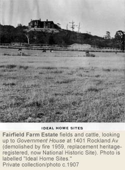
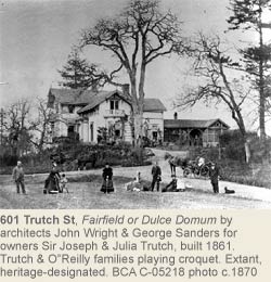
The original Fairfield Estate lay east of the Church Reserves and was given to the Governors of the new colony, but the first, Sir Richard Blanchard, returned to England after just a short stay. Sir James Douglas then became Governor and the owner of Fairfield Estate in 1858. Following a change in British colonial policy that mandated the establishment of a Crown Colony with an elected legislature (land ownership was necessary for voting privileges), the HBC began to sell portions of its land, mostly to HBC officials. Douglas also leased large tracts of his land to tenants who wished to farm: largely market gardens and dairy farms. Fine houses quickly followed. In 1859, civil engineer Joseph Trutch arrived in Fort Victoria and by 1861 had a home designed by Victoria’s first major architects, John Wright & George Sanders, on a 10-acre piece of Fairfield Estate (601 Trutch St). In 1862 Trutch was elected to the Vancouver Island Legislative Assembly and in 1871 became the first Lieutenant-Governor of the new province of British Columbia.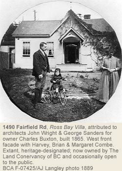
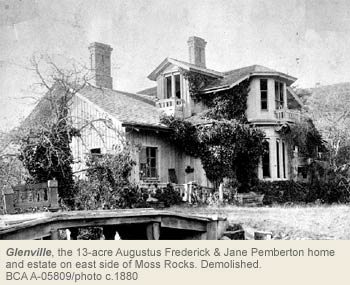
In 1865 Wright & Sanders likely also designed a home at 1490 Fairfield Rd for Charles Buxton. It was advertised as a “suburban residence” and leased to Francis Roscoe, a prosperous hardware merchant who became the Liberal MP for Victoria in Ottawa 1874-78. After his death, the new owners called the home Ross Bay Villa, as it is still known today. Through the extraordinary efforts of the city’s heritage planner, local heritage advocates, and the newly organized The Land Conservancy, this home was saved and designated a Heritage Site in 1999.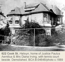
Victoria’s huge growth and prosperity in the late 19th Century was reflected by many other fine homes built in Fairfield. The Hon. A.F. Pemberton, Victoria’s first police court magistrate and cousin to J.D. Pemberton, had Glenville built at the corner of Fairfield and Moss in the 1880s. It stood where Fairfield United Church stands today, and included a rock garden and tennis courts. In 1876, architect John Teague designed a handsome dwelling for Sir Matthew Baillie Begbie (knighted in 1875 and nicknamed the “hanging judge”) on Collinson and Labouchere, now Fairfield, west of Cook St, with bay windows, niches in the main room for statues, ornamental cornices, wine cellar, stables, and outbuildings (all demolished). At the corner of Fairfield and Moss was Alfred J. Langley’s home, The Maples. He operated Langley & Co Druggists on Yates St.
After Sir James Douglas’s death, his estate was administered by trustees until 1900-01, when his two grandsons came of age, their father having died suddenly and unexpectedly. John Douglas built his Arbutus House (demolished) on the east side of a high point of volcanic rock scoured from the glacial retreat in the ice age, now known as Moss Rocks. His brother, James Andrew Douglas, built a handsome home on the west side of the same hill named Lillooet: It was demolished by developers in 2009.
To the north, Fort St quickly grew with shops and large homes spreading to the Rockland hilltop, while Cook St skirted the hill. Halwyn (demolished) was home to Hon. Justice Irving, c.1902, with its circular driveway entering and exiting Cook near Richardson. The Hon. Capt. Robert Tatlow, BC Government Finance and Agricultural Minister from 1903-1910, had a 2½-storey shingled house, Maple Croft (demolished). With steeply gabled roof, sleeping porches, and a wraparound verandah, it stood at the corner of Cook and McClure. Horse stables and hitching posts used by these residents have long since disappeared except in rare cases (Oliphant, Rockland).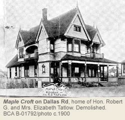
Modest Homes & Apartments
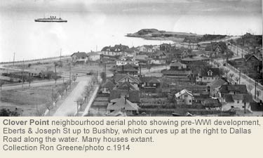
The inclusion of Fairfield within the City's boundaries of the city in 1890 and the construction of Fairfield Rd to connect it to the downtown core encouraged residential living. As the marshes were drained and streams culverted [C.C.Pemberton, who grew up in Glenville on Moss Rocks, recalled watching fires burning in the peat bogs below Government House, in the area that is now Thurlow & Brooke Sts. (BCA MS-0522. Reference courtesy John Adams.) A streetcar route was planned. The old Smith Dairy farm had operated south of Faithful St on land owned by James Andrew Douglas since 1860, but by 1907, the BC Land & Investment Co had sold it to a Calgary millionaire who built roads and created 171 lots. Many humble homes, some with only two rooms, were built, in contrast to Frederick Futcher’s two-lot home at 55 Marlborough, complete with servant quarters, or Christina Haas’ three-bedroom, three-bath, upscale bordello on two lots at 59 Cook St.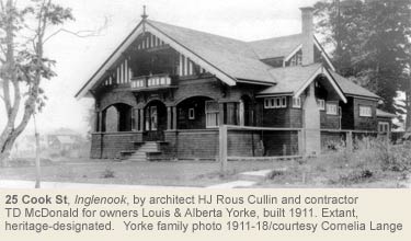
During the great land boom that followed from 1907-13, Fairfield quickly developed into an Edwardian, middle-class neighbourhood. Ads for homes featured “mature fruit trees” and rich dark soil for kitchen gardens. Local merchants lived amongst their customers and community assets sprouted: The Beacon Hill Park Lawn Bowling Club; Sir James Douglas Elementary School (1910, 401 Moss St); various churches like Fairfield United Church at Fairfield & Moss (1926), services like Mount St. Mary’s Hospital (1941), the New Horizons Seniors' Activity Centre (1975); Fairfield Community Association (1975), the Boy’s Club Hall on Chester St; and activities such as the Moss St Market (1991).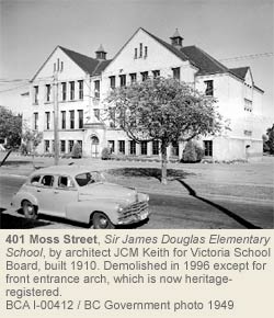
The residential building boom ended in 1913-14, and the neighbourhood took many years to infill with more modest homes. But automobiles brought with them wider roadways, garages, and gas stations, which became a neighbourhood feature. One early commercial garage still exists today at the corner of Vancouver & Collinson St. The first gas stations, at Cook and Pendergast, and Moss and Fairfield, are no longer there. By 1918 Dallas Rd was being promoted as a scenic marine drive.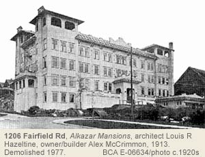
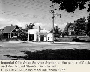
After 1900, apartments with posh lobbies, maid's quarters, and fireplaces were copied from New York and Paris: October Mansions (1910. 1030 Cook at Fort), Mount Edwards Apartments (1911, 1002 Vancouver St), Hampton Court (1913, 159 Cook St), Tweedsmuir Mansions, a 1936 Art Deco apartment at 900 Park Blvd and Art Moderne-style apartments north of Beacon Hill Park are notable examples. The Glengarry of 1908, a more affordable apartment in the Cook Street Village, was demolished in 2004 to make way for more expensive, modern, and dense condo living. Spurred on by a federal program to promote rental accommodations, 1970s developers demolished many older homes to make way for apartment buildings. Community members recognized the loss of beautiful stately homes, making the Cook St corridor unrecognisable. On Heywood Av, almost an entire block of homes was razed, only one small home surviving. A flashpoint for the community came when seniors were evicted from Alkazar Mansions, 1206 Fairfield Rd and Linden Av to permit demolition in 1977.
The Park, and Early Social Life
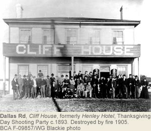
Beacon Hill Park was set aside as a public park in 1858. A beacon on its highest point warned mariners of the submerged reef called Brotchie Ledge, close to the entrance to Victoria Harbour. Horse races were held from 1858 to 1894 around the hill until they moved in 1889 to the Willows Grounds in Oak Bay. When Henry Henley leased 15 acres east of the park in 1860 for his Henley Hotel overlooking Clover Point, he encouraged his daughter to participate in horse racing around Beacon Hill, which raised Victorian eyebrows as the girl had to wear men’s silk jockey clothing to race. After Henley’s death in 1892, his son changed the name to Cliff House; it then burnt to the ground in 1905.![]()
In 1882 city council organized a loan of $25,000 for Beacon Hill Park landscape development, resulting in the lake area and a small Victorian-style zoo. For years, some people complained about the condition of the bear pits. John Blair designed the landscape in 1889, with much of the park left in its natural state. The east side of Beacon Hill Park borders Fairfield, where the cricket field is located.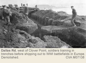
Many early Fairfield citizens were part of a local militia. Volunteer rifle companies and artillery batteries were formed as protection against external threat. Units trained and conducted exercises at an artillery battery on Finlayson Point built in response to the threat of Russian invasion in 1879, at a rifle range at Clover Point, and in mock battles in Beacon Hill Park. Schools had cadet corps until after WWII. During WWI, trenches dug at the cliff tops of Dallas & Marlborough were used for troop training. The rifle range lasted until 1923, when neighbours’ complaints about danger and noise were finally heeded.
The Cemeteries
Prior to the Ross Bay Cemetery, graves were primarily located beside Christ Church Cathedral on Quadra St, now known as Pioneer Square (1030 Quadra St), and in the Jewish Cemetery. Robert Burnaby bought some of Isabella Ross’s land (see Gonzales History), and sold 12 acres in 1872 to the Cemetery Trustees. Today the old curved farm road to the Ross home is incorporated into the cemetery design.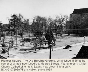
During the 1930s, the City of Victoria began planting trees that are now mature and form a green canopy over the gravesites. The Victorian-style cemetery contains numerous mausoleums and tall pillars from the early elite; several BC premiers are buried here. The road on the west of the cemetery was renamed from Lover’s Lane to Memorial Cr early in WWII to commemorate fallen soldiers. In 1977, vehicle traffic through the cemetery was closed but vandalism of historic grave markers remains a serious concern. In 1997, the city designated the cemetery a Heritage Site.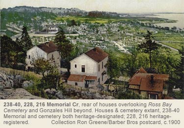
From 1880 to 1892, a dwelling on the western side of the cemetery served as an exclusive private boys’ school. The city purchased the land from the Trustees of the Douglas Estate, converting the building to The Home for Aged and Infirm Men, administered by the city of Victoria. In 1894 and 1906, the city purchased more land to expand the cemetery on the east side. A 1909 storm washed away graves located on the beachfront and in 1912-13 a seawall was built to protect the cemetery; Dallas Rd was extended along the cemetery’s south border. In 2000, the city dumped tons of gravel just off the beach, stabilizing the waterfront against ferocious winter surfs.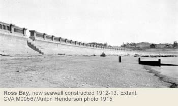
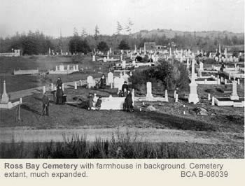
Infrastructure & Businesses
In 1878 the city boundary stopped at the corner of Pakington and Cook St. Further south, dairies run by Henry Smith, Joseph King, Robert Knowles, and Mrs. Irving dotted marshland bisected by seasonal streams. In 1892, city council approached the Trustees of the Douglas Estate to lease Section 82 of Fairfield Farm Estate for a garbage dump next to Clover Point. The trustees refused, but did allow brick tunnels down Moss St to create the Clover Point sewer outfall. Emily Carr in her Book of Small recalls Cook and Pakington being used as a garbage dump, which it was until after 1907 when Cook St was extended to the waterfront. To reduce open dump sites in the city, in 1908 the city began using scows to dump garbage in the ocean just past Brotchie Ledge. Much of the garbage floated back to the beach, collecting at Clover Point and Ross Bay. Efforts to clean up Clover Point began in the 1930s and in 1958 garbage was redirected as landfill to Mud Bay.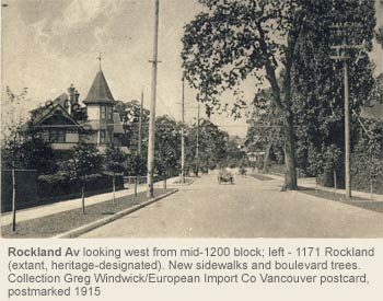
Early in the century, the city began expanding other infrastructure, building roads, sidewalks, boulevards, curbs, gutters, water lines, and sewer connections, plus planting street trees. Over time, streams running through Fairfield were covered and routed into the storm drains.
Streetcar service was established in 1909 down Cook St, turning left on May St to Fairfield Rd and turning round at Foul Bay Rd. People hopped off the trolley on their way home to shop along the route. Corner stores popped up at Cook and Meares (Wong Bros. Grocer - the oldest still surviving in Fairfield), Cook and Fairfield, Fairfield and Vancouver, Cook between Oscar and Oliphant, May and Linden, May and Moss, Moss and Fairfield, Memorial and Fairfield. Early subdivision residents could get dairy products, ice, firewood, produce, and newspapers delivered daily to their homes. The streetcar line was finally torn up in 1947-48 in favour of buses.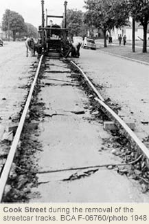
In 1957 a Provincial Capital City beautification grant was used to build the looped roadway on Clover Point, parking for 100 cars, a path to Cook St, and a boat ramp. Soil was levelled, bullets removed, and power lines buried. The City of Victoria’s 100th anniversary celebration at Clover Point included a bonfire and fireworks on August 2, 1962. In 1977 a pumping station was built underground. In 1991 a new outfall pipe moved waste water 4,500 ft into the Juan de Fuca Strait, away from shore.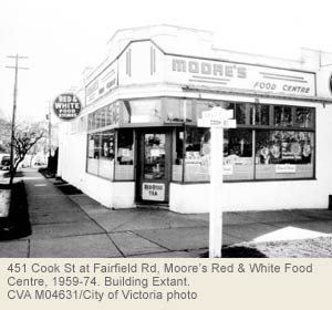
Houses, Gardens & Community
Herbert Warren, raised in South Fairfield, went to agricultural college in Guelph, ON, and then was Victoria's Park Superintendent from 1931-1970. Warren hybridized Japanese cherry trees that could thrive in Victoria’s climate. He raised his own family at 28 Marlborough St, close to his office in the Beacon Hill Park Nursery (built 1905).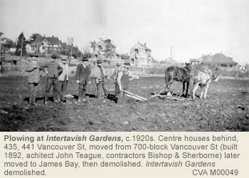
A former mayor of Salisbury, England, Thomas Futcher lived at 1029 Pakington St and imported Asian goods including chrysanthemums and flowering maples. Several commercial nurseries developed in the area. Dr. John S. Helmcken proposed that the city acquire the Invertavish Gardens as an extension of Beacon Hill Park in 1896 but the city declined. The last of the greenhouses was demolished in 1952 and the area has redeveloped with no trace of the beautiful grounds. Horticultural exemplars in the area include J.T. Higgins, who in 1886 advertised his Florist and Ornamental Garden shop at Vancouver & Fairfield and himself as gardener to Sir M.B. Begbie. Richard Layritz had a nursery running along Moss and Richardson Sts. The Woodward family originally lived behind their greenhouses at Fairfield and St. Charles. They were replaced in 1958 by Fairfield Plaza.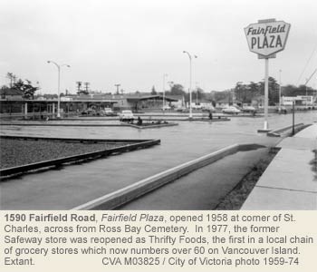
Now, roads are generally wide with boulevards and street trees - notably horse chestnuts on Cook St (1893) and flowering cherries, plums and May trees. Today’s Fairfield exemplifies the development of ‘suburban’ Victoria and the creation of aspects of a classic British colony. It also reflects trade patterns in its American west coast architectural styles in its key period of development. Italianate, Victorian, and Edwardian homes were the first to be constructed, while California and Craftsman bungalows followed. Post war, infill homes and Art Moderne-style apartments were followed by Ranch-style homes.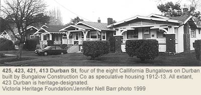
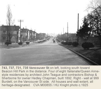
The Fairfield Community Association (FCA) came into being in 1975. Members were elected to council and city committees, which in turn generated new zonings and bylaws incorporated into a local plan. Guidelines for future neighbourhood development and specifically the Cook Street Village were developed with community consultation. The FCA played a major role in the City’s first round of heritage designations in the 1970s and has continued to support the heritage program’s objectives. While many historical buildings have succumbed to redevelopment over the years, the people in Fairfield are still connected to the land, the sea, the built environment, and their community.
Heritage Register Properties
137 Fairfield properties on the City's Heritage Register in 2026
Heritage-designated - Protected by bylaw. Houses eligible for VHF funding.
Heritage-registered - Not protected, may warrant future protection. Houses ineligible for VHF funding.
Heritage covenant - Protected by legal agreement. Houses eligible for VHF funding.
NHS - National Historic Site.
335 Arnold Av
Designated 2001
417 Arnold Av
Designated 2008
426 Arnold Av
Designated 2008
427 Arnold Av
Designated 2008
805 Broughton St
Designated / Commercial
821-23-25 Broughton St
Designated 2009 / Commercial
911-13-17 Burdett Av
Designated 1977
923 Burdett Av
Designated
999 Burdett Av – wall
Designated wall, 2005
1060 Burdett Av
Designated 1997
1139 Burdett Av
Designated 1989
1143-45 Burdett Av
Designated 2001
123 Cambridge St
Registered
1328 Carnsew St
Registered
1244 Chapman St
Designated 1991
308 Chester St
Registered
354 Chester St
Registered
1440 Clifford St
Designated 2006
1456 Clifford St
Registered
907 Collinson St
Designated 2003
911 Collinson St
Designated 1993
938 Collinson St
Designated 2003
1 Cook St
Designated 1987
15 Cook St
Registered
25 Cook St
Designated 2003
59 Cook St
Designated 2016
75 Cook St
Designated 2008
97 Cook St
Designated 2014
139 Cook St
Registered
159 Cook St
Designated
1005 Cook St
Designated 1977
1009 Cook St
Designated 1977
1134 Dallas Rd
Registered
423 Durban St
Designated 2005
451 Durban St
Designated 1998
141 Eberts St
Registered
906 Fairfield Rd
Designated 2009
962-64 Fairfield Rd
Designated 1994
1004 Fairfield Rd
Designated 2000
1036 Fairfield Rd
Registered
1490 Fairfield Rd
Designated 2000
1495 Fairfield Rd
Designated
1120 Faithful St
Designated 2018
1271 Faithful St + garage + interiors
Designated 1998
819-823 Fort St
Designated 2019
825 Fort St
Designated / Commercial
1125 Fort St
Designated 2021
1127 Fort St
Registered
1133 Fort St
Designated 1977
1141 Fort St
Designated 1976
1161 Fort St
Designated 1977
1311 Franklin Tce + garage
Designated 2001
936 Heywood Av
Designated 2006
940 Heywood Av + garage
Designated 2002 + garage
235 Howe St
Registered
250 Howe St
Registered
251 Howe St
Registered
835 Humboldt St
Designated / NHS 1989
840 Humboldt St
Designated 2001
998 Humboldt St / 534 Vancouver St
Designated 1983
432 Kipling St
Designated 1995
435 Kipling St
Designated 1994
440 Kipling St
Registered
53 Linden Av
Registered
75 Linden Av
Designated 2013
245 Linden Av
Registered
273 Linden Av
Registered
320 Linden Av
Designated 1991
349 Linden Av + garage
Designated 2009
504 Linden Av
Registered
644 Linden Av
Designated 1995
650 Linden Av
Registered
724 Linden Av + garage
Designated 1988
806 Linden Av
Designated 1985
810 Linden Av
Designated 1984
816 Linden Av
Registered
906 Linden Av
Registered
906 McClure St
Designated 2018
1016 McClure St
Designated 1977
924 McClure St
Designated 2008
1131 McKenzie St
Registered
1228 McKenzie St
Designated 2007
28 Marlborough St
Registered
1267 May St
Designated 2009
1401 May St
Designated 2004
941 Meares St
Designated 1978
949 Meares St
Designated 2004
204 Memorial Cr
Registered
216 Memorial Cr
Registered
228 Memorial Cr
Registered
238-40 Memorial Cr
Designated 1981
252 Memorial Cr
Designated 1978
298 Moss St
Registered
352 Moss St
Designated 2002
401 Moss St
Registered
448 Moss St
Designated 2001
1023 Oliphant St + fence, fireplace
Designated 2001
194 Olive St
Designated 2009
1029 Pakington St
Designated 1979
1035 Pakington St
Registered
900 Park Blvd
Registered
1030 Quadra St
Designated 2013
1012 Richardson St
Designated 1977
1261 Richardson St
Designated 1990
1435 Richardson St + garage
Designated 2002
1171 Rockland Av
Designated 1977
1009 Southgate St
Designated 2020
437 Stannard St
Registered
516 Su’it St
Registered
522 Su’it St
Registered
523 Su’it St
Designated 2012
527 Su’it St
Registered
528 Su’it St
Registered
530 Su’it St
Registered
534 Su’it St
Registered
535 Su’it St
Registered
601 Su’it St
Designated 1982
603 Su’it St
Registered
605 Su’it St
Registered
608 Su’it St
Registered
609 Su’it St
Registered
616 Su’it St
Designated 1997
621 Su’it St
Registered
624 Su’it St
Registered
651 Su’it St + garage
Designated 2003
1330 Thurlow Rd
Registered
611 Vancouver St
Designated 2011
725 Vancouver St
Designated 1977
731 Vancouver St
Designated 1977
737 Vancouver St
Designated 1977
743 Vancouver St
Designated 1977
908-12 Vancouver / 900 Vancouver / 911 Quadra / 930 Burdett (4 buildings)
Designated / Institutional
1002 Vancouver St
Registered / Apartment
1003 Vancouver St
Designated 1977
53 Welllington Av
Designated 1999
Jubilee
By John Adams © 2004
On a map, the Jubilee neighbourhood resembles a large, inverted pork chop—very thin at the top and widening to the south. Historically it is an appropriate shape because pigs were raised there as early as the 1850s and during the late 1800s an abattoir was one of the area’s first businesses. The name derives from the Royal Jubilee Hospital which dominates the skyline from many parts of the area and in recent years has dictated traffic patterns around it. However, the term “Jubilee” really is a recent invention of convenience, coined to describe several disparate residential enclaves around the hospital which developed out of farms and private estates of the principal 19th-Century landowners—Pearse, Vye, Finnerty and Lee.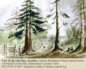
Jubilee Neighbourhood is relatively flat with arable soil, except for a low ridge of rock in the southwestern corner, on which the Pearse family built their home Fernwood in 1860 (demolished 1969). Bowker Creek crosses the neighbourhood from the northwest flowing to the southeast where it empties into the ocean south of Willows Beach. The creek and wells probably provided the water for the first farms in the area. In 1914 Bowker Creek flooded its banks and inundated what is now the intersection at Fort St. and Foul Bay Rd. Though portions of Bowker Creek are still exposed, the section through Jubilee flows in a covered culvert. In the late 1800s and early 1900s farming gradually gave way to housing, commercial and institutional uses.
The western boundary of the neighbourhood is an arbitrary one, following Begbie and Shelbourne Sts, which were connected into a major arterial route to downtown Victoria in the 1960s. An oddity in the neighbourhood is a finger on the northern edge which is a long, narrow panhandle to the east of Shelbourne, sandwiched between the Municipality of Saanich and Oakland Neighbourhood. The eastern boundary of Jubilee Neighbourhood is formed in the north by the boundary with Saanich and in the south by the boundary with Oak Bay. The southern boundary of the neighbourhood is Oak Bay Av and Gonzales and Rockland neighbourhoods.
Early Surveyor Benjamin W. Pearse and his Fernwood
Jubilee Neighbourhood lies mostly in the area purchased by treaty in 1850 from the Chekonein people whose main village was at Cadboro Bay. It was surveyed by colonial surveyor Joseph Despard Pemberton and his assistant, Benjamin W. Pearse. Pemberton purchased a huge tract of what is now Victoria and Oak Bay, stretching from the eastern end of Government House in Rockland Neighbourhood through Gonzales Neighbourhood all the way to the Victoria Golf Course along Beach Dr in Oak Bay. The full length of Jubilee’s southern boundary adjoins part of Pemberton’s property. Pearse purchased Sections 75 and 76 in 1853 (95 acres), north of Pemberton’s. All of Section 76 and a small portion of Section 75 comprise a major part of Jubilee.
Section 76 contains 100 acres bounded by Oak Bay Av, Foul Bay Rd, Bay St and a line running east of it through the Royal Jubilee Hospital grounds on the north and a line running just east of Shelbourne St along the west. Most of Section 75 is in Fernwood Neighbourhood, but a portion along Shelbourne and a wedge south of Begbie and east of Belmont is in Jubilee. The Pearse house Fernwood was a substantial stone building on a rocky ridge on what is now the south side of Begbie in Jubilee. “Fernwood” was the name applied to all of Section 75. Section 76 later became known as “East Fernwood.” Fernwood’s gatehouse stood where Sandringham Hospital is now.
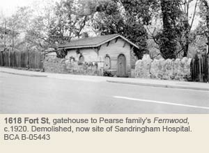
The Rev Robert J. Staines and North Jubilee
The northern finger of Jubilee comprises Section 8a, about 46 acres. It was purchased in 1853 by Rev Robert J. Staines, Hudson’s Bay Company chaplain and schoolmaster at Fort Victoria. He had another 400 acres in Metchosin, devoted considerable time to farming and was especially proud of his fine pigs. He was critical of Gov James Douglas and the governor was critical of the chaplain’s abilities as a teacher. In 1854 Staines was instrumental in circulating a petition against Douglas and was to deliver it personally to colonial authorities in London. However, he sailed on the Duchess of San Lorenzo which foundered off Cape Flattery and Staines perished. Section 8a was farmed, but not developed until the early 1900s. Many pre-1920 houses are located in the southern part. The northern part was undeveloped until the mid-20th Century.
Section 25 runs eastward from Section 8a toward Foul Bay Rd, mostly in Saanich. This land was originally purchased by the Roman Catholic Church in the name of Bishop Modeste Demers. Only the southwestern quadrant of Section 25 is in Jubilee Neighbourhood.
Early Farmers the Vyes and the Lees
Section 25 was purchased in 1885 by Alexander and Margaret Jane Vye. Their Richmond Farm was a dairy and potato farm. Richmond Rd (originally Mt. Tolmie Av) runs through the middle and forms part of the boundary between Victoria and Saanich. Their first house was of brick (demolished), but their second one still stands (1785 Carrick St). The farm was subdivided and by 1902 streets were laid out to the west of Richmond Rd, eventually connecting to Shelbourne St. The streets at first were numbered (Burnside and Hillside-Quadra Neighbourhoods had streets with similar names), but later renamed. First St became Emerson; Second, Adanac; Third, Haultain; Fourth, Carrick; and, Fifth, Kings. There was no Sixth, but Newton is where it would have been, forming the northern side of Section 25 and part of the northern boundary of Jubilee Neighbourhood. This area started filling in with houses by the 1890s and early 1900s, though many vacant lots remained for years.
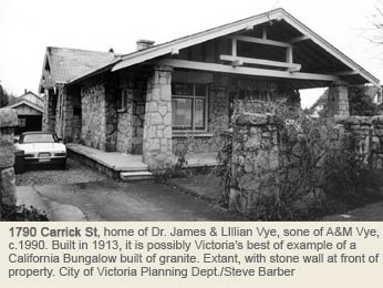
Early pioneers Thomas and Marietta Lee, an English couple, bought a large portion at the eastern side of Section 76 in 1868 (south of Fort St and west of Foul Bay Rd.) They established the Victoria Dairy and experimented with growing hops. Thomas died in 1880, and Marietta and her sons continued to farm, but gradually subdivided their property in the early 1900s.
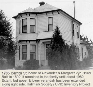
Royal Jubilee Hospital and the Electric Streetcar Lines
The Finnerty brothers, Michael and John, acquired a large tract along the western side of Section 76 (north and south of Fort St along Richmond Rd, including the site of Royal Jubilee Hospital). They were from County Mayo, Ireland, and came to British Columbia for the early 1860s gold rush. They operated a market garden and feed business, supplying Victoria and the Lower Mainland. Michael Finnerty also bought a large tract in Gordon Head, now partly occupied by the University of Victoria and Finnerty Rd, but the family home was in Jubilee Neighbourhood, closer to town, at what became 1530 Bank St.
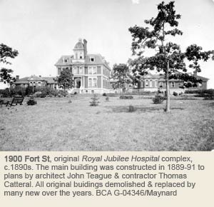
The creation of Royal Jubilee Hospital, which opened in 1890, was the single biggest factor in the development of Jubilee Neighbourhood (1900 Fort St). As late as 1920 the hospital maintained its own kitchen garden and raised pigs and chickens on what it termed “the Farm,” but complaints from the growing number of neighbours eventually brought an end to the rearing of livestock.
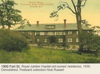

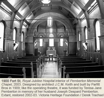
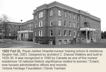
The opening of the Hospital coincided with the inauguration of the electric streetcar system which was instrumental in encouraging many subdivisions. One of the original lines ran along Fort St to the new hospital. In 1891 the line was extended to Driving Park (later Willows Fairgrounds) in Oak Bay and later, to Uplands. Other lines added in 1891 included one along Oak Bay Av to Windsor Park, which opened up the southern sector of Jubilee and the northen edge of Gonzales. The intersection where it branched off from the Fort St line became known as the Oak Bay Junction. In 1908 another spur line was laid from Fort St along Richmond Rd to Mt. Tolmie for hauling sand and gravel. Limited passenger service was started along the line to serve University School, but eventually full passenger service was introduced. A streetcar shelter, now in the couryard, is a reminder of Victoria’s streetcar era that ended in 1948.
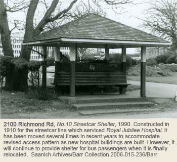
Main Roads and Residential Development
The original major roads through Jubilee are Oak Bay Av (formerly an extension of Pandora Av), laid out by J.D. Pemberton in 1890, and Fort St (formerly Cadboro Bay Rd). The houses built along these main routes tended to be more showy than those built along the side streets. After 1891 one of those who built along Oak Bay was architect A. Maxwell Muir. His Italianate cottage Bremhill was moved around the corner to 1511 Bank St. and altered, but it still stands. Isolated houses were constructed in the 1890s, but the biggest boom was from 1908-12 in Section 76 north of Oak Bay Av. Gessman & Pike, a land development company, acquired a large portion of the Lee farm and advertised lots along Foul Bay Rd, Bourchier St and Amphion St in 1908. Corner lots were $160, others were $140. By 1900 the Fernwood Syndicate was buying and selling land west of Richmond Rd, including the “tree” subdivision north of Fort St: Chestnut, Oak (now Ashgrove) and Maple (now Birch). Two of the oldest houses along the Jubilee section of Fort St were imposing Queen Anne structures built almost across from each other in the 1890s (1718 Fort St; 1739 Fort St).
One of the anomalies in Jubilee is the wedge in the southwestern corner that extends as far west as Belmont Av. This was where the Pearse house stood and most residents probably consider it to be part of Fernwood Neighbourhood. In the 1880s Major Charles T. Dupont, businessman, member of the Militia and one-time president of Victoria Electric Railway Co and Victoria & Esquimalt Telephone Co, purchased a large property from Pearse, mostly west of Belmont Av in Fernwood Neighbourhood, but a strip ran along the east side of Belmont in Jubilee. His home and estate were called Stadacona. Before Pandora Av opened, Dupont created a small subdivision and opened Stadacona Av around it on two sides. Only the western side remains. An extension of the original Stadacona Av (now covered by Stadacona Park) forms a line with Cold Harbour Rd in Jubilee. The origin of the name of this dead-end street is a mystery because it is far away from the ocean. Perhaps the name was inspired by Dupont’s speculation in land at Vancouver’s Coal Harbour when the CPR was being built. The Billings house (1528 Cold Harbour Rd) is an Arts & Crafts gem hidden at the end of this unusual street.
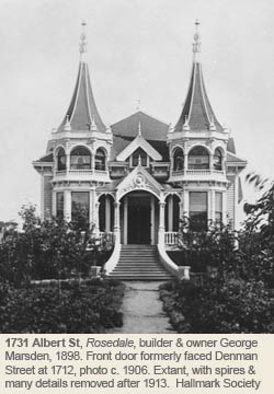
Churches, Schools and Firehall No. 8
The early development of Jubilee and nearby districts prompted the founding of two churches, in addition to the Royal Jubilee Hospital’s Pemberton Chapel (1900 Fort St). In 1892 the Christian Endeavour Society of St. Andrew’s Presbyterian Church built a modest frame church designed by A. Maxwell Muir at what is now 1602 Redfern St. Later the congregation became St. Columba’s Presbyterian Church on Oak Bay Av and eventually moved to what is now Oak Bay United Church. The Redfern St church became a Masonic Lodge, a Scout hall and is now a residence. In 1913 the Religious Society of Friends (Quakers) purchased land at 1831 Fern St and built a Meeting House. Still in use, it is the oldest continuously operating Friends meeting house in BC. In 1951 St. Barnabas Anglican Church moved to the southeastern corner of Belmont and Begbie from Cook and Caledonia. Plain concrete blocks on the outside, the church contains a rare hanging rood screen and a replica of Our Lady of Walsingham shrine, used by pilgrims in Norfolk, England, since the 12th Century.
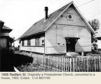
The first school in Jubilee was a small private boys’ school opened in 1898 by Rev. William Washington Bolton in rented premises on Belcher St (between Fort St and Oak Bay Av.) In 1906 he joined forces with James Barnacle whose University School was nearby in Rockland (corner of Oak Bay and Richmond). In 1909 the school moved to a new campus at Mt. Tolmie. In 1908 a private girls’ school, St. Margarets, was founded on Cook St. In 1912 it moved to the corner of Fort and Fern St in Jubilee. The property was bought from Pearse’s widow, Sarah Jane. Francis Mawson Rattenbury designed the new school which opened in 1912. The school moved to Saanich in 1970 and the old structure was torn down to build an apartment block. The only public school in Jubilee is Bank St School (1625 Bank St), built in 1910-11.Fire Hall No.8 was built in 1911 at the corner of Leighton and Duchess, kitty corner from the school yard of Bank St School. It provided protection to the Jubilee Neighbourhood and adjacent areas, including Oak Bay, until that municipality created its own fire department in 1937. Loss of funding from Oak Bay and the general difficulties during the Depression forced the closure of Fire Hall No.8 in 1937. After that calls from Jubilee were handled from Fire Hall No.2 on Yates St and later from Fire Hall No.1 on Cormorant St (where Centennial Square is today). Fire Hall No.8 was enlarged and converted to an apartment building which still, minus its tower.
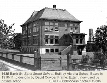
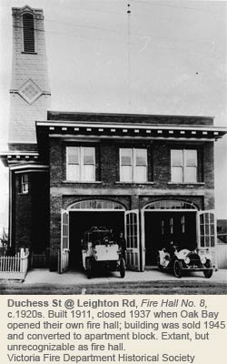
Commercial Centres
Jubilee contains several small commercial centres, generally coinciding with the streetcar lines and major intersections. One of the oldest commercial hubs is at the Oak Bay Junction. (Yokohama Pressers, 1608 Fort St). Another is at the corner of Fort St and Richmond Av, close to the hospital, Turner’s Confectionery, opened in 1937, is a landmark building at the corner and many generations of nurses from the Royal Jubilee enjoyed the welcome given to them by “Ma Turner.” Her son, Ian, started a coffee shop beside the store in 1945 where student nurses from Begbie Hall (1900 Fort St) across the street sat on their days off. Though Turner’s is now closed, the building still stands (update: demolished in 2025). Another commercial strip has grown up along Oak Bay Av. Today Jubilee’s biggest retail area is at the corner of Fort and Foul Bay, where Canada Safeway opened its first supermarket in the late 1960s, a site occupied until then by the Victoria Lawn Tennis Club. The club’s original premises were in Rockland, but moved to Jubilee in 1910. It changed its name to the Racquet Club when it moved to Gordon Head Rd in the 1960s.
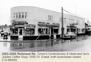
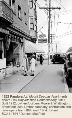
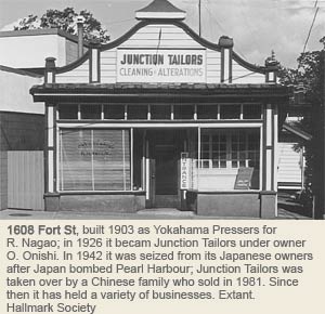
Heritage Register Properties
18 Jubilee properties on the City of Victoria's Heritage Register in 2026
Heritage-designated - Protected by bylaw. Houses eligible for VHF funding.
Heritage-registered - Not protected, may warrant future preservation. Houses ineligible for VHF funding.
Heritage covenant - Protected by legal agreement. Houses eligible for VHF funding.
NHS - National Historic Site
1784 Adanac St
Registered
1731 Albert Av
Designated 2012
1625 Bank St
Registered / Institutional
1785 Carrick St
Designated 1985
1790 Carrick St
Designated 1991
1528 Coldharbour Rd
Registered
1728 Denman St
Designated 2016
1741 Duchess St
Designated 1995
1829-31 Fern St
Designated 1990
1857 Fern St
Designated 1996
1871 Fern St
Designated 1996
1608 Fort St
Registered / Commercial
1718 Fort St
Registered
1739 Fort St
Registered
1900 Fort St / 2100 Richmond Av
Registered / Institutional / NHS
1900 Fort St – Memorial Operating Theatre
Designated / NHS
1900 Fort St – Memorial Chapel
Designated / Institutional / NHS
1900 Fort St – Bus Shelter
Registered / Institutional
2536 Richmond Av
Designated 2021
Oaklands
By Maryanne McGrath © 2007 Victoria Heritage Foundation
Oaklands is an expansive and primarily residential neighbourhood in the NE corner of Victoria, bounded by North Dairy, Shelbourne, Haultain, and Cook Streets. The majority of development occurred between WWI and WWII, and before this, vast sections of the area west of Bowker Creek and the Hillside Shopping Centre area were farmland. There were areas of swampland along Haultain Street.
Early Farms & Nurseries
When the City was surveyed in the 1850s, the land north of Ryan St, later known as Section 29, was allotted to John Ross and he called it Oakland Farm Estate. The land south of Ryan Street became part of Roderick Finlayson’s estate. Section 48, as it was later known, remained in the family until the early 1900s.
John Ross was the eldest son of Isabella and Charles Ross, Hudson Bay Co Chief Trader in Charge at Fort Victoria. After Charles died in 1844, John became Roderick Finlayson’s assistant. John married Genevieve Plamondon, daughter of Simon Bonaparte Plamondon who worked for the HBC at Fort Langley c.1827-1830. John and Genevieve cleared land among the Garry oak meadows for Oakland Farm, built a substantial farmhouse, and had at least six children between 1854 and 1862. John died in 1863 at 41, and Genevieve lived on Foul Bay Road, likely at the Ross farm in Ross Bay, through the 1870s. Oakland Estate became the property of the HBC by 1866, and farm manager Mr. Harvey produced quality crops for the company.
Twin Oak Farm was about 82 acres on Cedar Hill Road near or part of the Oakland Estate. It was possibly established in 1856 by John McDougal, who later moved to the Okanagan with his aboriginal wife Emilie and their sons. Charles Alfred Bayley owned the farm for 14 months, but sold because it didn’t make money. Bayley was variously a hotelier, teacher, and MLA. He left for San Francisco in the 1860s and died there in 1889. George Tomline Gordon bought the farm in 1861, and then it was sold at government auction in 1862. It was auctioned again for Lewis Dodgson, cattle dealer, in 1866, although he was still listed as a farmer at Twin Oak Farm in 1871. John Burrowes, who came to Canada from England in 1865, was the leaseholder in 1875, and died there in 1882 at 78. The farm was then sold for $6,000, likely to Napoleon Sabin (1845-1911). He came to BC from Quebec with his Scottish wife Margaret (1852-1888) in 1861, then to Victoria and won a paving contract for Wharf St. Margaret died at Twin Oak, Napoleon married Catherine Farrington in 1889, and lived on the farm until c.1900. He died in Colwood.
Area pioneers included Andrew Ohlson (1846-1930) and wife Palla (Neilson, 1850-1933) who came to BC from Sweden in 1875. They lived at 1580 Hillside Avenue at Doncaster Drive until their deaths. Neighbours across the street, George and Cecilia Powers, later moved to 1431 Vining St (Fernwood). The Ohlsons established Oaklands Nurseries shortly after their arrival, and operated it until their deaths. During his lengthy career Andrew was also a BC Government fruit inspector. Oaklands Nursery was in operation until the late 1950s, and several large greenhouses occupied lots at Doncaster and Hillside. A Chinese-owned vegetable garden was located next to the nursery at the end of Scott Street. Hillside Shopping Centre was built on this site in 1962.
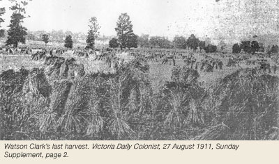
Watson Clark (1845-1913) came to Victoria from England with his wife Jane (Westall, 1851-1935) in 1887. He farmed on the north side of what is now Oakland Avenue, near his house at 2821 Gosworth Road. Watson was a successful wheat farmer, and when he retired in 1911, his was the last field within Victoria city limits. After his death, the land was subdivided and many houses were built. Jane moved to Shawnigan Lake, where she died in 1935.
Oaklands Hotel 1864-1871
Although Oaklands was primarily rural during its early history, there were at least a handful of non-agricultural establishments in the area. The Oaklands Hotel opened on Cedar Hill Road in 1864. Aimé Leclaire (1829-1886) was the proprietor for several years, with his wife Maria Grant. Leclaire had been an overseer of Finlayson’s Farm in the late-1850s, and later operated a nursery garden on Cedar Hill Road, which he sold in 1872. The hotel burned down in 1871 during a ball while William Farron (916 Pandora Av, North Park) was the owner.
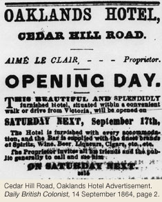
Early Roads & Transportation
The majority of the roads running through Oaklands were not created until subdivisions were developed in the early 1900s, but Cedar Hill Road’s existence dates to the early 1850s as it led to Cedar Hill (now Mt Douglas) where HBC men hunted, and the early farms in what is now Gordon Head in Saanich. Hillside Av was also built quite early, but existed as Lan(d)sdowne Road east of Cedar Hill Road until 1912. Gosworth Road, Edgeware Road and Shakespeare Street (originally Amethyst Street – it once ran all the way through to North Dairy Avenue) all date back to the 1890s. The portion of Doncaster Drive below Hillside Avenue was called Ruby Road until the early 1900s. Shelbourne Street, named after Governor General Lord Shelbourne Lansdowne, originally developed as a route for Gordon Head farmers and was improved in 1915. Trees planted on Shelbourne Street in 1921 are a memorial to WWI soldiers.
Before the streetcar line came up Hillside Avenue to Cedar Hill Road in the early 1900s, public transportation to the northern portion of the neighbourhood was lacking, although entrepreneurs operated private stage lines to the neighbourhood. W.B.C. Mewburn ran The Mount Tolmie & Oaklands “Tally Ho” Stage in the 1890s. Mewburn was a carpenter in James Bay in 1892. By 1895 he was living in Oaklands as postmaster and proprietor of a grocery store. He appears to have left the City by 1900.
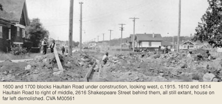
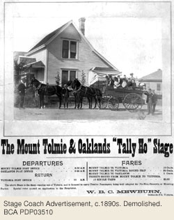
Subdivision & Development 1909-13
Although the area was surveyed as residential lots in the 1880s, the first significant building boom wasn’t until 1909-13. As older farmers died off, their properties were subdivided into residential lots. Auction sales were common, and in June 1909 the area bounded by Ryan Street, Haultain Street and Kings Road on the former Finlayson Estate was subdivided and sold. Henry Emmanuel Levy (2667 Empire St) developed 24 lots on Edgeware Road in 1912-14. Although known for his restaurant on Government Street, he also dabbled in real estate, owning over 50 houses in the City at one point. Another development known as the Hillside Addition was built in 1913 between North Dairy Road and Hillside Avenue, beside Oaklands Nursery where Hillside Shopping Centre is today. These developments catered to moderate-income earners, and were valued for being within City Limits, and the new residents were accommodated by an extension of the streetcar line along Hillside Avenue.
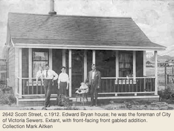
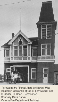
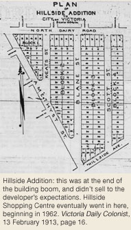
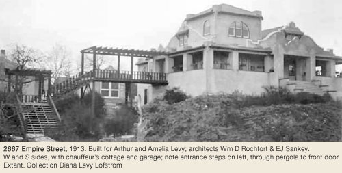
Institutional Development
The Jewish Cemetery west of Cedar Hill Road near Ryan Place was consecrated in 1859, 13 years before Ross Bay Cemetery was founded. The Jewish Cemetery remained quite isolated until the early 1900s, when residential development began in the area. The BC Protestant Orphanage, now Bishop Cridge Centre (1190 Kings Rd), opened at Cook Street and Hillside Avenue in 1893.
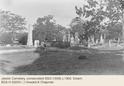
The pre-WWI population boom increase resulted in the construction of Oaklands School (2827 Belmont Av) in 1913, and the demand for local religious services. The Christian Brethren established a Sunday school at the Galloway home at 1250 Acton Street (extant) in 1911. The following year, Gospel services were held above a shop at the corner of Cedar Hill Road and Hillside Avenue. Families from Victoria Gospel Hall on Blanshard Street saw the need for a new assembly, and Oaklands Gospel Hall was built at 2815 Cedar Hill Road in 1914. Further growth resulted in 1956 in the Oaklands Chapel at Fernwood and Cedar Hill Roads. The Good Shepherd Lutheran Church presently owns 2815 Cedar Hill Road.
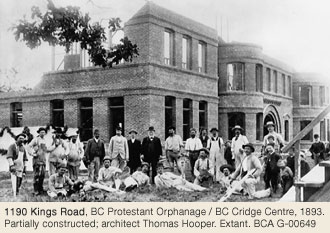
The Oaklands Methodist (United) Church was built at 2841 Gosworth Road in 1913. It became the United Church Sunday School in the early 1940s. By 1975, it was Gosworth Road Community Church, and is now the Chinese Alliance Church. The Anglican Diocese built the Church of St. Mary Magdalene at 2801 Gosworth Road in 1915, as part of St. Alban’s Parish; it originated as Oaklands Mission in 1913. In 1925 the Parish was transferred to St. Barnabas. St. Alban’s, independent since 1946, is now at 1468 Ryan Street.
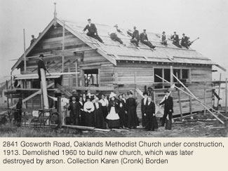
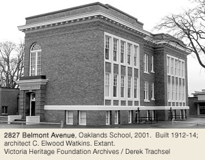
1935 Flood
In 1935 Victoria was hit by three days of devastating rainfall. Up to four feet of water flooded the low-lying areas of Fernwood and Oaklands. Economic conditions of the Great Depression did not allow for much compensation for the many homes and businesses damaged by the flooding. Bowker Creek runs down along Shelbourne Street and Maplewood Avenue (Saanich) and joins at North Dairy Road at Doncaster Drive. The main creek flowed along Doncaster Drive where Hillside Shopping Centre is today. Flooding was frequent in low-lying regions, particularly near North Dairy Road and along Shelbourne Avenue and Haultain Street. Problem areas were eventually re-routed to flow through concrete culverts.
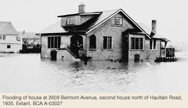
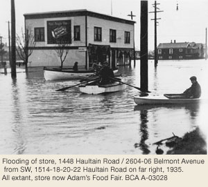
Post World War Two Building Room
Oaklands’ next building boom took place during and after WWII, with many examples of wartime and veterans’ housing in the area, particularly on Shakespeare Street, Scott Street, Oakland Avenue, Hillside Avenue, Edgeware Road, Myrtle Avenue, and Kings Road. In 1950 the Victoria Kiwanis Club established the City’s first Seniors’ housing initiative on an 8-acre site between Cook Street and Cedar Hill Road. The development of Hillside Mall was begun in 1962 by Bentall: they built an enclosure for a number of independent businesses which had existed on the site and built the large Sears store. During the 1960’s and ’70s the great boom in apartment blocks throughout Victoria affected Oaklands only slightly, but the more recent condominium building boom starting in the 1990s is particularly evident along the main trunks of the neighbourhood such as Hillside Avenue.
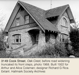
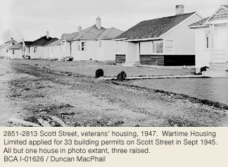
Heritage Register Properties
10 Oaklands properties on the City's Heritage Register in 2026
Heritage-designated – Protected by City bylaw. Houses eligible for VHF funding.
Heritage-registered – Not protected, may warrant future preservation. Houses ineligible for VHF funding.
Heritage covenant – Protected by legal agreement. Houses eligible for VHF funding
2744 Avebury Av
Designated 1989
2827 Belmont Av
Registered
3149 Cook St
Registered
1531 Edgeware Rd
Designated 2013
2667 Empire Av
Designated 1985
2645 Fernwood Rd
Designated 2002
2663 Fernwood Rd
Registered
2711 Fernwood Rd
Designated 1991
1481 Finlayson Pl
Designated 2001
Hillside-Quadra
By John Adams © 2004
The name Hillside-Quadra is derived from two of the neighbourhoods’ principal streets that run east-west and north-south respectively, dividing the community into quadrants of unequal size. The names evolved from two sources: Hillside Farm (which occupied most of the area) and the 18th Century Spanish explorer Juan Francisco de la Bodega y Quadra (who never set eyes on any part of Victoria). The land rises generally from south to north, with the highest portion being in the northeast, variously called Work’s Rocks, Summit Hill or Smith’s Hill. A stream flowed from east to west, close to the southerly edge, just north of Bay Street. It drained from Harris Pond in Fernwood and flowed into Rock Bay. The neighbourhood boundaries are Bay Street on the south, Cook Street on the east, Blanshard Street on the west and Tolmie Avenue (the dividing line between Victoria and Saanich) on the north. In some ways these boundaries seem artificial because they do not follow the natural features in the landscape, but slice right through them or divide some neighbourhoods (e.g. north and south of Bay Street, east and west of Cook Street and east and west of Blanshard Street). When viewed in the context of early land ownership, however, they are quite logical.
John & Josette Work & Their Hillside Farm
Except for a narrow piece near Topaz Park, the entire Hillside-Quadra neighbourhood comprises the eastern half of Section IV of Joseph Despard Pemberton’s 1851 survey of Victoria. All of Section IV was purchased by Hudson’s Bay Company (HBC) Chief Factor Hon. John Work (Wark) in 1852 from the HBC. It was a tract of 583 acres, for which he paid the going rate of £1 per acre (minus standard deductions for unproductive rock and swamp). He also purchased other lands around Mount Tolmie and in Gordon Head, making him the owner of over 1,300 acres in total and the largest landowner in the Colony of Vancouver Island. He called Section IV Hillside Farm and used it as his base farm where he built his family home.
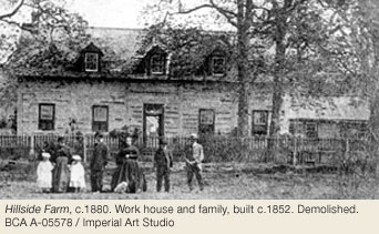
The Works’ farmhouse (demolished) was located near what is now the corner of Vancouver Street and Kings Road, included in a complex of other farm buildings. The driveway angled off Quadra Street in a north easterly direction just a few doors north of Bay Street. It was built in the typical piece-sur-piece squared log construction of the HBC, a substantial 1½-storey house with three dormer windows.
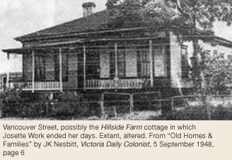
The Work family was large and known for its hospitality. John Work, a Presbyterian from Co. Donegal, Ireland, joined the HBC in 1814 and was a lifelong employee of the fur trade. His wife was Susette “Josette” Legacé, daughter of a French Canadian HBC employee and a Spokane woman. They had 12 children, four boys and eight girls, the daughters being one of the main attractions that drew many young men to dance, ride, or dine at Hillside in the days following the 1858 Fraser River Gold Rush. John Work died in 1861 and Josette in 1896. Son Henry (1844-1856) died of an accident and may have been one of the last to be buried in Pioneer Square (Fairfield). John (1839-1886) and David (1846-1878), were a disappointment, the elder being a drunkard and the younger one being described by John Tod as a “despicable character.” [John, Henry and David Streets in Burnside were named for them.] The Work daughters fared socially and economically better than their brothers, most marrying prominent men of means. Eventually the sisters or their heirs inherited all of the family’s remaining land in Section IV.*
* Some Work family research by descendant Pam Gaudio.
Hillside Extension Subdivision 1885
The first subdivision of Hillside Farm was in 1885 when the “Hillside Extension” was laid out, bordered by Bay Street, Douglas Street, Hillside Avenue and Quadra Street. The names of the north-south streets were First Street (later Rose Street, now Blanshard St), Second Street (now Dowler Place), Third Street (now Wark St) and Fourth Street (now Quadra St). Kings Road was the original main east-west thoroughfare through the subdivision. Houses soon began to appear in the “Hillside Extension” for a very diverse mix of people. The finer homes were built along Douglas Street and west of First Street. One of the most prominent residents was Noah Shakespeare, mayor and Member of Parliament in the 1880s, whose attractive Queen Anne-style house, Stratford Villa (demolished) stood at the corner of Second Street and Hillside Avenue. By the early 1900s the subdivision was built out, mostly with modest frame houses for tradesmen and middle class families.
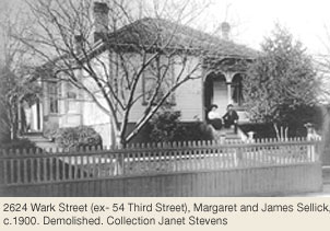
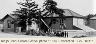
North Ward School (demolished, see Burnside History, This Old House Three) opened in 1894 on Douglas Street to serve the growing neighbourhood. Hillside School, later called Kings Road School, (demolished, now a park at the southeast corner of Wark Street and Kings Road) was built in the early 1900s as a two-room frame structure to help ease overcrowding at North Ward. When Quadra Street Primary School (2549 Quadra St) opened in 1921, Kings Road School became a segregated facility mainly for Chinese; by the 1940s it was the Dominion-Provincial School of Auto Mechanics.
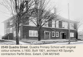
Development of Blanshard Street Thoroughfare
Virtually nothing remains of the original houses in the “Hillside Extension” because the Urban Renewal Report in 1961 recommended that it be the city’s first priority for redevelopment. Citing the fact that 127 houses (representing 97% of the total) were constructed before 1912 and that 76% of them were in “poor” condition, it advocated their total demolition and replacement with 120 units of community housing to be funded jointly under a federal-provincial scheme. The concept was approved and Blanshard Court was built, with 157 families being displaced in the process. North Ward School was demolished and Blanshard Elementary School was built for the children of the project and nearby neighbourhoods. The structure is now used as a campus for the University of Canada West.
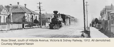
One of the reasons for clearing the “Hillside Extension” was to create a new access road into Victoria due to increased traffic from the Swartz Bay ferry terminal following the start of BC Ferries in 1960. Previously the main routes into the city from the north were Douglas Street or Quadra Street. Blanshard Street was not a through street until after the redevelopment when it was extended north as a dual carriageway, along what had been Rose Street (previously First Street). The new route also more or less followed the right-of-way of the Victoria and Sidney Railway that had opened in 1894, originally as far as Hillside Avenue and eventually into downtown Victoria. Part of the railway ran along city streets. After the railway ceased to operate in 1919 the tracks were removed. Blanshard Street soon became a busy thoroughfare that effectively created a barrier between the Hillside-Quadra neighbourhood and the once contiguous neighbourhoods to the west.
Topaz Area: Hillside Gaol to SJ Willis Junior High & Brickyards to Mayfair Mall
One of the dominant buildings in the neighbourhood was the red brick Hillside Gaol, sometimes called Topaz Jail, and situated in a grove of Garry oak trees on a rocky slope north of Hillside Avenue. The three-storey central block with two wings looked over the “Hillside Extension.” The 66-cell structure opened in 1885 to replace the cramped and crumbling Police Barracks and Gaol in Bastion Square. Following a fire in 1912 it was demolished and the remaining foundations afforded neighbourhood children a place to play hide and seek and to hunt tadpoles when the cavities filled with rainwater. S.J. Willis Junior High School was built on the site in 1949.
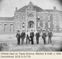
Between the Hillside Gaol and Quadra Street was a subdivision called “Hillside Extension A.” Its most imposing house was Allandale at 818 Hillside Avenue, the private home of James Graham and Mary Work. Designed by John Teague it was built in 1884 and demolished in 1927.
North of “Hillside Extension A” and the jail, cutting into Hillside Farm, was a thin strip of land along Topaz Avenue, officially known as Section V. Part of Topaz Park is there now. Originally it was owned by Robert Clouston, another HBC employee, but changed hands after his death in 1859. In the 1860s William and Charlotte Galley built a 2-storey house (demolished) on a portion of the property that sloped down to Quadra Street and a large swamp. On a dark, windy night one of the Galley daughters, Alta Louisa, heard someone calling out. When the family went to investigate they found an intoxicated man stuck up to his armpits in the mud. On another occasion one of the Galley’s cows grazing on the rocky bluff behind the gaol slipped over the precipice onto Topaz Avenue and died.
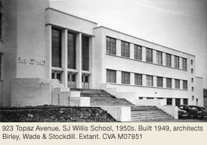
Further north, where most of the main playing fields of Topaz Park are now, was a rough, swampy area that supplied clay to the brickyards that operated west of what is now Blanshard Street. The last brickyard, operated by Evans, Coleman and Evans, closed in 1961 to make way for Mayfair Mall. To the east of this “wild” land, along both sides of Quadra Street, an avenue of substantial homes was developed from 1900 onwards.
Further Subdivision of Work’s Hillside Farm - 1890s to 1940s
Before the death of Josette Work in 1896, land east of Quadra Street and south of Hillside Avenue, closer to her Hillside farmstead, was subdivided and sold, the first houses being built around 1892. Most were modest frame houses in modified Queen Anne and Italianate styles for working class families.
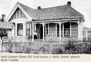
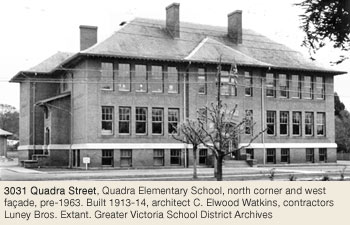
The system of numbered streets was continued east of Quadra Street, adding Fifth through Ninth Streets. In 1905 the names of all the numbered streets on both sides of Quadra Street, except Fifth, were changed. Most of the ones east of Fifth Street were given the married names of six of John and Josette Work’s daughters or granddaughters. The new streets were: Vancouver (Sixth), Graham (Seventh), Prior (Eighth) and Blackwood (Ninth). They radiated off Kings Road since access to Bay Street was blocked by the stream until some time after 1907. From 1892 until 1912, block after block of houses was constructed along these streets. George Jay School on Cook Street (1118 Princess, Fernwood) served the elementary-school-age children of the neighbourhood. Commercial services for the area developed around the intersection of Hillside Avenue and Quadra Street. Several industries located nearby, such as Canadian Bakeries, which had its principal bakery and stables at 2629 Prior Street, with frontage also on Blackwood.
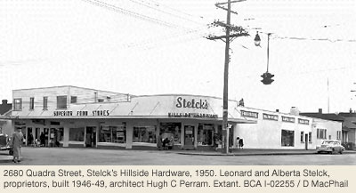
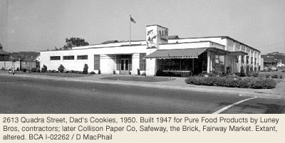
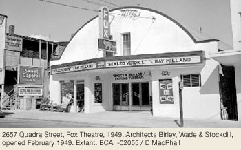
Smith’s Hill & Hillside Extension C
The land east of Quadra Street and north of Hillside Avenue, rising to the summit of Smith’s Hill, was subdivided in the late 1880s but generally not developed until after 1900. The hill is named after William J. Smith, partner in the building contractors Smith & Elford (they also operated Victoria Brick & Tile Company, one of several brickyards at the present-day site of Mayfair Mall.) Smith built a substantial brick house and stables on Montrose Avenue in 1892. In 1923 the property was purchased by former Victoria mayor A.J. Morley (who lived at 1246 Montrose) & turned into Sunhill (TB) Sanatorium. The building was demolished in 1936.
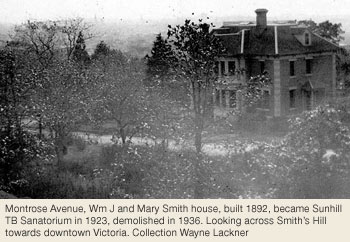
Most of Smith’s Hill was called “Hillside Extension C.” Here the married names of three more Work daughters were given to streets: Tolmie, Finlayson and Jackson. The reservoir at the top of the hill was opened in 1909 as part of a plan that included the water tower in Rockland. Both were intended to improve the pressure of the city’s water supply drawn from Elk Lake until the new Sooke Lake Reservoir was created.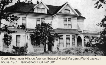
Halfway up the slope, at the corner of Topaz Avenue and Blackwood Street, the Khalsa Diwan Society purchased four lots in 1909 for the purpose of building a Gurdwara (Sikh temple). Mayor John Beckwith owned property nearby and opposed the plan. When civic officials withheld a building permit the Sikh community won a legal action against the city and work proceeded in 1912 on a concrete-block and brick Gurdwara designed by Henry S. Griffith, architect. The temple was largely rebuilt in 1969. When the cut stonewall around Sunhill Sanatorium was taken down in 1936 the stones were moved by horse and cart and by hand to the Gurdwara where they were used to build a new wall, still in place.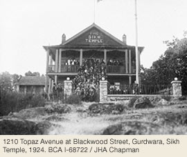
Smith’s Hill mainly developed as a fashionable middle and upper-middle class residential neighbourhood during the years between 1905 and 1912, before an economic depression brought an end to most new construction. From 1911-1914, roughly at the same time Henry S. Griffith was designing the Gurdwara, he was building his own stately home, Fort Garry (now Spencer Castle, 2906 Cook St) nearby on a ridge overlooking Cook Street. Other houses built in this period include: 1052 Topaz, 1310 Topaz, 2715 Blackwood, 2733 Blackwood and 1150 Summit Avenue, which was designed by F.M. Rattenbury. Quadra Elementary School (3031 Quadra St) designed by C. Elwood Watkins, opened in 1914 to serve the students of the Smith’s Hill area and other nearby subdivisions.
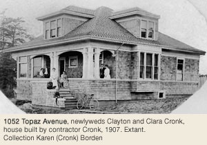
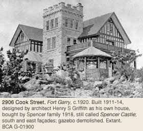
Topaz Heights by Beth MacDonald ©2007
The last part of Hillside-Quadra to be developed was Topaz Heights. These were originally 101 rental houses of five designs built between Quadra Street, Tolmie Avenue and Finalyson Street in 1946-47 for returning veterans by Housing Enterprises Canada Ltd (HECL), mandated and financed by the Federal Government, and operated by insurance companies. HECL built 3,200 units in 24 cities across Canada and it is believed that these designs were only built in Victoria. HECL’s other designs were Cape Cod and cottages similar to those used by Wartime Housing Ltd. Due to rising costs of materials and labour, HECL’s projects were transferred to Central Housing and Mortgage Corporation (CMHC) in 1947.
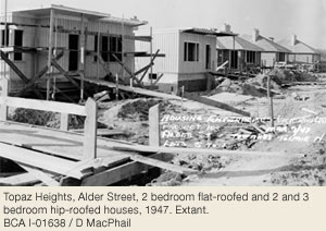
Architecturally, Topaz Heights represents the first foray into mass, domestic modern architecture in Victoria. While other houses and subdivisions were built in Victoria at this time none have all the elements of Topaz Heights. First, instead of being built scattered about town during and after the war as the Wartime Housing Ltd homes were, these houses were all built in the same place at the same time. Second, instead of using the conventional grid street pattern, modern planning is evident not only in the two pleasant curves interrupting the grid layout but also the park and inter-street paths. Third, rather than the mix of newly-married families with young children, with teenagers, and the retired, all the residents were young married veterans with small children. Finally, Topaz Heights was geographically enclosed as Finlayson turned into a trail at Yew, the gravel pits were on the south and the brickyard east behind Alder, leaving Tolmie and Quadra Streets as the through streets on the edges of the neighbourhood. All these factors resulted in a very cohesive neighbourhood of both new and existing homes. Even pushing through Blanshard and Finlayson Streets in 1963 and further widening of Finlayson did not damage the neighbourhood’s integrity.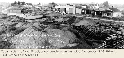
Heritage Register Properties
18 Hillside-Quadra properties on the City of Victoria's Heritage Register in 2026
Heritage-designated - Protected by bylaw. Houses eligible for VHF funding.
Heritage-registered - Not protected, may warrant future preservation. Houses ineligible for VHF funding.
Heritage covenant - Protected by legal agreement. Houses eligible for VHF funding
2715 Blackwood St
Designated 1988
2733 Blackwood St
Designated 2007
2906 Cook St
Registered
2736 Fifth St
Designated 2003
1302 Finlayson St
Registered
2564 Graham St
Designated 2021
2587 Graham St
Designated 2009
1231 Montrose Av
Designated 2013
2549 Quadra St
Registered
3010 Quadra St
Designated 1989
3012 Quadra St
Designated 1991
3020 Quadra St
Designated 1990
3031 Quadra St
Registered
3107 Quadra St
Registered
1052 Topaz Av
Designated 2004
1128 Topaz Av
Designated 2008
1290 Topaz Av
Designated 2012
1310 Topaz Av
Designated 2002
Vic West
By Julia Trachsel © 2004
Victoria West, affectionately known as Vic West, officially came into being in 1890 when by-law #124 redefined and enlarged the boundaries of Victoria. The new boundaries were in force for the 1891 census. It occupies a peninsula bounded by the scenic Gorge/Selkirk waterway, the Victoria Harbour, and the eastern border of Esquimalt. Its 155 hectares (380 acres) represents eight percent of Victoria’s land base.
Songhees First Nations Village 1853-1911
In 1844, the Hudson’s Bay Company’s (HBC) requested that the Songhees people build their village along the west shore of the Inner Harbour, across the water from HBC’s Fort Victoria. Their long plank houses covered the shoreline from Songhees Point to the north side of what is now the Johnson Street Bridge. This became a reserve in 1853 and was the main Songhees village before it was sold in 1911, and its inhabitants removed to the present site in Esquimalt. Today, the Delta Ocean Point sits on the site of Chief Cheetlam George’s home, and Songhees Point, where the Commonwealth Totem Pole now stands at the entrance to Victoria’s Inner Harbour, was known by the native people as Pallatsis, “place of cradle.” When their children learned to walk, families would place abandoned cradles along this point to ensure their children a long life. When they died, the deceased Songhees were laid to rest on the then treed islands off Victoria West’s coastline.
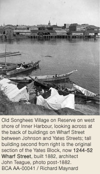
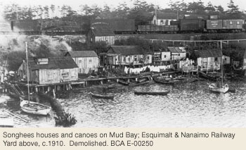
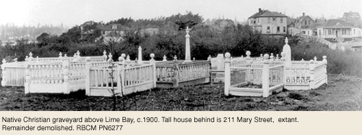
First Landowners Henry Simpson & John Russell
In 1858, the Fraser River gold rush made working on the HBC farms very unattractive, and many employees left to seek their fortunes. It was during this time that two former employees, Henry Simpson and (Robert) John Russell (505-07 Springfield St, Victoria West), purchased the only land in Victoria West that was not owned by HBC or used as a reserve.
Henry Simpson, born in Essex, England, acquired his rectangular piece of land in 1864. This parcel consisted of 45.8 acres and cost forty-four pounds and five shillings. It extended north from the Inner Harbour up to Craigflower Road, along the present day dividing line between Esquimalt and Victoria, and east to Russell Street. Simpson almost immediately sold his Victoria West property and bought 300 acres in Central Saanich, where he opened the Prairie Tavern, now the Prairie Inn, before clearing and farming his large property. John Russell’s property was 103.5 acres, and bordered Simpson’s on the west and the Songhees Reserve on the east. His purchase price was one hundred and three pounds, fourteen shillings and one penny! On four acres of waterfront property at the foot of what is now Russell Street, John built a large house with a wrap-around verandah and a driveway that encircled the house. His outbuildings included a barn for his livestock, a carriage house, and surprisingly, an outdoor dance pavilion, remembered fondly by old-timers. His house is alternately referred to as Russell House and Springfield House, depending on the source.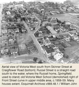
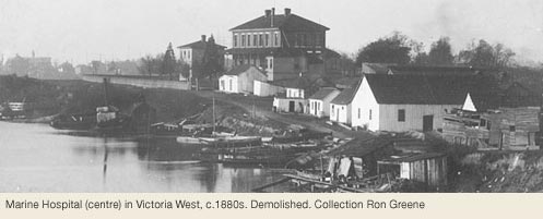
Bridges, the Railway, the Streetcar & the Bus
Bridges between Victoria West and Fort Victoria were put up and taken down depending on the politics of the day. They were built because Esquimalt residents wanted access to Victoria other than by boat, and taken down when the mix of Songhees and Fort Victoria newcomers created tension. Another problem was that a fixed bridge impeded vessel traffic up Victoria Arm to the ever increasing industrial areas, so for some time a ferry service operated between Lime Point and downtown.
In 1886, the Esquimalt & Nanaimo Railway’s (E&N;) Russell Station was built on the south side of Esquimalt Road between Catherine and Mary Streets. (That site was used again between 1972 and 1985.) It was a small rust-red building with one long slatted bench outside; nearby were a freight shed and cattle pen. In 1888 a swing bridge was built to provide the E&N; with access to its new terminus at the junction of Store and Pandora Streets, which was replaced in 1924 by the Johnson Street Bridge, designed by Joseph Strauss, who later designed San Francisco’s Golden Gate Bridge.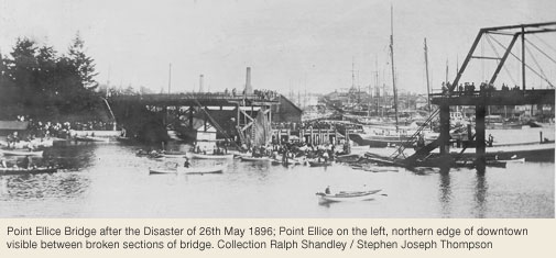
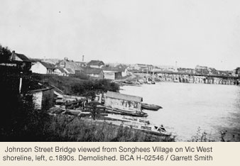
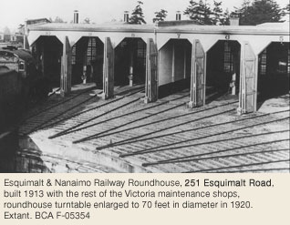
Elegant Homes for Businessmen
Victoria West was desirable for its direct access to the Inner Harbour and the Gorge, its hills with views to the Olympics, and its meandering shoreline dotted with sandy beaches. These attributes made it a favourite spot for the prominent families of the 1880s and ‘90s. Families such as Dunsmuir (coal and E&N; Railway), Gray (Albion Iron Works), Muirhead (lumber and milling), Troup (shipping), Barnard (BC Coast Steamship Company), Brackman (Brackman-Kerr Milling Co) and Fairall (brewers), all lived in elegant homes throughout Victoria West. Unfortunately, only Muirhead (223 Robert St), Brackman (1004 Catherine St), Gray (1135 Catherine St) and Fairall (505-07 Springfield St) homes still exist from this group, and the oldest Muirhead and Fairall homes are gone. The eventual demise of these large estates came partly with the institution of income taxes during WWI, which made many of them uneconomic for subsequent owners. Left empty, the homes deteriorated and were eventually replaced with modern versions.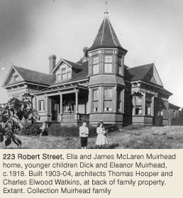
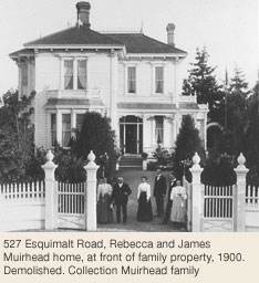
Sir Frank Stillman Barnard’s former house was located just inside the western border of Victoria West, overlooking the Straits of Juan de Fuca. The site is now Barnard Park, and the gateposts still exist at the park entrance. The high-rise Princess Patricia apartments, built in the mid-1960s, now stand on the site of the home of his neighbour, Captain Troup.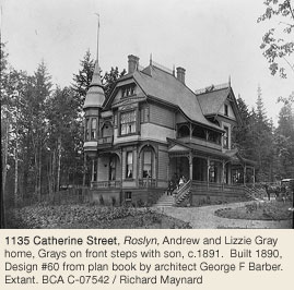
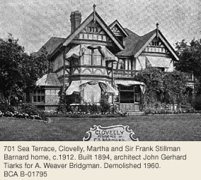
Burleith, James and Laura Dunsmuir’s home at 743 Craigflower Road, was the most grand of all the demolished houses in Victoria West. It burned to the ground on Halloween 1931, the result of children playing with firecrackers in what must have seemed like a haunted house after being vacant for some years. All that remains of the 20-acre estate are sections of stonewall along Craigflower Road, and the gatehouse. There were croquet lawns, tennis courts, and garden paths – a park-like setting designed by Scottish landscape designer John Blair of Beacon Hill Park fame.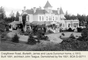
Sir Frank Stillman Barnard’s former house was located just inside the western border of Victoria West, overlooking the Straits of Juan de Fuca. The site is now Barnard Park, and the gateposts still exist at the park entrance. The high-rise Princess Patricia apartments, built in the mid-1960s, now stand on the site of the home of his neighbour, Captain Troup. Burleith, James and Laura Dunsmuir’s home at 743 Craigflower Road, was the most grand of all the demolished houses in Victoria West. It burned to the ground on Halloween 1931, the result of children playing with firecrackers in what must have seemed like a haunted house after being vacant for some years. All that remains of the 20-acre estate are sections of stonewall along Craigflower Road, and the gatehouse. There were croquet lawns, tennis courts, and garden paths – a park-like setting designed by Scottish landscape designer John Blair of Beacon Hill Park fame.
Industry & Jobs for Working Class Residents
The wealthy in Victoria West lived alongside the working class. The men were employed by the many industries wrapped along the shoreline, the E&N; and BC Electric Railway. After the Songhees people were removed to the Esquimalt Reserve in 1911, that land was designated for industrial use. At one point, there were seven companies simultaneously active in shipbuilding. Alongside these were lumber planing and sawmills, storage and wood drying mills, as well as machine shops and foundries. The Sidney Paper & Roofing Company, Shell, and Union Oil came later. Another employer was the CNR (formerly Northern Pacific). The derelict station house can still be seen on the west end and just north of the Point Ellice Bridge. The CNR yards were completed in 1920, and included a five-stall engine house, workshops, coaling facilities, water tower, station and freight shed. From 1922-31, passenger rail service at Victoria West’s Point Ellice Station took sightseers, workers and residents to Sooke. The present day Galloping Goose Trail takes its name from the old passenger car that plied that route. The Railyards, a new housing development, is currently being built on part of the CNR site.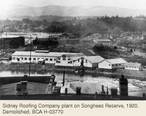
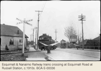
In 1895 John Tait (or Tate) built a brewery out on (Old) Esquimalt Road, now Wilson Street, where his son Fred brewed Silver Spring Old English Ale and a fine stout. In 1907 this business was sold to a former employee of the Victoria-Phoenix Brewery, Harry Maynard, and his associates John Day and Philip Crombie, who renamed it Silver Spring Brewery to match the ale. Silver Spring acquired the old Fairall Brewery on Esquimalt Road in1908 and built a modern new brewery, donating their former site for a playground for Victoria West Public School.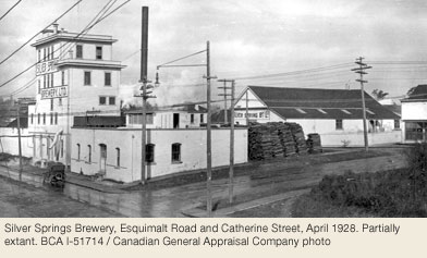
Excelsior Biscuit Bakery, located between Russell and Mary Streets, was built in 1901. It later changed hands to become Ormond Biscuit Co, the creators of high-end chocolates, crackers, and cookies. Today it is a rental storage facility, but the original signage, although faded, can still be seen on the building’s north side. Nearby was the Fairall Bottling Works, near the corner of William Street and Esquimalt Road, operated by William Fairall, producing a variety of flavoured soda waters from 1901-22. NuWay Cleaners opened its doors in the old Fairall Bottling Works building, in 1934. William’s brother Henry owned and operated the Fairall Brewery for a time.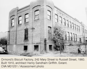
Local Businesses
Victoria West was well sprinkled with smaller establishments, and no one had to walk far for groceries, meat, drug store necessities, banking or mail. One of these was owned by Norman and Margaret Hill and was located on the corner of Front and Wilson Streets. It’s now an apartment house, but still sports a downstairs window etched with a horse and cart and the words “Hill’s Grocery.” When in full service, local residents could fill up with gas, buy meat and groceries, and pick up their coal supply. Local youngsters with bikes delivered orders. Safeway built on Springfield Street and Esquimalt Road in the early 1940s; being only a block away, Hill’s Grocery slowly became unprofitable and closed in the 1950s.
The land between Mary and Russell Streets along Esquimalt Road, now a used car dealership, was once the site of a post office and barbershop. A drug store and tailor’s shop were nearby. Vic West’s first bank at Catherine and Bay Streets, The Royal Bank of Canada, is now a doctor’s office. Just up Catherine Street was a tea and coffee shop. Victoria West’s first and only strip style mall was located on Craigflower Road, between Raynor Avenue and Pine Street. The anchor businesses were McGuire’s Drug store, Baker’s Grocery Store, Cross’s Butcher Shop, and a dry cleaner. It has been refurbished and is still home to several small businesses.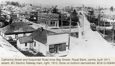
Fire hall No.4 was built in 1899 at the corner of Edward and Catherine Streets. It was an imposing brick structure topped by a bell tower, but was withdrawn from use in 1937 as the city lacked money to keep it open. The building was later renamed Salvation Army Hall and used by community groups and the scouts as a meeting place. Subsequent to that it was left to deteriorate, and once beyond repair, was demolished.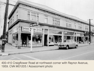
Schools & Churches
The first school in Victoria West was located above the blacksmith’s shop at Mary St and Esquimalt Road Children living in the area before that attended Craigflower School. It charged a fee and to get there required a boat trip up the Gorge. A more suitable local school was needed, and a 28’ by 48’ wood structure was built on Front St in 1888, taking in 66 students. By 1895 as more land became subdivided and Vic West’s population grew, enrollment had increased to 150. Additions were built, teachers were added and space was even rented in the Mary Street Baptist church. By 1907 enrollment had increased to 300, and architect Colonel William Ridgeway-Wilson designed a new one. It was a handsome two-storey brick building, similar in style to the recently saved Lampson Street School, and was completed in 1908. A brick annex became the Manual Training building in 1910 and in 1913 a second brick annex was built for Domestic Science on the north side of the grounds. All remained relatively unchanged until 1971 when a new school was built on the corner of Front and Langford Streets, once the site of seven houses demolished for that purpose. The original brick school was also demolished the same year. The 1910 annex, now the Kindergarten, is all that remains of the original brick structures.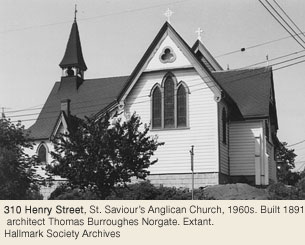
The Blacksmith’s shop that housed the first Victoria West schoolroom also accommodated the community’s first protestant congregation, who built what is now St. Saviour’s Anglican Church in 1891. In addition to St. Saviour’s, there was the Victoria West Methodist Church on Wilson Street, St. Paul’s Presbyterian on Henry Street, The Baptist Mission on Mary Street, and Saint Mary’s Catholic Church on Langford Street. When the Methodist and Presbyterian churches amalgamated, the new United Church of Canada was built on Fullerton Avenue.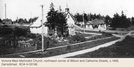
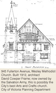
Organizations & Amenities
Entertainment was a community affair in early days and Vic West’s social centre was Semple’s Hall, at the corner of Langford and Mary Streets. Shows, concerts, plays and dances gave local residents a chance to view imported talent and to showcase their own. Although close to the fire hall, it burned in 1925 and was never rebuilt.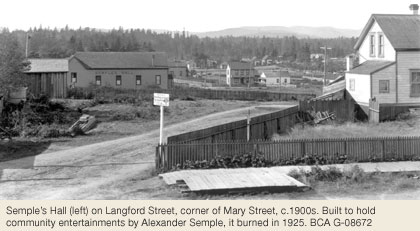
The Victoria West Athletic Association was very active up to WWII, and produced some world-class athletes. The outflow of young men to war decimated its membership, and it only rallied again in recent decades. Other recreation in Vic West was provided for the most part by Mother Nature. The inner and outer harbour and the Gorge accommodated rowing for racing and for pleasure, and the many rocky outcroppings were a natural playground for adventurous children.
The Victoria West Brotherhood was an active organization before organized government financial assistance. One of its founding members was Dr. Melbourne Raynor. He was behind the Brotherhood’s attempts to provide a healthy place for Victoria West residents, including safe areas for children to play and assistance for the area’s elderly. His entry into the political arena to further promote his causes was cut short by his accidental death in 1925. Charles Banfield took up where Raynor left off, and was especially active after he retired from his position as King’s Printer in 1946, and entered civil politics. Before he died in 1958, Victoria West had a Community Association, a “Y,” and a large park and recreation area bearing his name. A more substantial Point Ellice bridge was also on his agenda, and was completed in 1958, one year before he died at age 82.
Recent Neighbourhood Developments
Residential growth was slow after the first boom in the 1890s when upgraded bridges and the streetcar provided better access to downtown. A short flurry of activity was seen after the James Dunsmuir estate was subdivided in the 1930s. The slow growth has meant that many original homes in Victoria West still remain, although many were modernized by the application of stucco and asbestos siding. In the 1970s, as Victoria West’s population rapidly increased, industry was rerouted away from the Songhees and plans were made to replace it with high-rise condominiums and low-cost multiple dwelling housing. The Colonist, 30 May 1972, reported plans for more parks, more housing, less industry, and a general upgrading of the community, all of which has come to pass.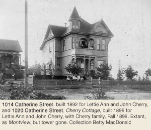
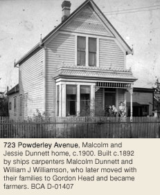
In 1984 Victoria’s first Brew Pub opened on the west side of Lime Bay in a renovated turn of the century house, originally 308 Catherine St. Initially known as the Lime Bay Inn, locals and tourists alike now know it as Spinnakers. The brewpub has two guesthouses; the one just north at 332 Catherine St has recently been restored.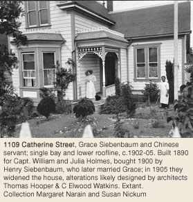
A building and restoration boom continued throughout the 1980s and ’90s, adding to Victoria West more Co-op housing, several live/work industrial-style high-rises, townhouse developments and continued heritage designation and restoration of turn of the century homes. As the Galloping Goose trail becomes incorporated into the Railyards housing development and continues along the Tyee Road corridor south to the Johnston Street Bridge, it will join up with the West Song Walkway to provide both residents and visitors with a way of enjoying Victoria West’s scenic coastline.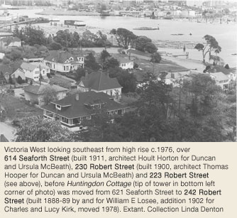
With the development of the Westside Village shopping centre and the continuing development of the Songhees lands, Victoria West can again offer its residents retail, eateries and pubs, traditional residential and multi-family housing, just as it did over a century ago.
Heritage Register Properties
65 Vic West properties on the City of Victoria's Heritage Register in 2026
Heritage-designated - Protected by bylaw. Houses eligible for VHF funding.
Heritage-registered - Not protected, may warrant future preservation. Houses ineligible for VHF funding.
Heritage covenant - Protected by legal agreement. Houses eligible for VHF funding.
NHS - National Historic Site
1317 Arm St
Designated 1989
1114 Arthur Currie Ln / 215 Raynor Av
Designated 1984
1140 Arthur Currie Ln
Designated 1984
332 Catherine St
Designated 1987
502 Catherine St
Designated 1986
715 Catherine St
Registered
917 Catherine St
Registered
923 Catherine St
Heritage Covenant
929 Catherine St
Heritage Covenant 1992
1004 Catherine St
Designated 1977
1014 Catherine St
Designated 1977
1017 Catherine St
Designated 1977
1020 Catherine St
Designated 1977
1021 Catherine St
Designated 1989
1109 Catherine St +interiors
Designated 1976
1111-1115 Catherine St
Designated 1984
1116 Catherine St
Designated 1994
1127 Catherine St
Designated 1985
1131 Catherine St
Designated 1987
1135 Catherine St
Designated 1978
1320 Coventry St
Registered
1149 Dominion Rd
Registered
322 Edward St
Registered
251-253 Esquimalt Rd (3 buildings)
Designated 1992 / NHS 1997
938 Fullerton Av
Designated 2002
310 Henry St – 2 buildings
Designated 1979 / Institutional
404 Henry St
Designated 2020
419 Henry St
Designated 2000
235 Langford St
Registered
303 Langford St
Designated 1977
420-422 Langford St
Registered
424 Langford St
Designated 2000
211 Mary St
Designated 2000
222 Mary St
Heritage Covenant 1999
303 Mary St
Registered
740 Mary St
Designated 1990
529 Northcott St
Registered
539 Northcott St
Designated 2008
543 Northcott St
Registered
631 Pine St
Registered
645-47 Pine St
Registered
723 Powderly Av
Registered
202 Raynor Av
Designated 1993
203 Raynor Av
Designated 1977
212 Raynor Av
Designated 1991
402 Raynor Av
Registered
601 Raynor Av
Registered
607 Raynor Av
Registered
206 Robert St
Registered
223 Robert St
Designated 1974 / NHS 1991
224 Robert St
Registered
230 Robert St
Designated 1980
233 Robert St
Registered
242 Robert St
Designated 1979
255 Robert St
Registered
614 Seaforth St
Designated 1977
516-18-20 Selkirk St
Designated 1999
225 Skinner St
Designated 1977
402 Skinner St
Designated 2006
505-07 Springfield St
Designated 2001
515 Springfield St
Registered
521-23 Springfield St
Registered
529 Springfield St +interiors
Designated 1999
215 Wilson St
Designated 1984
340 Wilson St
Designated 1985
350 Wilson St / 701 Mary St
Designated 1991
Chronological City History
Every city has its own unique story to tell, and Victoria is no exception. If you would like to learn more about the evolution of the thriving community we know and love today, click on the decade buttons below to reveal the events that took place during that time.
Pre-1840s
– First Nations peoples arrive in BC.
1775
– Spanish explorer Juan Francisco de la Bodega y Quadra becomes first documented European on this Island.
1778
– British explorer Capt. James Cook arrives at Nootka Island on NW coast of this Island.
1788
– British fur trader John Meares (not HBC) brings Chinese labourers to build Island’s first trading post at Nootka.
1792
– British explorer Capt. George Vancouver is first to circumnavigate what is later named Vancouver’s Island.
1835
– Coal discovered on Vancouver’s Island.
1837
– Capt. Wm Henry McNeill & SS Beaver sent by Hudson’s Bay Company (HBC) from Fort Vancouver, Washington State to Vancouver’s Island to explore area that is now Victoria, Esquimalt, Sooke.
1840s
– James Douglas surveys area for Fort Victoria – First Nation villages at Cadboro Bay & Esquimalt.
1843
– Fort Victoria, named for young British Queen, is established by James Douglas for HBC; Charles Ross supervises construction of 330 ft by 300 ft enclosure within boundaries of present Government, Wharf, Broughton & Bastion Sts.
– First Nations moved from Cadboro Bay to set up camp below the fort to work in helping build the fort.
1844
– At request of HBC, Songhees relocate village across harbour from Fort, along E & S shore of Victoria West.
1846
– Oregon Treaty between United States & Great Britain is signed; Britain relinquishes claims to territory S of 49th parallel, but keeps southern portion of Vancouver’s Island (49th parallel runs through Ladysmith).
1848
– Measles & influenza epidemics hit Victoria.
1849
– Vancouver’s Island becomes “British Colony of Vancouver’s Island” with the capital at Victoria.
1850s
– HBC discovers coal at Nanaimo.
– Songhees Indian Reserve established by treaty by James Douglas.
1851
– Robt Dunsmuir arrives from Scotland as an HBC indentured coal miner; eldest son, James, born on shipboard.
– John Work establishes Hillside Farm.
1852
– J.D. Pemberton surveys Victoria townsite, first streets laid out – bounded on W by harbour, E by what is now Government St, S by Fort St, N by Johnson St.
1853
– Gov. James Douglas sets aside 10 acres as School Reserve in what is now Fernwood.
– Puget Sound Agricultural Co establishes Craigflower Farm; Craigflower School opens (2755 Admirals Rd, Saanich).
1854
– Crimean War – British Royal Navy ships come to Fort Victoria, hospital is erected in Esquimalt.
– First census in Victoria – there are 282 “Whites,” & approximately 2,000 “Indians” or First Nations from Saanich Peninsula to Sooke Basin.- first bridge built across Victoria harbour.
1855
– Isabella Ross (1490 Fairfield Rd, Fairfield), widow of HBC employee Charles Ross, becomes Colony’s first female landowner when she buys 99 acres of land from HBC.
1856
– HBC allows settlers to buy land on instalment plan.
– First election for House of Assembly.
– First District Church (Anglican) consecrated.
1858
– April 25 – First miners arrive via steamer from San Francisco for Fraser River goldrush. Victoria experiences growth spurt: in 6 weeks, 225 buildings are erected; price of harbour-front lots in Esquimalt & Victoria rises from $5 to over $1,000.
– First Chinese arrive from San Francisco.
– Gov. James Douglas welcomes 700 African-American families from San Francisco to Victoria.
– First Sisters of St. Ann arrive in Victoria.
– St. Ann’s Schoolhouse (637 Elliot St, James Bay) opens with 35 pupils.
– Mainland territory of New Caledonia becomes Crown Colony of British Columbia (BC), Gov. James Douglas, who is also governor of the Colony of Vancouver Island.
– Victoria Gazette & British Colonist first published.
– First brick building, Victoria Hotel, later known as Windsor Hotel (901-905 Government St, Downtown).
– Waddington Alley is first street paved in wood blocks.
– Baron Lowenberg establishes possibly first real estate business – Lowenberg, Harris & Co.
– Beacon Hill Park established by HBC.
1859
– Queen Victoria cancels HBC’s Crown grant.
– Victoria Philharmonic Society is founded.
– St. Andrew’s Society is founded.
– May 2 – Victoria’s first horse race in Beacon Hill Park.
– Victoria’s shipbuilding industry begins at Laing’s Way, at foot of Dallas Rd at Erie St.
– Royal Victoria Hospital opens on Songhees Reserve to treat both Songhees & non-aboriginals.
1860s
1860
– Colonial Government buildings, designed by H.O. Tiedemann & nicknamed the Birdcages because of their similarity to Chinese pagodas, open on S side of Inner Harbour (501 Belleville St, James Bay).
– Charles G. Wylly (431 Young St,), acting in his capacity as average adjuster, makes 1st property assessment for taxation for Colonial Government.
– March – first Victoria directory published by architect Edward Mallandaine (560 Simcoe St,).
– Japanese goods first appear in Victoria shops.
– Gov. James Douglas declares Victoria a free port.
– Victoria Gas Co is formed.
– First Nations mission school opens on the Songhees reserve at request of the Songhees
– August 20 – Victoria Masonic Lodge No. 1085 is founded.
– B.W. Pearse builds Fernwood, Colony’s first stone house.
– December – NE bastion of Fort Victoria is demolished.
1861
– New Post Office established on Wharf St.
– Residential development east to Cook St.
– First Point Ellice Bridge built.
– Rock Bay Bridge built.
– 608 permanent residents; 25,000 miners pass through on way to mainland gold fields.
– Sir Joseph Trutch’s home built, Fairfield at 601 Trutch St, Fairfield.
1862
– Gold rush to Barkerville & Cariboo begins.
– Victoria has 446 voters, elects 2 to colonial govt.
– Govt bill forbids construction of wooden buildings over 18 feet high or more than one storey within town due to fire risk.
– Original Johnson St Bridge removed.
– March – Smallpox epidemic hits Victoria, carried by miner from San Francisco; kills 14,000 First Nations along coast from Vancouver to Alaska; Gov. Douglas has all Songhees in Victoria vaccinated & none die here, although other Victoria citizens died; smallpox runs in Victoria until February 1863.
– May 16 – Colonial govt passes “An Act to Incorporate the City of Victoria.”
– August 2: City of Victoria is incorporated; 18th: first civic election, Mayor Thomas Harris elected; 25th: first City Council meeting.
– First City bylaws included: wooden buildings over one storey forbidden downtown; speed limit set at 8 mph; evil-smelling slaughterhouses & tanneries banned within city limits; illegal to throw rubbish & offal into harbour; beating carpets prohibited after 8 am.*
– Business district lit with gas. – City boundary moves east to Douglas St.
– October 24 – First library established in Victoria by H. Heisterman, with 160 members.
– November – HMS Hecate surveys Vancouver Island.
1863
– February – Victoria carpenters establish BC’s first trade union, Journeymen Shipwrights Assoc of Victoria & Vancouver Is.
– City Council awards contract for street construction.
– First “free” school in Colony opens in Esquimalt.
– April 9 – Cornerstone laid for 1st Presbyterian Church.
-Albion Iron Works founded at Chatham & Discovery Sts.
– June 2 – Foundation laid of Congregation Emanu-el Synagogue, architects John Wright & George H. Sanders (1421 Blanshard St, Downtown); now the oldest synagogue in Canada.
– Dollar replaces British pound as currency of Colony of Vancouver Island.
– Summer – First use of street numbers for businesses.
– James Douglas retires as Governor of both colonies.
– New residential suburbs develop N of Pandora St.
– Richard & Emily Carr build home at 207 Government St, James Bay.
– Lush family buys land from Carrs, builds Park Hotel, later Colonist Hotel, with its noisy saloon.
1864
– Telegraph system introduced to Victoria.
– November – HBC demolishes last of Fort Victoria stockade & bastions; subdivides land.
– Spring Ridge Water Works Co, formed by Coe & Martin, serves city until 1875.
– Leech River gold rush near Sooke.
– Ladies committee buys land for hospital at Pandora & Chambers Sts.
– Western Canada’s first Odd Fellows Lodge formed in Victoria, sponsored by California Grand Lodge.
– Caledonian Benevolent Society (now St. Andrew’s & Caledonian Society of Victoria) organizes first Highland Games in Victoria, still held today.
– Mechanics Literary Institute reading room opens.
– Diphtheria epidemic in Victoria.
1865
– Governor Kennedy buys Cary Castle for $19,000 (1401 Rockland Av, Rockland).
– Formal recognition of Esquimalt as Royal Navy shore establishment, chief British Naval Station on W coast.
– August – First public school opens on School Reserve.
– Georgina Kennedy lays foundation stone for Angela College (923 Burdett St, Fairfield).
– Ross Bay Villa (1490 Fairfield Rd, Fairfield) built for Charles Buxton & leased to Frank Roscoe.
– Black measles epidemic kills many residents, especially children.
1866
– City’s first water pipes laid – Spring Ridge Water Co.
– Transatlantic telegraph cable laid from England & San Francisco to Victoria.
– November 19 – Vancouver Island & BC united as Crown Colony of BC- mainland New Westminster becomes capital.
1867 – July 1 – Confederation of Canada: Ontario, Quebec, Nova Scotia, New Brunswick are first four provinces.
– Colonist comes out in support of women’s suffrage.
– Municipal franchise extended to all property owners.
– Victoria Council’s 1st Black member – Mifflin Gibbs (see 503 Superior St).
1868
– Victoria becomes capital city of BC.
– First Victoria city directory second edition is published.
– Defences built against attacks by Americans.
– Saanich Fall Fair begun.
1869
– New James Bay Bridge opens.
– First “velocipedes” (early bicycles) in Victoria; Colonist orders six for delivery boys.
– Robert Dunsmuir, with HBC’s “Free Miners Licence,” discovers coal seam near Departure Bay, Nanaimo; claims 1000 acres & begins to develop Wellington Coal.
1870s
1870
– Douglas St is gravelled from St. John’s Church south.
– Gas introduced into houses, public lamps, barracks & jail.
1871
– July 19 – BC enters Confederation as province of Dominion of Canada.
– Canada Census – Victoria’s population is now 3,270.
– Cornerstone laid for new St. Ann’s Academy, architect Charles Vereydhen (835 Humbolt St, Fairfield).
– Artist Emily Carr born at 207 Government St, James Bay.
– Sir Joseph Trutch appointed BC’s first Lieutenant-Governor (Lt-Gov) (601 Trutch St, Fairfield; 1401 Rockland Av, Rockland).
1872
– Opening of first Provincial Legislative Assembly; passes bill giving more rights to married women.
– New Christ Church Cathedral built.
– Driard Hotel opens with fireplace in each room.
– City buys land at Ross Bay for new cemetery, Ross Bay Cemetery, Fairfield.
– Ship arrives with passengers infected with smallpox, pest-house opens on Dallas Rd, child Bertha Whitney dies & is buried there.
– November 5 – Victoria’s last public hanging – George W. Bell, convicted murderer of Thomas Datson.
– City boundaries expanded.
1873
– Victoria City Council lowers speed limit to 6 mph, & divides downtown into areas to use as stands for horse-drawn hacks for cargo & express wagons for passengers.
– Foundation stone laid for dam at south end of Beaver Lake, to make Elk Lake the City’s major source of water.
– Driard Hotel has water piped in from local wells.
– Marine Hospital built on Songhees land in Vic West.
– Protestant Orphan Asylum Society established by several prominent women including Mary Cridge.
1874
-Jacob Sehl installs elevator in Government St store.
– Christ Church Cathedral congregation splits between Bishop Hills & Dean Edward Cridge; Cridge & followers march down hill & found Church of Our Lord (626 Blanshard St, Downtown).
– Future BC Premier Theodore Davie marries 14-year-old Blanche Baker, who dies two years later.
1875
– City Council decrees they will employ no Chinese.
– Three women cast votes in Victoria civic election.
– Custom House, Victoria’s oldest Federal Building, opens; architects T.S. Scott & Fed Dept Public Works (1002 Wharf St, Downtown).
– Dr. Simon Fraser Tolmie proposes to BC Legislature that women should have vote – defeated.
– City begins pumping water from Elk Lake; Spring Ridge Water Works Co is dissolved.
– November 4 – SS Pacific founders off Cape Flattery, loss of 275 lives, many from Victoria.
1876
– January 16 – first service in Church of Our Lord, architect John Teague (626 Blanshard St, Downtown), Reformed Episcopal Church led by Bishop Cridge, who builds his James Bay home Marifield that same year.
– St. Joseph’s Hospital opens (850 Humboldt St, Fairfield).
– Victoria’s first high school opens.
– Economic downturn, Douglas lends province $30,000.
1877
– Sir James Douglas dies.
– First “self-acting water-closets” installed in Victoria.
– BC government declares first Thanksgiving Day.
– First roller skating rink opens in Victoria.
1878
– R.B. McMicking & Bell Telephone Co install first two telephones in Victoria, in Colonist & CPR offices.
– Volunteer militia established here.
– BC govt attempts to tax all Chinese in province $60. Chinese go on strike, law declared unconstitutional.
– December 11 – First Council meeting in new City Hall, architect John Teague (#1 Centennial Sq, Downtown).
1879
– January 8 – 1 metre (39”) of snow covers City.
– April – Union Club forms, Judge Matthew Begbie first president.
1880s
1880
– January 11 – 81 cm (32”) snow covers city; 700 sheep reportedly found sleeping under snow at Macaulay Point.
– January 21 – General telephone service established.
– Victoria property assessments total $2.4 million.
1881
– Year opens with 60 cm (24”) of snow.
– Canada Census – Victoria’s population is now 5,925 & city has 56 saloons.
– R.B. McMicking offers to light City from nine 60 foot towers for $490 per month.
– Telephone office opens all night, now 100 subscribers.
– McMicking sets up eight telephone fire alarm boxes.
– BC govt transfers Beacon Hill Pk (James Bay/Fairfield) to City of Victoria.
1882
– September 20 – Arch erected on Fort St for the visit of the Marquess of Lorne & Princess Louise.
1883
– August 20 – Robert Dunsmuir signs with federal govt to build Esquimalt & Nanaimo Railway (E&N) for subsidy of $750,000, & land grant of 2,000,000 acres (1/5 Vancouver Is), including all coal under & all timber on top.
– July – Victoria carpenters establish 1st union local, United Brotherhood of Carpenters & Joiners.
– December – First electric street lighting in City.
1884
– Head tax of $50 imposed on Chinese immigrants.
– January – Kingston Street School, aka James Bay Ward School, opens at Kingston & Oswego Sts, later 326 Kingston St.
– June – City takes over electric light plant.
– July – First house numbers listed in city directory.
1885
– Victoria School District has 732 pupils & 17 teachers.
– Tenders are called for new jail.
– St. James Anglican Church, later 307 Quebec St (pg 47), is dedicated.
– Outer Wharves or Piers in Major Bay near Shoal Point, James Bay, built by Robert P. Rithet to serve his world-wide sugar interests; they later become valuable docking point for passenger liners.
– Joseph Heywood installs fountain & horse trough at intersection of Hillside, Government & Douglas Sts & Gorge Rd.
– November – Last spike of transcontinental railroad is driven; first freight from Eastern Canada arrives in Vancouver.
1886
– Local census: 8,452 Whites, 2,978 Chinese, 101 First Nations.
– Dr. George Milne (617 Battery St, James Bay) appointed first City Health Officer.
– David Spencer opens dry goods store The Arcade.
– Victoria Electric Illumination Co incorporates.
– City of Vancouver is incorporated.
– August 14 – PM Sir John A. MacDonald drives last spike for E&N at Shawnigan Lake; first train travels between Nanaimo & Victoria West.
– BC Provicial Museum (now Royal BC Museum) is established in a room in government Birdcages, 501 Belleville St, James Bay.
1887
– Vancouver, not Victoria as anticipated, becomes terminus of Canadian Pacific Railway (CPR).
– July 20 – official opening of first Graving Dock in Esquimalt; one of the Terms of Union by which British Columbia joined confederation.
– Caledonian Park established on block between Government, St. Andrews, Niagara & Simcoe Sts; annual Highland Games & other sporting events are held here until land sold for development in 1907.
– Work Point site becomes permanent barracks for Canadian Army.
– Celebrations of Queen Victoria’s Golden Jubilee.
– Standard time is adopted in Victoria.
– Lights turned on at Canada’s first incandescent electric light station, here in Victoria.
– Joseph Despard Pemberton establishes real estate firm of Pemberton & Son, now called Pemberton Holmes.
1888
– 76 cm (30”) of snow covers city.
– First railway swing bridge built across harbour to Store St; footbridge built.
– March 29 – first E&N train to downtown Victoria.
– National Electric Tramway & Lighting Co (NET&L) signs agreement with City to operate streetcars.
– First public lavatory erected in Bastion Sq, men only.
– Letter carriers & letter boxes first appear.
– Survey begun for Victoria to Sidney railway (V&S).
– Diphtheria epidemic in Victoria.
1889
– Foundations laid for Royal Jubilee Hospital at Richmond Rd & Fort St to mark Queen’s Golden Jubilee.
– City has 79 street lamps, 315 telephones.
– New Provincial Court House, architect H.O. Tiedeman (28-30 Bastion Sq, Downtown).
1890s
1890
– February – Electric streetcar service – 3rd system in Canada.
– Sewer system installed.
– City boundaries expanded to include Victoria West.
– Corrig College, boys’ private school, opens at 46 Douglas St (ex-220 K(C)atherine St) at Niagara St (see pg 31).
– Fairfield neighourhood included in City’s boundaries.
– Royal Jubilee Hospital (1900 Fort St, Jubilee) opens.
– January – St. Andrew’s Presbyterian Church, architect Leonard Buttress Trimen, opens (924 Douglas St, Downtown).
– Victoria property assessments total $9.4 million, while Vancouver’s are $9.5 million.
1890
– Chinese tenements raided under City’s cubic air space bylaw: it allows tenants no less than 384 cubic feet.
1891
– Canada Census – Victoria population of 16,841 is served by 55 hotels & taverns.
– Victoria property assessments almost double to 17.6 million.
– May 5 – Mayor Grant starts City Hall’s McKillican Clock.
– May 12 – HBC sells at auction a number of lots from original Fort Victoria property.
– Transit system extended to Oak Bay.
– Capt. John Irving (256 Menzies St, pg 15) starts daily ferry service Victoria to New Westminster.
– James Bay Athletic Association clubhouse, built for $7,000, opens at foot of Menzies St.
– Public Market opens on Cormorant St downtown.
– First pneumatic tire bicycle in BC owned by C.T.W. Piper.
1892 – April 18 – Local smallpox epidemic, Port of Victoria shut for six months, local economic depression begins.
– City starts permit systems for water & sewer hook-ups.
– New NET&L Powerhouse begins generating steam, architect John Teague (2110 Store St, Downtown).
– James Bay Methodist Church (now United Church), architect Thomas Hooper, dedicated (511 Michigan St, James Bay).
– St. Andrew’s Roman Catholic Cathedral opens, architects Perrault & Messiard (1202 Blanshard St, Downtown).
1893
– 1.7 m (67”) of snow covers city.
– World trade depression, & city hires unemployed to work on local improvements at $2.00 for a 10-hour day.
– Council allocates $1,000 for signposts & street names.
– Thomas Plimley & Albert Onions open Victoria’s first bicycle shop at 42 Broad St.
– Postmen start using bicycles.
– Arion Male Voice Choir founded as Arion Club of Vict.
– Esquimalt Marine Railway Co Ltd is established in Esquimalt by William F. Bullen (1007 Joan Cr, Rockland) & partners.
– Contracting firm Moore & Whittington is established.
– November 29 – Victoria Chemical Co (VCC) incorporates with works at 7 Dallas Rd at Erie St, manufacturing acids, fertilizers & tree sprays.
1894
– Sehl House at 1 Montreal St on Laurel Point destroyed by fire.
– NET&L in receivership, is re-incorporated as Victoria Electric Railway & Lighting Co.
– South Park School, architect William Ridgway-Wilson, 508 Douglas St, James Bay, opens.
1895
– Daily Colonist notes first “motor carriages.”
1896
– 73 cm (29”) of snow covers City.
– May 26 – Point Ellice Bridge collapses into Upper Harbour under weight of loaded streetcar; 55 people die.
1897
– First Chinese public school in Canada opens in Victoria.
– Fort St is paved with wooden paving blocks.
– Typhoid fever epidemic in Victoria.
– Consolidated Railway Act joins Victoria & Lower Mainland gas & electric companies to become BC Electric Railway (BCER).
– West Coast’s first hydroelectric generating plant built at Goldstream to service Victoria.
– Lady Aberdeen, wife of Canada’s Gov-Gen, establishes Victorian Order of Nurses for home health care.
1898
– Chinese in Canada disenfranchised.
– February – BC’s Parliament Bldgs open (501 Belleville St, James Bay).
1899
– 80 cm (31.5”) of snow covers City.
– City opens No. 2 Fire Hall in Fernwood
– October 11 – Boer War begins; ends 31 May 1902.
1900s
– January 22 – Queen Victoria dies; Edward VII is now King.
– Telephone service extended to Duncan & Nanaimo.
– Canada Census: Vancouver’s 26,196 population passes Victoria’s 20,919.
– City Council passed James Bay Mud Flats Reclamation By-law, No. 372.
– October – Visit of Their Royal Highnesses The Duke & Duchess Of Cornwall & York – Bastion arch erected on corner of Government & Belleville Sts.
1902
– Andrew Carnegie gives $50,000 for new library bldg; the lot cost $7,400 (794 Yates St, Downtown).
– May 23 – First gas‑powered automobile arrives in city for Dr Edward C. Hart, an Oldsmobile costing $900.
– First motorcycle appears in Victoria.
– Mount Baker Hotel in Oak Bay destroyed by fire.
1903
– City’s first water meters installed.
– April – first Tally Hos run by Victoria Transfer Co.
– First steam-driven automobile bought by Bert Todd (721 Linden Av, Rockland).
– Inner Harbour Causeway over James Bay mud flats is begun, foreman from October, Thomas Donovan (1459 Vining St, Fernwood).
1904
– BC motor vehicle licence plates now compulsory.
– December – First telephone call from Victoria to Vancouver.
– BCER begins selling gas appliances for the home.
1905
– May 1 – CPR buys E&N from James Dunsmuir.
– Automobile Club formed by owners of approximately 20 cars & 10 motorcycles.
– Hutchinson Bros first automobile livery (taxi service).
– BCER opens Gorge Amusement Park.
1906
– Saanich & Oak Bay incorporated as municipalities.
– BCER hires first female employee.
– January 23 – Property for Central Park, called North Park, purchased from Finlayson Estate for $21,000.
– 1852 James Douglas home on Government St demo’d.
– Many more concrete sidewalks built in City under Local Improvement Bylaw No. 477.
– Bill & Walter Luney establish Luney Construction.
1907
– Victoria buildings renumbered, street names changed.
– City Assessor William Walter Northcott becomes City Building Inspector & sets up modern system of building permits & plans in August.
– Great building boom begins – 349 new structures built.
– Takata Japanese Tea Gardens open on the Gorge.
– When two plague-carrying rats discovered in Seattle, Victoria City Council orders Chinatown improvements: 200 sewer connections, wood shanties demolished, wooden boardwalks replaced with concrete.*
– July 23 – Fire destroys Chinatown from Chatham & Herald Sts, Store St to Government St, to Quadra St between Green & North Park Sts.
– Parfitt Brothers establish contracting firm (1301-11 Gladstone Av, Fernwood).
1908
– Ottawa enacts legislation to stop opium manufacture & sale – 6 Victoria firms close.
– Smith’s Hill Reservoir, construction begins, completed in 1909; foreman Thomas Donovan (1459 Vining St, Fernwood).
– Opening of CPR’s Empress Hotel, architect F.M. Rattenbury (721 Government St, Downtown).
1909
– Cook St streetcar line begins service.
– August 7 – Opening of Chinese Public School, architect D.C. Frame (636 Fisgard St, Downtown).
– Victoria Steam Bakery at 126 Niagara St destroyed by fire; built by Moses Rowe Smith in 1888 & run by Selena Smith & their sons following his death.
1910s
1910
– May – The Naval Service of Canada is created; renamed Royal Canadian Navy by King George V in 1911.
– Mayor A.J. Morley plans cluster lights in downtown.
– May 27 – BC government auctions 15 frame houses, 13 on Superior St & 2 on Government St, for construction of rear wings & library of Parliament Buildings.
– September 24 – William Wallace Gibson flies home-built plane for 200 feet above Lansdowne field; first flight in Western Canada by a Canadian of a Canadian-built plane (146 Clarence St, James Bay).
– October – Downtown fire destroys Spencer’s & Five Sisters Block, etc; City extends View St to Government St.
– Victoria’s building permits for year total $2,373,045.
1911
– 4200 telephones now in City.
– Songhee Band agree to compensation for giving up reserve lands in Vic West, after 30 years of negotiations, & move to new reserve on Esquimalt harbour; each family receives $10,000, there are 43 families, total 93 people.
– Lester & Frank Patrick build artificial ice rink.
– Carpenters paid $4.50 per day.
– Road to Mill Bay passable, christened Malahat Drive.
– City contracts to pave 30 miles of streets.
– Opening of Alexandra Club for Ladies, architect D.C. Frame (716 Courtney St, Downtown).
– April – First auto show is held.
– May 10 – Luneys incorporate as Luney Bros Ltd.
– Jordan River hydroelectric plant begins service to Victoria.
– Clearing begins on Uplands area in Oak Bay.
– Victoria’s building permits for year total $4,026,315. – Quarter acre lots between Cook & Quadra Sts sell for $500-$800.
– Canada Census – Victoria’s population is now 31,660; Vancouver’s Chinatown population surpasses Victoria’s.
– City begins to build seawall to stop graves from washing out to sea at Ross Bay Cemetery; Dallas Rd continues E.
– Diphtheria epidemic in Victoria.
– December 25 – Frank & Lester Patrick open the 4,000-seat Victoria Arena in Oak Bay, designed by Thomas Hooper & built for $110,000; it & its sister arena in Vancouver had first artificial ice in Canada.
1912
– Victoria Police buy motor patrol wagon.
– Esquimalt incorporates as the Corporation of the Township of the Municipality of Esquimalt.
– September – Visit of Governor General Prince Arthur, Duke of Connaught & Strathern, and Princessa Louise; Duke lays cornerstones for Connaught Seaman’s Institute, architect J.C.M. Keith (106 Superior St, James Bay) & Provincial Library, architect F.M. Rattenbury (501 Belleville St, James Bay).
– VCC amalgamates with other companies, including Giant Powder Works as Canadian Explosives Co & moves operations to James Island out of Sidney, BC.
– September – Coal mines shut; Vancouver Island’s “Big Strike” begins.
– September 3 – 88th Regiment Victoria Fusiliers is formed in Victoria.
– December – St John’s Iron Church demolished downtown.
– Victoria’s building permits for year total $8,060,170; registration fees at Land Registry Office reach $5,800; drops to $300 by 1917 because of WWI.
1913
– April – BC liquor law restricts opening days & hours.
– Victoria Fire Department (VFD) is motorized.
– BC Electric Railway (BCER) begins service to N Saanich
– Work begins on Saanich to Patricia Bay railway
– Victoria’s first skyscraper opens, BC Permanent Loan Co, 10 storeys, 1403 Douglas St, arch’t H.S. Griffiths, (demo’d).
– Province‑wide depression starts, real estate collapses.
– End of Victoria’s building boom; building permits for year total less than $4 million.
– new Union Club of BC opens, architect Loring P. Rixford (805 Gordon St, Downtown).
– July & August – Miners’ strike riots in Cumberland, South Wellington, Ladysmith, Extension & Nanaimo.
– August 15 – 50th Regiment (Gordon Highlanders) is authorized with first CO Lieut. Col. Arthur Currie (1114 Arthur Currie Ln, Vic West) .
– August – Canada’s first fatal air crash, during Victoria Summer Carnival – American barnstormer John Bryant crashes his Curtiss seaplane onto roof in Chinatown.
– December 29 – Opening of Royal Theatre, architects Wm. D’Oyly Rochfort & Eben W. Sankey (805 Broughton St, Fairfield).
1914
– January – 60 wives & mothers of Vancouver Island miners plead with BC Premier Richard McBride for release of jailed 1913 strike rioters.
– British shipbuilder Sir Alfred Yarrow buys BC Marine Railway Co from Bullens, renames it Yarrows, & leaves his son Norman Yarrow in charge.
– Sanatorium for BC built at Tranquille, near Kamloops.
– Beacon Hill School opens, architect J.C.M. Keith (120 Douglas St, James Bay).
– New Victoria Police Station opens, architect J.C.M. Keith (625 Fisgard St, Downtown).
– Victoria hires first police woman.
– 4th Victoria High School, architect C. Elwood Watkins (1260 Grant St, Fernwood).
– Pantages Theatre, architect Jesse M. Warren, opens (#3 Centennial Sq, Downtown), now McPherson Playhouse.
– August 4 – Britain declares war on Germany; as a member of British Empire, Canada too is at war – WWI.
– August 15 – Panama Canal opens, improving access for European settlers & goods to Victoria & West Coast.
– August 20 – Miners accept colliery terms; end of Big Strike.
– Gonzales Observatory (302 Denison Rd, Gonzales) opens, headquarters of Dominion Meteorological Services.
– Construction begins on Ogden Point Breakwater & Docks, James Bay.
– November 12 – two women officers are sworn as first female members of Victoria Police Force, Mrs Jane Clayards & Miss Mary Cameron McDonald, RN, a 1900 Royal Jubilee grad.
1915
– RMS Lusitania sunk by Germany, Anti‑German riots break out, many businesses damaged & looted.
– Jitneys (independent taxis) compete with BCER.
– BCER streetcar fares raised a penny to 6 cents.
– BC Parliament Building (501 Belleville St, James Bay) additions completed, mainly library at rear, architect F.M. Rattenbury.
– November – BC Returned Soldiers’ Aid Commission is established.
1916
– February – Snowfall paralyzes city ‑ army helps clear downtown; estimate of 1.5 million tons – 183 cm or 72”!
– BC Shipping Act passes: Victoria’s shipbuilding industry produces five 2,500-ton & twenty 3,000-ton wooden steamers during WWI for Imperial Munitions Board.
– Provincial referendum approves prohibition of alcohol & gives women the right to vote.
– old centre block of Houses of Parliament in Ottawa is destroyed by fire; the library survives the blaze.
1917
– January 1 – BC Compension Act passed: collieries, logging companies, etc., must provide widows’ pensions.
– January 22 – last of about 10,000 granite blocks is placed on Ogden Point Breakwater, James Bay.
– Caucasian women register to vote in provincial election.
– Federal govt establishes “temporary income tax”.
– September – Feds pass Soldier Settlement Act.
– October 1 – Prohibition of alcohol in BC begins.
– “Workman’s Compensation Board” established.
– December 6 – Halifax Explosion: about 2,000 killed, 9,000 injured, over 12,000 buildings in 16 mile radius destroyed or damaged; most devastating man-made, non-nuclear explosion in history.
1918
– Canada Registration Board established to create inventory of men & women over 16 who could be recruited for military service or essential wartime industry.
– Two piers & a cargo warehouse completed at Ogden Point, total cost, with breakwater, of $5 million.
– Dominion Astrophysical Observatory opens on Little Saanich Mountain (5071 West Saanich Rd, Saanich); largest telescope of its kind in the world at the time.
– All Caucasian women given the right to vote federally.
– October 26 – CP Steamship SS Princess Sophia, sailing inside passage from Victoria to Alaska, sinks with all 343 on board; worst shipwreck in BC & Alaska history.
– October & November – Spanish Influenza epidemic forces closure of public places; kills more people worldwide than WWI.
– November 11 – Armistice is signed & fighting ceases.
– Vic High – 3 teachers, 53 former students died in WWI.
– December 7 – 7.8 magnitude earthquake off West Coast of Vancouver Island.
1919
– HRH Edward, Prince of Wales, visits Victoria.
– February 10, 11 – 169 teachers of Victoria & District Teachers Association hold 1st teachers strike in Canada.
– June 28 – Treaty of Versailles signed, official end of WWI.
– November – Victoria’s General Sir Arthur Currie, GCMB, KCB, (1114 Arthur Currie Ln, Vic West), Commander-in-Chief of Canadian Forces at end of WWI, comes to sell Victory Loans.
– U.S. International Airmail Service begin operating float planes between Victoria, Vancouver & Seattle, using beach landing at Shoal Point, James Bay, between Brackman & Ker & Victoria Chemical Co wharves.
1920s
1920
– June – James Dunsmuir dies.
– Women vote for first time in provincial election.
– Sidney Roofing & Paper Co opens on Songhees industrial reserve, Vic West, south of E&N bridge.
– Pemberton Holmes sells just 65 properties.
1921
– June 15 – Prohibition ends in BC.
– Victoria Real Estate Board (VREB) is established; during 1920s, it promotes improvements such as highway from Jordan River to Port Renfrew; urges government to acquire & protect area now known as Cathedral Grove along Alberni Highway.
– BC Government Liquor Act comes into effect; nine govt liquor stores open across province.
– New fire insurance plans (FIP) drawn up for Victoria.
– 54 Soldiers’ Settlement houses are built in Victoria for returned soldiers with funds obtained through National Better Housing Act.
– Canada Census – Victoria’s population is now 38,727.
1922
– January 1 – Rule of the Road change: Vancouver Island vehicles switch to right side of road like rest of province.
– October 2 – Johnson Street Bridge vehicular span opens.
– BC govt bans Orientals from pulp & paper mills.
– St James Anglican Church in James Bay demolished.
1923
– Chinese Immigration “Exclusion” Act prohibits Chinese from underground work, excludes all Chinese except consuls, merchants & students from entering Canada; only 15 enter Canada between 1923 & 1946.
– November 30 – first burial in Victoria & Saanich’s new inter-municipal cemetery, Royal Oak Burial Park.
1924
– Johnson St Bridge, later known as “Blue Bridge,” opens.
– Interurban railway from Victoria to Saanich is closed.
– Six Harbours Agreement between BC & Canada is established: Victoria is one of six harbours defined as a federal “public harbour” by Transport Canada.Canada Hockey League champions, defeat Montreal Canadiens, National Hockey League (NHL) champions 3 games to 1, games 1, 3 & 4 played in Victoria Arena on Cadboro Bay Rd, Oak Bay, Lester Patrick, manager.
– June 21 – Victoria is visited by Royal Navy’s special service squadron on goodwill tour around world; special dance for locals is held on board HMS Hood.
– new CPR Terminal & Ticket Office opens in Inner Harbour, architects F.M. Rattenbury & P.L. James (470 Belleville St, James Bay).
– Old Colonist Hotel at 200 Douglas St is demolished.
1925
– Presbyterian, Methodist & Congregational Churches amalgamate as The United Church of Canada.
– The Crystal Gardens, architects F.M. Rattenbury & P.L. James, opens with largest salt water pool in British Empire, & two dance floors (701-711 Douglas St, Downtown).
– New construction in Victoria valued at $500,000.
– Panama Pacific Grain Terminals Elevator Co Ltd with City of Victoria builds grain terminal on Pier North B, James Bay, to load prairie grain arriving by rail onto deep-sea freighters for shipment around world.
Stanley Cup comes to Victoria – Victoria Cougars, Western
1926
– October 26 – Mail plane flying from Lansdowne Field to Seattle crashes into Sen. Robert Green’s house, 502 Rupert St.
– Land assessments in Victoria total $6.1 million.
1927
– July 1 – Canada’s Diamond Jubilee (60th) celebrations.
– July 1 – New Esquimalt Graving Dock opens, third largest in World.
– Old Age Pension Act, Canada’s first public pension plan, passes – criteria: any British subject in Canada, 70 or older; resident in Canada 20 years; income less than $365 a year.
– Victoria’s first zoning bylaw implemented, to be “the final means of perpetuating town planning principles in the city” VDC 26 November 1927.
– BCER installs electric heaters on streetcars.
– BCER creates Victoria’s Home Service division to promote use of home appliances.
– Clover Point rifle range, built during WWI, made city park.
– Smallpox epidemic in Victoria.
– Thomas Plimley opens used car showroom at 1010 Yates St, building still extant.
1928
– BC’s first all-electric home opens at Linden & Oscar Sts in Fairfield; 15,000 people attend open-house week.
– Old City Jail at rear of City Hall is demolished.
1929
– January – BC Power Corporation is incorporated.
– January 28 – BC Airways “airdrome” opens on Shelbourne St.
– BC Water Act creates Provincial Water Board.
– BC govt builds concrete Benvenuto Av, W Saanich Rd to Butchart Gardens, Vancouver Island’s main tourist attraction.
– September 28 – Christ Church Cathedral, architect J.C.M. Keith, (908-912 Vancouver St, Fairfield, ) is consecrated, building finished in 1950s & 90s.
– October 18 – British Privy Council declares Canadian women Persons – Victory for The Famous Five, including Nellie McClung, Saanich resident 1935 until death in 1951.
– October 29 – New York Stock Market crashes; Great Depression begins.
– November 11 – Victoria Arena destroyed by fire.
– December – Dallas Hotel, built 1891, demolished.
1930s
1930
– During Great Depression, Victoria offers residential lots for $50 each if new owners will immediately build houses on then; Canadian govt will finance 80% of value.*
1931
– Canadian Government outlaws Communist Party.
– Sperry Beacon tower built on Inner Harbour, in preparation for seaplane terminal, which didn’t materialize, due to Depression; architects Townley & Matheson (812 Wharf St, Downtown).
– Canada Census – Victoria now 39,082.
1932
– City of Victoria pays $374,621 relief to unemployed.
– Elsie Richards becomes first female member of VREB.
1934
– BC govt cancels annual sale on lands in tax arrears; farmers can work off one-year’s arrears on public works.
– August – MacDonald Park established on portion of former Armadale land – 241 Niagara St.
– Smallpox outbreak.
1935
– Federal govt’s Dominion Housing Act lends funds for housing through financial institutions & other govts; creates Economic Council of Canada to advise on housing conditions.
– January 21 – three-day rainfall begins, 5.9” floods city.
1936
– Fed govt’s Home Improvment Loan & Guarantee Act for small loans up to $2,000 at 3.25% for upgrading homes.
1937
– Hanging flower baskets on light standards introduced for 75th anniversary of Victoria’s civic incorporation.
1938
– Fed govt rewrites National Housing Act (NHA) – loans up to 90% of purchase price.
– Union Oil tanker founders on rocks off Mile O at James Bay; tug Salvage King goes to her assistance.
1939
– September 3 – Britain & France declare war on Germany.
– September 10 – Canada declares war on Germany, we enter WWII.
– Victoria Machinery Depot (VMD) purchases 33 Dallas Rd, James Bay (pg 42), next to main Rithet Outer Wharf, establishes a second shipyard, & builds 10,000-ton steel freighters or “Victory Ships” for Allied war effort; at wartime peak, VMD has 3,000 workers on three shifts, seven days a week completing 20 freighters by March 1945.
1940s
1940
– Canadian govt imposes rent controls.
– BC’s first official park of Totem Poles is established: Thunderbird Park, 680 Douglas St, James Bay.
1941
– April – federal govt income tax revived as “temporary war-time measure”; income tax never rescinded.
– Right to strike removed for duration of war.
– December 7 – Japan bombs Pearl Harbour, USA.
– December 7 – Japan attacks Hong Kong, a British colony, where over 1,000 Canadian troops are stationed; Canada declares war on Japan that evening; Japanese later intern Canadians, including a number from Victoria.
– December 8 – USA declares war on Japan.
– Helmcken House, built 1852-53, (638 Elliot St, James Bay) becomes a Provincial Museum.
– Canada Census – Victoria’s population is now 44,068.
1942
– February 25 – RMS Queen Elizabeth secretly arrives at Esquimalt drydock for WWII refit: 13 days/10 tons of paint.
– Japanese submarine torpedoes freighter SS Fort Camosun, built at VMD, at mouth of Strait of Juan de Fuca, & shells Estevan Point Lighthouse.
– April – Federal government sends West Coast Japanese-Canadians to internment camps in BC interior.
– Fed govt creates Crown Corporation, Wartime Housing Ltd (WHL), to build “Victory Houses.”
– September 30 – WHL takes out building permits for $1 each. from City of Victoria for construction of first 100 houses for wartime shipyard workers (205, 209 & 225 Kingston St). City deeds land.
1942
– Vancouver architects McCarter & Nairne design three different house plans, Bennett & White Construction Co Ltd of Vancouver wins building contract, Percy Leonard James is local supervising architect. WHL pays $24 & $30 per year for four & six room houses / respectively & $1 /house/year for street lighting; tenants pay water bills to City. Houses are eventually built on Beckley, Berwick, Dock, Kingston, Michigan, Montreal, Niagara, Ontario, Oswego, Pilot, Rendall, St Lawrence, Simcoe & Superior Sts.
– BC Govt hires R.F. Castle for $17,355 to build underground bomb-proof vaults for valuable documents & emergency headquarters for essential service personnel.
1943
– Federal govt passes Regulations Respecting Trading with the Enemy; confiscates property & belongings of Japanese-Canadians.
– October 27 – WHL takes out 100 BPs for more wartime houses, this time in James Bay & Burnside.
1944
– June 6 – D-Day in Europe; Allies enter France.
– Building materials all put into war effort.
from profitting from sale of property owned or purchased by veterans; not repealed until 1959.*
– September 18-27 – WHL takes out many BPs for Veterans’ Houses in Oaklands, Hillside Quadra, Fernwood & Vic West neighbourhoods.
1945
– May 7 – VE-Day – end of European conflict.
– August 14 – VJ-Day – Japan surrenders, end of WWII.
– WWII veterans’ housing program begun.
– state of emergency declared in Victoria due to housing shortage; federal govt places all residences in city under Administrator of Emergency Shelter.
– Veteran’s Land Act created by Fed govt, bars realtors – BC Govt hires R.F. Castle for $17,355 to build underground bomb-proof vaults for valuable documents & emergency headquarters for essential service personnel.
1946
– January 1 – Federal govt creates Central Mortgage & Housing Corp (CMHC).
– June 23 – Worst earthquake in recent Vancouver Island history, 7.8 magnitude, epicentre near Courtenay/Cumberland, chimneys topple on Chapman St in Victoria.
– Beginning of the baby boom.
– Department of Architecture established at UBC.
– Princess Peggy & Prince Nicolas Abkhazi buy land for Abkhazi Gardens (1964 Fairfield Rd, Gonzales).
1947
– February – Leduc oil fields in Alberta produce; beginning of the end for market for Vancouver Island coal.
– Japanese & Chinese Canadians re-enfranchised – right to vote, regain most, but not all, citizenship rights.
– Post-war housing shortage leads to the conversion of many large homes to boarding houses.
– Kyoquot Trollers Co-operative Assoc set up new fish cold-storage & ice facility for fleet of fish packers at Victoria Chemical Co’s wharf, James Bay.
– Many houses & buildings lost to Blanshard St corridor.
– June – Tennis Courts open on Herald St behind Chinese Public School for & by Chinese community.
1948
– Electric streetcar system is abandoned, rails removed.
– August 14 – Banfield Park opens in Vic West (see 402 Skinner St, Vic West).
– March 31 – opening of $100,000 federally-funded Fisherman’s Wharf at foot of Erie St, James Bay with moorings for up to 60 large fish-packing ships; main float was 390 feet long with six finger floats.
1949
– 50 cm (20”) of snow blankets City.
– February – Heavy rain, melting snow = extensive flooding.
– 7.8 magnitude earthquake, epicentre on Puget Sound.
– November – Hope-Princeton Highway is opened as alternative route through southern BC mountains.
1950s
– March – City installs roundabout at problem intersection of Hillside, Government & Douglas Sts & Gorge Rd.
– single largest recorded wildfire in North American history, the Chinchaga Fire burns up to 1,700,000 hectares in northern BC & Alberta.
1950s – Founding of provincial licensing board, now Real Estate Council of BC.*
1951 – Fed govt through NHA doubles down payments required for houses & reduces amount available for loans.
– NHBA promotes home bomb shelters for Cold War.
– First art gallery on Vancouver Island is established: Art Gallery of Greater Victoria in Spencer Mansion, donated by Sara Spencer, 1040 Moss St, Rockland.
– Canada Census – Victoria’s population is now 51,331.
1952 – City closes No.2 Fire Hall (1240 Yates St, Fernwood.)
– Douglas St is extended to meet new Patricia Bay Highway for peninsula traffic.
– February 6 – Death of King George VI.
1953 – Canada’s worst polio epidemic affects c.8000, killing 481; 1954 death toll falls to just 157 with Salk vaccine.
– June 2 – Elizabeth II is crowned Queen of United Kingdon & the Commonwealth.
1954 – New NHA – end of federal loans, now loan-insurance system; banks can make mortgage loans for houses (previously, only life insurance companies could); down-payments lowered; amortization period extended to 25 yrs.
1955 – Multiple Listing Bureau is established for real estate; during its first year it handles $3.76 million of 421 property sales in Victoria.
– BC’s first Maritime Museum is established: in Victoria’s 1889 Provincial Court House, 28-30 Bastion Sq, Downtown.
– October – City builds concrete model yacht racing pool beside Dallas Rd at Holland Point.
1956 – Canada Census – Victoria’s population is 54,584.
– Marilyn Bell becomes first woman & first Canadian to swim Juan de Fuca Strait, Port Angeles to Victoria.
– VREB prohibits showing of homes for sale on Sundays; not repealed until 1976.
– Kingston Street School in James Bay demolished.
1957 – CMHC’s first national housing design awards recognize two homes in Victoria; local home builders argue jury was biased in favour of modernist styles.
– Fort St is finally opened up on single-lane “Dardanelles” between Harrison St & Belmont Av to become two lanes.
1958 – Centennial of Colony of British Columbia.
– City hires first planner, architect Rod Clack.
– “Mile O” sign erected at Douglas St & Dallas Rd corner.
September 28 – Victoria & District’s 5-figure telephone numbers become 7-figure with addition of two prefix names, EV for EVergreen or GR for GRanite.
1959 – City rejects Vancouver developer’s bid to demolish City Hall, begins development of Centennial Square.
– New No.1 Fire Hall opens at 1234 Yates St, Fernwood.
– December – Black Ball Ferries’ MV Coho begins service between Port Angeles & Victoria.
1960s
1960 – Fire destroys Nanaimo’s Chinatown.
– BC Ferry Corp starts service Swartz Bay on Saanich Peninsula N of Victoria to Tsawwassen on mainland.
1961 – VREB’s real estate sales volume reaches $10 million.*
– Canada Census – Victoria’s population now 54,941.
1963 – City begins restoration/redevelopment of Bastion Sq.
– Centennial Square is developed under leadership of Mayor R.B. Wilson & city planner Rod Clack.
– CPR headquarters moved from 470 Belleville St, James Bay, to Vancouver.
1965 – City begins using Mud Bay on south shore of Victoria West as garbage dump; this is gradually filled in.
– February – Opening night of McPherson Playhouse Theatre with new lobby, tickets for most performances $1.50-$3.50.
1966 – VREB’s sales volume hits $21 million.
– Canada Census – Victoria now 57,453.
1967 – July 1st – Canada’s Centennial.
– December – VMD forced to close shipbuilding & repair business due to lack of sustained business.
1968 – UVic begins 4-year inventory of City’s heritage bldgs.
– September – Yates & Fort Sts are made one-way, now from Wharf St downtown east to Fernwood Rd.
– Major snow storm.
1969 – Summer – City builds large retaining wall around Gonzales (Foul) Bay to prevent further erosion.
– VREB’s sales volume reaches $40 million.*
1970s
1970
– Vic West Community Association (VWCA) forms.
1971
– BC’s Centennial as a province of Canada.
– Canada Census – Victoria now 61,760.
– City report on downtown heritage structures.
– Royal London Wax Museum opens at 470 Belleville St, James Bay.
– James Bay Community Association (JBCA) forms.
1973
– City appoints first Heritage Advisory Committee.
– Greater Victoria citizens form Hallmark Society, volunteer group dedicated to preserving heritage.
– June – Pandora & Johnson Sts made one-way, now from Wharf St downtown east to Stanley Av, Fernwood.
– James Bay New Horizons is formed as a meeting, drop-in & activity centre for Seniors.
– James Bay News begins publication.
– City’s James Bay Plan helps check demolition of heritage homes & advance of high rises.
1974
– City designates first 3 heritage houses & a number of commercial buildings on Wharf St.
– Fernwood Community Association (FCA) is formed.
1975
– Fairfield Community Association established.
– Outer Wharves at Shoal Point, James Bay, demolished.**
– Market Square complex of heritage buildings between Johnson, Store & Pandora Sts, downtown, is developed.
1976
– Mayor Mike Young & City Council place 5 month demo/alteration freeze on 77 endangered heritage houses.
– Census – Victoria’s population is 62,552.
– Belfry Theatre founded, 1900 Fernwood Rd, Fernwood..
– Canadian National Railway (CNR) stops shipment of grain through the one-million-bushel Alberta Wheat Pool grain elevator at Outer Wharf, James Bay.
1977
– City designates 53 houses as Heritage, begins to fund restoration & maintenance of designated houses with property tax rebates.
– BC government constructs lower causeway below Government St on Inner Harbour.
– fire destroys much of CNR’s Ogden Pt facility, & baled pulp & rolled newsprint cargoes awaiting shipment.
– Hallmark Society begins two-year inventory of City’s heritage buildings.
1978
– ownership of Ogden Point, James Bay, reverts from CNR to Transport Canada, which constructs fence around Ogden Point, so that docks are no longer open to public at all times.
1979
– City Planning Department publishes first edition of This Old House.
– Fernwood Neighbourhood Resource Group, FNRG, is founded.
– VIA Rail begins passenger service Victoria to Courtenay.
– Smallpox is first major disease to be eradicated by public health measures.
1980s
1980
– Fernwood Community Centre opens on Gladstone Av.
– Terry Fox begins cross-country Marathon of Hope.
– Canadian Coast Guard marine base opens on Dallas Rd where Rithet’s Outer Wharves were built in 1883.**
1981
– Canada Census – Victoria now 63,800.
1982
– City finds heritage residential funding program direct to private owners not legal under Municipal Act.
1983
– City establishes Victoria Heritage Foundation (VHF) to disburse grants to owners of designated heritage houses.
– 10-year BC Parliament Buildings restoration completed.
– tax auditors look for millions in unreported income from real estate deals in 1980-81; about 5,500 properties changed hands in those years.*
1984
– Spinnakers Brew Pub opens, Canada’s first in-house brew pub (see 332 Catherine St, Vic West, ).
– FGCA opens Fairfield Community Place.
– James Bay Community Project (JBCP) forms.
1985
– Gretchen Brewin Victoria’s first female Mayor, 1985-90 (1413 Fernwood Rd, Fernwood).
1986
– City hires first full-time Heritage Planner, Steve Barber.
– Expo 86 opens in Vancouver, runs 6 months.
– July 18 – September 7 – Victoria airport records longest stretch of dry weather – 52 days.
1988
– Sept – Federal Government Japanese Canadians Redress Agreement.
– City begins in-depth Downtown Heritage Management Plan & Inventory.
– North American Free Trade Agreement (NAFTA) signed by Canada, USA removes trade restrictions, increases cross-border trade.
1989
– City establishes Victoria Civic Heritage Trust (VCHT) to fund restoration of downtown designated heritage buildings.
– Victoria Conference Centre opens.
1990s
1990
– JBCP buys & renovates 547 Michigan St to house medical, home support & community services.
– Cadillac Fairview razes two city blocks of heritage buildings downtown to erect Eaton Centre, now The Bay Centre.
1991
– Canada Census – Victoria now 67,380.
1992
– James Bay News changes name to James Bay Beacon.
1993
– BC Government passes new Heritage legislation.
– James Bay Neighbourhood Assoc (JBNA) is registered.
– Number of VREB realtors reaches all-time high of 1604.
1994
– Commonwealth Games held in Victoria.
1995
– Provincial Capital Commission approves $2 million towards upgrade of St. Ann’s Academy chapel & central interior (835 Humboldt St, Fairfield).
– Jubilee Neighbourhood Heritage Register review adds 17 new buildings.
– Canadian Real Estate Association launches MLS online internet service.
– City paints first dedicated bike lanes on Blanshard St between Caledonia Av & Tolmie St.
– Tougher emissions standards for new vehicles passed by BC; they are the most stringent in Canada.
1996
– VHF, Saanich Heritage Foundation present their first old house restoration workshop for homeowners.
– Census – Victoria now 73,504.
– Dec 28/29 – 124 cm snow blankets City – “Blizzard of ’96” insurance claims $120 M – largest ever for BC.
– Victoria’a Chinatown area now National Historic Site.
1997
– VHF’s funding program expands to include any designated house in City, including commercial uses.
– VHF, Heritage Society of BC & Vancouver Heritage Foundation together begin production of series of Do-It-Yourself brochures for owners of old houses.
– Conservatory of Music buys former Metropolitan United Church, (1411 Quadra St / 907 Pandora Av, Harris Green), designed 1890 by Thomas Hooper.
– Ross Bay Cemetery (1495 Fairfield Rd, Fairfield) is designated a Municipal Heritage Site.
1998
– City endorses Tree Protection Program for native Garry oaks, dogwoods & arbutus trees.
– City passes Property Tax Incentive bylaw to promote residential conversion of downtown heritage buildings.
1999
– VHF’s Education Committee develops new James Bay Heritage Walking Tour brochure.
– The Land Conservancy, assisted by Hallmark Society’s Heritage Building Foundation, buys Ross Bay Villa, 1865 Gothic Revival style cottage at 1490 Fairfield Rd, Fairfield.
– VREB realtors total 973; Victoria real estate sales valued at $1.2 billion.
2000s
2000
– VHF staff and volunteers begin cataloguing residential building plans stored in City Hall attic.
2001
– Canada Census – Victoria 74,125; 14th largest Canadian city.
– City of Victoria is awarded coveted Prince of Wales Prize.
2000
– 300th house is designated heritage by Victoria City Council, at request of homeowners.
– Seven schools added to the City’s Heritage Register
– First Heritage Designation of a modern (1957) house: 1646 St Francis Wood by archiect John Di Castri.
– February 8 – Greater Victoria Harbour Authority (GVHA), a non-profit society, is finally established through Memorandum of Understanding between Provincial Capital Commission (PCC), Esquimalt Nation, Songhees Nation, City of Victoria, Township of Esquimalt, & Victoria/Esquimalt Harbour Society (V/EHS); first lands divested to GVHA are: Ogden Point Marine Terminals & Breakwater, Erie St Fisherman’s Wharf, Inner Harbour Causeway to Ship Point & Wharf St Docks.
– Major funding cuts by province to BC Heritage Branch.
2003
– Devolution of provincial historic sites to non-profits & private operators, including Point Ellice House (2616 Pleasant St, Burnside, TOH3), Helmcken House (638 Elliott St, James Bay), Emily Carr House (207 Government St, James Bay), all in Victoria.
2004
– Restoration of Rattenbury’s 106-year-old Bank of Montreal building to become Irish Times Pub (1200 Government St, Downtown).
– Funding approved for seismic upgrading of Victoria’s City Hall, built 1878 & 1890 by architect & Mayor John Teague (#1 Centennial Sq, Downtown).
2005
– Abkhazi Gardens (1964 Fairfield Rd, Gonzales, TOH4) is heritage designated by City.
2006
– City Council approves the first 10-year tax exemption for rehabilitation of a commercial building: Douglas Hotel, now Hotel Rialto, built 1911, architect L.W. Hargreaves (1450 Douglas St, Downtown).
– Saanich & Oak Bay celebrate 100 years.
– Canada Census – Victoria has 78,055.
2007
– City approves rezoning for “Hudson” project, a conversion into 152 residential condos of HBC building, built 1914-21, architects Burke, Horwood & White (1701 Douglas St, Downtown).
– City begins Fairfield Heritage Register evaluation.
2008
– VHF’s House Grants Program pays out a record 55 grants to assist Heritage Designated house rehabilitations.
– Long-vacant 1884 Morley’s Sodawater Factory (1315-17 Waddington Alley, Downtown) is bought by local developer Chris LeFevre for redevelopment as condominia.
– Owners of vacant 1891 Janion Hotel (1610 Store St, Downtown) file for demolition permit; City counters with Order of Temporary Protection.
– City completes renovations to former Crystal Gardens (701-711 Douglas St, Downtown) for Victoria Conference Centre.
2009
– Heritage designation of Beacon Hill Park, James Bay & Fairfield.
2010s
2010
– City versus Roger’s Chocolates (913 Government St, Downtown): City wins protection of interior designation, but pays $750,000 compensation.
– Province grants E.A. Morris Tobacconist firm exemption to signage law that would ban their historic signs (1116 Government St, Downtown).
– 1885 Bossi house restored with condos & offices: original home of pioneer Italian family at 1007 Johnson St, Harris Green.
– Long-vacant so-called “Northern Junk” buildings, actually warehouses from 1860 & 1864, (1314 & 1316-18 Wharf St, Downtown), are sold to developers.
– Vancouver hosts 2010 Olympic Winter Games.
– October – Germany makes final restitution payment for WWI.
2011
– Sale of Wentworth Villa, 1156 Fort St, Fernwood, built 1863, owned by just 2 families in 149 years.
– Major heritage conference held in Victoria: Heritage Canada Foundation, Association for Preservation Technology, International National Trusts Organization.
– VHF wins last of four awards, including local & provincial awards, for This Old House series: a national award from Heritage Canada Foundation.
– Official Community Plan upgrade.
– Citizens vote to replace Johnson St Bridge.
– Canada Census – Victoria’s population now 80,020.
– VHF’s new brochure published: Why Victorians Love Their Heritage Houses.
– E&N passenger service is suspended.
2012
– Township of Esquimalt celebrates 100 years.
– August 2 – City of Victoria celebrates 150 years.
2013
– City’s Heritage Tax Incentive Program for downtown buildings wins two major national & international awards.
– GVHA installs railing & First Nations murals on Ogden Point breakwater.
2014
– Steve Barber, Victoria’s Heritage Planner since 1986, retires. Murray Miller appointed Senior Heritage Planner, Adrian Brett becomes second Heritage Planner.
2015
– Victoria Heritage Foundation wins Hallmark Heritage Society Communication Award for interactive Heritage Neighbourhoods Geographic Information System (GIS) map.
– September 9 – Queen Elizabeth II becomes longest-reigning British monarch.
2016-
– Wentworth Villa Architectural Heritage Museum (1156 Fort St, Fernwood, TOH1) opens to the public for tours, concert series, special exhibitions, lectures & private events; owners win Heritage BC’s Outstanding Achievement Award for Heritage Conservation.
– Victoria Heritage Foundation wins Heritage BC Heritage Education & Awareness Award for interactive Heritage Neighbourhoods Geographic Information System (GIS) map.
– Two James Bay houses moved from Michigan St to 222 & 226 Dallas Rd & given city heritage designation.
– Three heritage houses moved from Superior St to 580, 584 & 588 Michigan St & given city heritage designation.
– February – Murray Miller resigns as City heritage planner.
– August – Merinda Conley begins work as City’s new Senior Heritage Planner.
– 23 October – Ross Bay Villa, built 1865 (1490 Fairfield Rd, Fairfield) purchased by Ross Bay Villa Society from The Land Conservancy (TLC).
2017-
– From April 1, over 1,030 wildfires in BC burn more than 900,000 hectares of land, making 2017 BC’s worst wildfire season on record.
– February 6 – Queen Elizabeth II becomes first British monarch to celebrate 65 years on throne.
– June 19 – August 11 – a new record of 54 days as Victoria’s longest stretch of dry weather.
– Three historic houses demolished in James Bay on Dallas Rd, Government St & Oswego St.
– Dozens of tall cranes in City’s downtown signal a huge change in Victoria’s skyline.
– Victoria International Marina begins construction, will bring mega yachts to Inner Harbour.
– April-November – a record 239 cruise ships arrive at James Bay’s Ogden Point docks with close to 600,000 passengers & more than 239,000 crew.
– Two-way bike lanes are created on one-way Pandora Av & Fort St.
– November 30 – Queen Elizabeth II & Prince Phillip celebrate 70 years of marriage.
2018
– March 31 – New Johnson St Bridge opens between downtown & Vic West.
– April 9 – New sxʷeŋxʷəŋ təŋəxʷ James Bay branch library opens at 385 Menzies St in Capital Park complex. Pronounced “s-hweng hw-ung tongue-oo-hw,” it is the Lekwungen name for James Bay
– New pipeline is laid along Niagara St, James Bay, to convey regional sewage to new treatment plant at McLoughlin Point, Esquimalt, on other side of Victoria Harbour…more than a metre in diameter and close to a kilometre long, the pipeline is threaded through a passage 15 metres under water, 15 metres under harbour bottom sediment and…another 50 metres of bedrock
– info from Alan L. MacLeod

Due to the volume of information accessed in doing this research, it cannot all be listed in the Bibliography. Only large documents specific to the Victoria area and people, and architectural styles guides, have been listed here. This bibliography covers general and specific history of Victoria’s neighbourhoods.